

NorthHillsWx
-
Posts
3,686 -
Joined
-
Last visited
Content Type
Profiles
Blogs
Forums
American Weather
Media Demo
Store
Gallery
Posts posted by NorthHillsWx
-
-
1 hour ago, eyewall said:
the next severe event in NC
")
Most accurate comment of the day...
In other fantasy news... I'd take this look 10/10 and see what we could cook up. Won't happen but that's pretty

-
 1
1
-
-
Congrats SC and GA people! This turned into a major event for some areas! Way to hit climo in a season when that seemed impossible. Enjoyed the excitement through yall today! Love it when it snows in my old stomping grounds at Clemson, only happened a handful of times when I was a student there but they were always memorable! N Ga definitely made lemonade out of lemons! 6 in in a 6 hour snowfall...
-
 1
1
-
-
It's amazing what decent mid levels can do for a storm. Something we usually overlook with our big systems where we are walking a fine line up the atmosphere
-
1
-
-
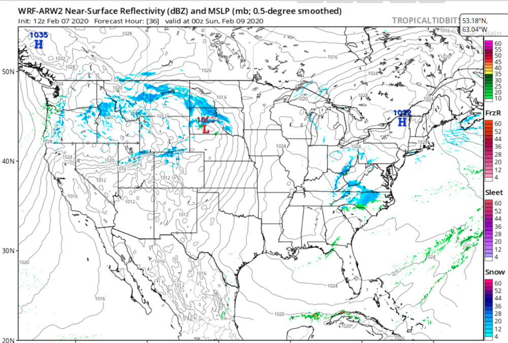
Some areas might go from having no advisory to warning level snows in the GSP forecast zone...
-
Per webcams, looks like roads are starting to cave
-
I swear, we do better in the south with these weak systems more consistently than big "blockbuster" storms. No mid-level warming and just enough moisture to make us happy, by our meager standards. The jealousy level to yall's north and east is unprecedented atm... Congrats!
-
2
-
-
Just now, sarcean said:
What’s the chance of Charlotte getting some decent flakes?
Increasing
-
2
-
-
Me thinks Greenville peeps will be happy by day's end...
-
 1
1
-
-
Just now, mackerel_sky said:
Nothing like putting an advisory out, after the ground is white, and everybody caught off guard!
They just like to keep everyone on their toes!
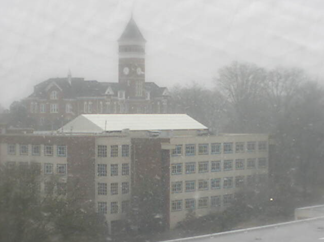
For real though, those Clemson live cams are impressive. It went 0-100 real quick and is RIPPING there!
-
2
-
-
It's looking like GSP got caught with their pants down... Especially for Oconee and Pickens counties
-
 2
2
-
-
If this holds together AT ALL, Greenville may have a shot at an inch.

-
1
-
-
3 minutes ago, mackerel_sky said:
Another bust for GSP! In honor of Brick, somebody post the “ it’s happening “ meme!

I caution you on your optimism, it's contagious
-
Snowing at Clemson University per webcams! Man I wish I was there
-
2
-
 1
1
-
-
Wow

-
1
-
-
I bet it's a good feeling in the areas where the snow is falling. No more model watching. No more 10+ day storms. No more snow depression. From the outside looking in- enjoy whatever falls it's a miracle you were able to score in this pattern! This storm had about a 12 hour window in this cold air after the big system yesterday and for once the pieces came together nicely for you guys!
-
1
-
-
ATL, N GA, and Parts of the upstate may hit climo with this storm. That wouldn't even be fair looking at the yearly stats years from now
Meanwhile I was happy to see graupel yesterday for 5 min. I wish I could find another cliff I've jumped off every one available so far.
-
1 minute ago, Lookout said:
lol it is above me...just virga right now. I'm guessing within 30 minutes it should be doing something.
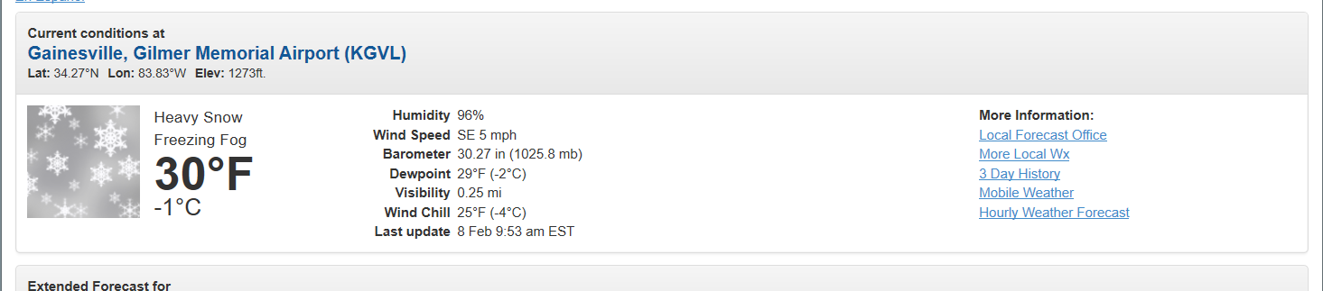
Snowing and 30 degrees now at gainesville..nice to see those subfreezing temps materialize as expected there.
given how cold 925 to 975mb temps have been forecasted and the radar looks excellent, it's a bit surprising gsp hasn't been more bullish for the upstate. . 950mb temps as cold as -2c at gsp and freezing levels just off the surface. That should be more than cold enough to allow for some accumulation.
I agree. I know the models predicted a quick warmup but with those cold 925's, earlier arrival of precip, and colder than forecast lows this morning, I would be shocked if the Clemson-Greenville area didn't get some accumulation. This storm would have to completely dry out and it looks to be coming in with a good slug of moisture atm
-
1
-
-
Wow optimal radiational cooling last night! When I went to bed I didn't know if we'd hit freezing but checked my temp gauge this morning and we bottomed out at 25! Currently 36 and a WINTER-like feel outside, forgot what that was like... Heading to the farm today looks like a perfect day for it!
-
All Hail King NAM with this system! Like eyewall said, this storm isn't going to help us Raleigh peeps, but I am certainly living vicariously through you N Ga and upstate folks today. Traffic cams in NW Ga look like a solid snow event incoming. Man it's nice to see a mood change around this board, even if it doesn't help my neck of the woods
-
3
-
-
From ATL:
Area Forecast Discussion National Weather Service Peachtree City GA 305 PM EST Fri Feb 7 2020 .
SHORT TERM /Tonight through Saturday Night/... Mostly cloudy skies expected to break up this evening allowing temps to fall to the low- to mid-30s tonight and tomorrow morning. A h850 shortwave is expected to sweep through the southeast tonight and tomorrow morning, with relatively smaller PWAT values but enough to produce a tenth to a half an inch across the northern CWA. With temps just above the surface below freezing this means winter precip will be involved, and even though QPF is expected to be low, it will be enough with an approximate 7.5:1 snow-water ratio for minor snow accumulations to occur with a rain/snow mix across North Georgia. Only about a tenth to a half inch of snow accumulations outside the mountainous regions are expected but with rains and warm ground temps, if anything falls it probably won`t stick around long. In mountainous regions up north this could be a different story. Embedded in colder temps, areas of NW Georgia could see 1-2 inches, with higher elevations along the spine and mountaintops of the GA Blue Ridge mountains could see up to 4 inches in some isolated locations. This has prompted a Winter Weather Advisory for the majority of Northern GA. Temps may climb into the upper 30s before the transition from snow to rain occurs with some slick spots possible where any accumulations occur. Temps tomorrow night will also drop back into the low-30s for N GA, which may continue to cause some slick spots Sunday morning.
-
1
-
-
Wow! A winter weather thread! I forgot what this looked like here!!!

-
1 minute ago, NEGa said:
Well my phone just off for a weather advisory. Hoping the trends continue on this one - even an inch at this point would be a win lol. It’s 36 and cloudy right now
I think you're in as good a spot as any for this system. Good luck!
-
Graupel showers in Raleigh at my house in North Hills right now! First frozen precip I've seen AT THE HOUSE this year (saw some snowflakes on the beltline in November) lol
-
Also, I know nothing about this model and will probably get crucified for posting it, but this would be a great treat for much of central NC!

2/8/2020 Snow Event
in Southeastern States
Posted
Never criticize excitement for any snowstorm outside of the mountains in this sub forum. If everyone here had already had 10 events, this one would still get just as much attention on this site and that is one of the things that is great about this region. 1 inch storms are a big deal to a lot of posters bc the other 364 days in the year we don't get to see snow make every flake a blessing! Happy for the guys that scored, that was a big storm for some of the posters on here! A 6 inch storm anywhere on this board is a good one, especially when it over-performs and stays all snow throughout! Enjoyed living vicariously through yall for the day