

NorthHillsWx
-
Posts
5,512 -
Joined
-
Last visited
Content Type
Profiles
Blogs
Forums
American Weather
Media Demo
Store
Gallery
Posts posted by NorthHillsWx
-
-
Significant outbreak underway. Multiple PDS warnings and a tornado emergency already. Wow
-
NWS confirmed EF1 from yesterday’s storm in RTP.
-
 1
1
-
-
1.06” of rain to end the month with a monthly total of 7.37.” Happy for a wet month when we need it before the furnace
-
Just now, Brick Tamland said:
Where is it headed? My mom and kids are at the house in Wake Forest.
Brick id tell them to take cover soon. Looks like it lifted but it’s headed that direction
-
They got the warning up… after it touched down
-
Just now, Blue Ridge said:
It did the thing

Definitely otg now. Classic debris ball showing on CC
-
Shocked there’s no warning! Debris signature showing up now
-
Looks like a TOG NW of morrisville!!
-
25 minutes ago, Blue Ridge said:
If there’s a cell (or two) that will do the thing in the Triangle, it will likely be from this cluster west of Sanford.

Yep, severe T-storm just posted for these. One thing I do know is that’s quite the slug of moisture incoming for the triangle. Commute is going to be a mess, at a minimum
-
12 minutes ago, Brick Tamland said:
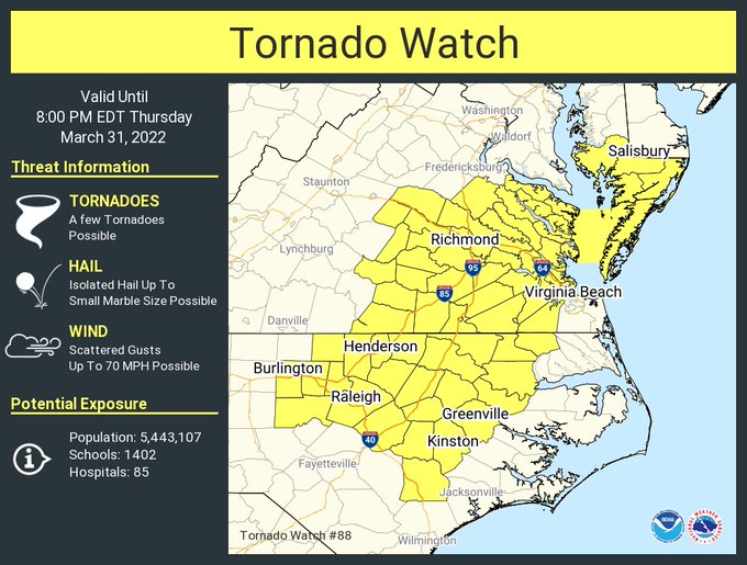
A new tornado watch has been issued.
Active day with warnings so far but I have not seen anything indicating a touchdown yet
-
19 minutes ago, Brick Tamland said:
Radar showing rotation west of Richmond. Haven't heard any reports of a tornado on the ground.
Went directly over my cousins office in Lakeside! They took cover under desks and said there was a visible funnel/lowering after it passed!
-
3 minutes ago, yoda said:
Two TWs just issued by RAH
Tornado watch southern piedmont into SC. Going to be an interesting afternoon. Stay safe all
-
1
-
-
5 minutes ago, eyewall said:
If it wasn't raining ahead of it I would have the drone up.
It may miss me to the east but the southernmost cell has a nasty look to it
-
Severe thunderstorm warning now
-
14 minutes ago, nwohweather said:
Definitely is a MIdwest October type of threat today, however it does look like some moderate instability and ample moisture transport will be in place this afternoon for the Carolinas. I actually expect us to be under a Tornado Watch shortly
Storm west of Fort Bragg has actually developed some rotation. Seems like a day a spin up could happen quickly
-
20 minutes ago, eyewall said:
It looks pretty junky out there. This won't be one for chasing and decent shots it looks like.
Nope. Watch the activity developing around southern pines. That could become severe out ahead of the main rain. I think we have two shots of severe potential, those storms developing then whatever develops along the front later on. With this wind energy it really won’t take much to get 50+ mph gusts from any elevated storms
-
Today will be the highest severe potential thus far this season from the central Carolina’s eastward. Timing works out right and if we can get some breaks in cloud deck I think the severe coverage could be even greater. Definitely an afternoon to be prepared
-
Storm SE of Brent, AL has a NASTY debris ball at the moment
-
About a degree warmer than yesterday morning with a morning low of 30.9. Still cold!
-
1
-
-
29.8 this morning. Know our opportunities to get in the 20’s are becoming limited for the rest of spring, so it’s possible this was our last morning below 30 this season
-
34.2 this morning with very light frost on the roof. Freeze coming tonight
-
LOL at hour 246 on the 18z gfs
-
Finished with 0.67” at home and 2.31” at the farm in louisburg. We were definitely on the low end of the rainfall spectrum for this event but what a month it’s been, 6.31” in the bucket for March
-
My farm in Louisburg had a downpour this morning. 1.67” in about an hour
April 4-6 Severe Outbreak
in Southeastern States
Posted
The super cell that produced the above tornado is an absolute beast. Not everyday you see that structure in the low country. Terrifying