

NorthHillsWx
-
Posts
3,686 -
Joined
-
Last visited
Content Type
Profiles
Blogs
Forums
American Weather
Media Demo
Store
Gallery
Posts posted by NorthHillsWx
-
-
If I'm chasing snow 800 miles away it will be done on an airplane and I will be going to a ski resort
-
 2
2
-
-
2 days ago: "Temps are unequivocally not going to be an issue". I knew better:
On 2/17/2020 at 11:00 AM, BullCityWx said:As we've covered already today, the temps arent an issue where precip falls. The GFS doesnt have precip so evaporational cooling does not occur. This isnt a column where we're at 8c at the 925 level.
Agreed if you're only talking about seeing snow fall. For accumulations, temps are always an issue. Take the 2.8 system for example. Many areas outside of North Georgia and Oconee and Pickens counties saw snow fall with no mixing, but very minimal accumulations. Mid and upper levels were excellent so it stayed snow but temps at the ground never fully cooled below the 32-34 range and really cut into accumulations. With a system like this where precip looks to be meager at best, wasting any precip waiting for temps to drop that extra degree will significantly cut into snow accumulations. I agree the atmosphere is not an issue but the fact is the baseline temps are going to rely on evaporative cooling and rates to reach a point where accumulations are possible. It's not going to start snowing at 32 degrees and temps fall from there. I'm not going to be the "ground temp" and "sun angle" guy, but those in the upstate and charlotte areas might have something to say about that from the last system as the only efficient accumulations occurred at night or early morning (I know that's also when precip peaked with that system, but it does matter). That being said, the focus continues to be on pushing more moisture further north and letting the temp battle play out from there. That has been the limiting factor with this setup and continues to be so. The trends have been positive today from that angle. I know the take the cold first then worry about moisture approach, but to the previous post's point, cold is not an issue for it to snow with this system. It only will become an issue if we get to the stage of talking accumulations.
-
1
-
-
In his/her defense, if we had 2 snowless seasons in a row, some here would be contemplating a similar drive
-
 1
1
-
-
4 minutes ago, Snownado said:
There is a dude on another forum who is driving 800 miles from Tuscaloosa, AL to Elizabeth City, NC. Have people lost their minds ? Is a little snow worth driving 800 miles for ?
Weenie of the year (decade?) award goes to...
-
 1
1
-
-
Can't wait for the first cliff diver to step over the edge after that GFS run
-
16 minutes ago, griteater said:
HREF Precip Type
I'd take that!
-
1
-
-
45 minutes ago, yotaman said:
It is still at least 36 hours away so I don't expect watches or warnings to be issued until either tonight or by tomorrow morning.
Haha, issuing Winter Storm Warnings the day OF the event without a Watch lol. Sounds like GSP on 2.8... I'd bet watches will be put out with the afternoon updates. They are probably waiting to decipher the 12Z data. I think that's the right call. I do think we will see watches and the NWS will become a little more aggressive with the new-found consistency pointing towards at least a moderate event...
-
I have become too emotionally involved in tomorrow's storm for my own good. Please bring me back down to Earth, people of the sanitarium!
-
Just now, PackGrad05 said:
The 12Z HRRR shows all rain for NC outside of the mountains.
The HRRR is a known torch. 2.8 is a perfect example.
-
4
-
1
-
-
Just now, PackGrad05 said:
Folks were discounting the NAM yesterday but now taking it into consideration when modeling the warm nose. I know it is typically pretty good with warm nose but this is also due to the fact it is really amping up the storm. The warm nose is directly related to how strong it amps up that low. If the NAM is overdone, then so is the warm nose.
Plus, the warm nose will go away with this storm as it progresses. It will not persist the entire time.Spot on. It is the absolute best model for depicting a warm nose. That used to be the model's only use for me... One good thing about the system is it is heading more east. Large Miller A storms with a prevalent warm nose riding up the coastline do not drag down colder ML's until the precip has ended. The trajectory of this system being more east move whatever warm nose out and sets up a decent period of snow for all areas Triangle-East. At least that's how I see it as compared to normal situations where the warm nose seems to linger until only flurries are left...
-
Just now, wncsnow said:
Hi Res Nam
.thumb.png.66780f52b6908464201b512b337fb615.png)
Anyone else impressed with the consistency of the NAM over the last 2 days and with the 2.8 event? Rock solid. Some noise but overall it has been the most steadfast model again. It used to be a model from which I expected the consistency of Clemson basketball run to run...
-
1
-
 1
1
-
-
6 minutes ago, eyewall said:
I never said it was a final call but yeah the sleet concern is always a real one in central NC.
It matches well with my thinking at present. Being close to the rain or sleet or whatever form of non-accumulating wintry precip we want to call it will be nerve wracking but it is ALWAYS where the highest accumulations set up. When in doubt, go with Climo for where the mix sets up (Somewhere in Wake county) except in this case eastern sections will benefit from the LP once it gets cranking and I think it will benefit us in the Triangle as well as it pulls away. We just may waste a little extra precip.
-
2
-
-
Just now, FLweather said:
High sleet totals look possible for Northern SC and Southern NC.
With surface layer above freezing high sleet totals will not verify or help with accumulation, if sleet is the precip type. Takes a lot of sleet to accumulate and usually has to be below freezing for anything other than mulch accumulations. This will skew clown maps, however, in the weenie direction. My worry level about the ML's is increasing for the Triangle area and points SE but not folding due to one run of the NAM. Sticking with my calls for now!
-
1
-
-
Taken Verbatim, Raleigh and points south and east should not like this run of the NAM, no matter what clown maps may show. I don't think this is a big sleet storm. I think "pink" will be more of a rain and wintry mix. No accumulations in that time period. Good news is, it's the NAM! Probably still a little too amped. Discredit at your own peril though this close to go-time. Still a decent storm regardless. NE parts of the state look to jackpot the more model runs I see.
-
1
-
 3
3
-
-
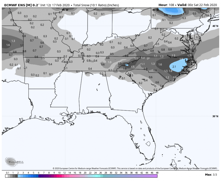
Trends for the storm:
Favorable
1) Models coming together favoring the higher moisture outputs from the NAM. A mix of the NAM, GFS, and EURO yields what I'd expect and I'd think the NAM would continue to scale back somewhat while other models meet it in the middle
2) NW trend has stopped. We have the moisture. More NW movement introduces more people in the current "snow zone" to the infamous warm nose. NAM is what I would rely on heavily for where that sets up.
3) EURO came onboard
Unfavorable
1) Earlier start time. Looking like for the RDU area and points west and south, start times have inched up to noon. This means less time for cold dry air to filter in before precip starts. Looking more and more like rain to start now and maybe a couple hours of it.
2) Middle of the day in late February transitions after rain do not point to efficient snow accumulations. With the chilly column (for much of central NC), I do not believe it will be particularly difficult to change to snow, like so many events are here, but this is strictly focusing on accumulations. This is all especially with wet ground and above freezing temps
3) While I believe there is enough lift to generate several heavy bands of snow, areas between these bands are going to struggle to accumulate until later in the even when temps dip below freezing. How much moisture remains at that point will be crucial for final accumulations. I'm agreeing with NWS here and think the term "white rain" will be used frequently during daylight hours tomorrow outside of the heaviest bands
All this aside, this looks like a decent hit to me for Central/Eastern NC. I do not think the CLT people will be as lucky.
My Updated Call:
CLT- Some snow but minimal to no accumulation
Triad-Roxboro- Increased what I originally thought due to more moisture and the coolest profiles. 1-2 in
Triangle- Increased due to more moisture. BL Temps have become an issue due to what I stated above. I'm going with 2-3 in but this could have been a 4-6 in type storm with more cold and less rain before the snow begins. Enough flakes will seemingly fall for that.
Sandhills- Temps the main issue. I'm going 1-3 in (similar to Triangle) with highest amounts N
Henderson-Roanoke Rapids- Increased here to me due to more moisture and better profiles. Going with 2-4 in, increasing to the east
Greenville-Rocky Mount-Williamston-Elizabeth City- Temps maybe slightly more of an issue to begin but storm gets cranking. I think this is where the band of heaviest snow sets up. I'm going with a pretty uniform 3-5 in storm with a couple of 7-8 in lollipops in there. Where the moisture meets the highest lift and the best timing for cold air and nighttime snow. I'd be surprised if a WSW isn't issued here
New Bern- still thinking 1-3 in. BL issues going to be main inhibitor, as will hours of rain before the switch. I think almost all of SE NC sees flakes but amounts will taper quickly SE of Newbern. A general Tr-1 in is a good forecast for these areas.
-
1
-
-
4 minutes ago, TARHEELPROGRAMMER88 said:
So, it is not warmer than the last run?
I'm not going to bicker on the storm thread but... You said "trending towards all rain" as the first frame of precip arrived. Of course, the run turned out to be an absolute hammer for much of the state. I'm not saying not to post what you see but at least wait to speak or back it up with something of substance, not just blanket statements. You're not the only one. Sorry if I come off wrong, there's just a lot of activity on here and clutter really dampens the great meteorological chat we come here for, especially as we work towards storm mode

-
2
-
5
-
-
Blending the NAM, GFS, and EURO, central NC looks like a good place to be. I'm hesitant to jump on the NAM being so far north with precip but it cannot be denied that pretty much every model is caving that way. That's not a mby forecast, just an ob based on the 18z runs I've seen
-
1
-
-
2 minutes ago, TARHEELPROGRAMMER88 said:
Warmer run from the NAM is incoming. It has slowly been trending warmer each run. Maybe trending toward all rain?
Real in-depth analysis... Wait till the actual precip moves in. Goodness gracious people
-
4
-
1
-
2
-
-
47 minutes ago, SnowDawg said:
Guys the NWS will stay conservative as long as they possibly can, sometimes to their own peril. I had a forecast of 0 inches and R/S mix 12 hours before getting almost 6 inches a little over a week ago.
Yes, for good reason. This is not a weekend snow that affects relatively low population areas. This is coming in on a weekday and has much more implications if snow does materialize. On the flip side, if snow doesn't materialize and the NWS hyped it up, it would get picked up by the media and turned into a forecast bust. I think they are doing the responsible thing here given the extreme model disparity atm. I think they did a good job explaining why they weren't favoring the snowier solutions at this time, instead of just throwing them out and running with the Euro/UK. From a keyboard meteorologist perspective, as 99% of this board (myself included) is, it is frustrating and it does sting and lead to anxiety (as reading the AFD last few days has for me) but we also do not have any liability in this forecast.
That being said, the negativity here is surprising. I know the Euro trends aren't great, but I'm not putting every egg in one basket. There has never been a storm that was ironed out 2+ days before go time. I think we are in the same place as we were yesterday. Obviously the CMC and GFS flipped but the GFS + Nam combo is certainly not to be brushed aside, especially at this range. Euro has flipped on this storm a couple times, as have the ensembles. I think we are slowly settling into a situation where the models will move into a compromise. For South Carolina people, this was never going to be your storm. There may have been a couple runs that threw you a bone, but this has consistently been N Ga mtns and a NC storm. It would not surprise me if the upstate saw flakes and some minor accumulations but temps most certainly will be an issue. The juiciest runs have tended to bring precip in faster which works against SC people as the cold doesn't have sufficient time to filter in. Also, the amped solutions do include the dreaded energy transfer, so foothills locations would not benefit with that either.
With all that said, if you were in charge of a public forecast 48hrs out with this storm, what would yours look like with everything you've seen so far? That is what these Mets have to do and that is a lot tougher than bickering over negative model runs or clinging to ones you like. I took a stab at it for NC. Here it is:
Charlotte - Moisture is biggest issue, temps may not promote accumulation before moisture moves out. 1 in high end. Likely- No accumulation
Triad - Moisture is biggest issue. 1-2 in high end. Likely- Dusting
Triangle - How much Moisture? 5 in high end. Likely- Dusting to 1/2 in
Sandhills- I think moisture will be fine here. I am not convinced temps will promote all snow throughout. 3 in high end. Likely- Around 1 in
Greenville- Best spot, imo. 8 in high end. Likely- 1-3 in
New Bern - Temps will be an issue on the BL but I like the consistency in crashing them with plentiful moisture. 5 in high end. Likely- 1 in
NE NC - Moisture is a big question here and the variability in accumulations obviously will depend on that. I think 4-5 in is the high end. Likely- 1-2 in
-
5
-
-
Well, the EPS certainly is trending better today. That's best news with this system yet.
-
2
-
-
Not too shabby
-
2
-
-
For the first time since this "threat" showed up on models, I have allowed myself to dream of glory (measurable snow lol) imby. Now I have officially opened myself up for disappointment. It's a vicious cycle in the South...
-
8 minutes ago, griteater said:
Buyer beware of the Pivot precip type map on the Euro. The map says rain for Raleigh, but the sounding says snow (very, very shallow above freezing layer at the surface which is likely too warm)...and the sounding output at the bottom right says snow...granted, precip is light


That is a snow sounding all day. Hi-res models will sniff that out when they get in range. Key is seeing a N/W expansion of precip trending over time.
-
3
-
-
Bottom line after today's runs is that a coastal low appears to be our best chance now and coastal lows do have a tendency to trend NW. Modeling will bounce around for the next few days but the players have entered the field from all camps and we are finally able to track something inside 4 days. Not every run is going to be better than the last one but I'd say overall the trends today have been encouraging. Obviously the CMC, which had a beautiful run last night, wasn't as good but it still had the same idea. Starting to see agreement 4 days out which to me is as good as we could ask for in this timeframe.
-
2
-
.png.709afed533eca78d6e4e73fbdc347082.png)

One More Shot: Feb 20-21 Event
in Southeastern States
Posted
What are we thinking temps will realistically be at go-time with this one across the board? Do we think BL temps warming into the 40's are going to be an issue? Models all over the place. Living here most of my life has taught me to usually go on the high end of guidance for an event starting in the afternoon, and low-end of guidance with the event starting in the morning (assuming radiational cooling took place without full cloud cover). I know we will wet bulb but, just from my experience, it usually takes much longer than we expect or models show.