

NorthHillsWx
-
Posts
3,964 -
Joined
-
Last visited
Content Type
Profiles
Blogs
Forums
American Weather
Media Demo
Store
Gallery
Everything posted by NorthHillsWx
-
WPAC or Caribbean on 11/2???
-
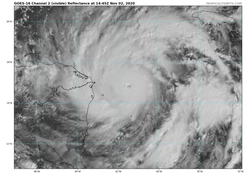
Ladies and gentlemen, we have a pinhole
-
I bet this thing is already 100-110 kts
-
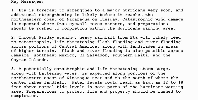
Pretty scary wording from NHC. Catastrophic wind, rain, and surge. Glad this is coming in a sparsely populated area and the core is extremely small
-
I think this thing may make it to cat 4. Very charley-like on sat
-
Give this thing 24 more hours over water and we may very well have a cat 5. Most explosive strengthening of the year ongoing on November 2nd. Bet the next flight finds a major
-
Pretty impressive October snowfall going on in southern New England. From a hurricane to an east coast snowstorm. Hopefully that’s a sign we can get some coastal storms despite La Niña this year. One can only hope...
-
I think Zeta, Sally, and Paulette all stand a chance to be upgraded to majors. Zeta and Sally have the highest chance because the amount of wind damage to assess and sample size will be much greater. It’s semantics but looking at 6 majors instead of 4 would make quite a difference on the perception of an already epic season
-
Pretty awesome hurricane footage
-
430k outages in NC right now
-
428,000 outages in NC on the Duke system
-
Probably 40-45 mph wind gusts. What the advisory had called for. Calmed down now. Still wondering why the upgrade to the high wind warning
-
I know, the western part of the state was always supposed to get that. It’s kicked up last 30 min. Nothing bad but gusts 25-30 for sure. Leaves blowing around good
-
High Wind warning now up for the Triangle with gusts to 60 mph possible. What changed? More efficient mixing of winds to surface with daytime heating? Not seeing any wind reports near that downstream of us in Raleigh
-
Nowhere near the same. This is an average sized storm booking it with winds picking up at very end. Katrina was a mid gulf monster and had days to buildup that massive surge. Not fair to even include this in the discussion with the K word down there
-
Would be the shortest thread of a major US landfall in AmericanWx.com history
-
No chance at cat 3. I’m only saying I do not think this is going to weaken. It’s still (slowly) deepening and sat presentation has improved since this morning. It only has maybe 6 hours until the eyewall is onshore
-
The problem with this graphic is that the first forecast point, 12 hours, the storm is already inland
-
This is not the same look delta had coming in. This is a well formed strengthening storm. Conditions won’t permit it to go crazy but this is still strengthening and has just about run out of time for any weakening to take place
-
On another note, the eye is now becoming visible on the long range LIX radar.
-
I think it, presentation wise, looks the best as it has yet. The deep convection is more consistent, it had that popcorn look when the eye feature was more pronounced, and it is popping an eye on visible as we speak. Recent trends and forward motion, I don’t see this weakening. I think cat 2, 85 kt landfall
-
-
NHC now going with 100mph near landfall
-
Me thinks intensity guidance is gonna bust low low after what I’m looking at tonight on satellite
-
Agreed. If this convective flare up persists, it seems it will, those pressures will come down quick. That’s a large amount of heat being expelled into the atmosphere


