

NorthHillsWx
-
Posts
3,964 -
Joined
-
Last visited
Content Type
Profiles
Blogs
Forums
American Weather
Media Demo
Store
Gallery
Everything posted by NorthHillsWx
-
For the convo about best looking storms we forgot a relevant one in this region: Mitch at peak
-
Plane must be dealing with radar attenuation
-
I said best looking. That giant cleared out eye approaching land was insane. Rita, Irma, Wilma, even Isabel all come to mind. Lend it to being more recent than the others but that was a perfect looking storm. edit to add Gilbert as well. Beast
-
Dorian was the all time best looking Atlantic storm
-
This is one of the funniest evenings on the board in a while. Good stuff folks good stuff
-
I can’t believe 2020 pulled off a cat 5 in November
-
Yep, they don’t get much better than this one, 2020 catching up to 2005
-
908 165kts
-
130 mph would be very conservative...
-
Without recon I wonder what NHC will asses as the 1 pm advisory? My guess is slightly conservative 130mph cat 4
-
I know and truly agree with what @Moderately Unstable said earlier but this thing looks and quacks much more like a high end cat 4 at the moment than anything else I think we’re witnessing historic strengthening ongoing. With the small eye you’re right, it’s allowed this raps level of deepening but is also extremely unstable to hold onto intensity at these levels for long periods of time. NEED RECON NOW
-
Holy crap. That’s amazing presentation for AVN. I agree, and this thing may be going into historic territory. I don’t think there’s a doubt in my mind recon would find a cat 4 at this point
-
Anyone have a classic AVN shot?
-
Y’all watching Eta this morning? Good grief
-
This gives me chills. She’s a beaut

-
You know it’s a solid storm when the resident board haters aren’t bashing it not calling out names haha
-
Let’s start a gofundme for the hurricane hunters lol. This site alone could sponsor several extra flights a year! lmao
-
Is it too much to ask for recon in the best looking storm of the year?!?! Lol. I’m pretty confident the data would be shocking compared to this mornings flight
-
Haha hard not to get excited with this one #satelliteporn
-
Oh I agree but these tight-cored systems can do it and it has the look and T numbers of a cat 4. This looks 100x better than delta as a 4 in the same region for comparison. With a tight core wind speeds can catch up much quicker to pressure falls and I expect an insane pressure fall when next flight gets in there. If it’s not a 4 it’s for sure a high end 3 and still deepening. It already shot up from 65 to 95 kts from 4 to 10 am and I think that rate of deepening has only continued
-
Also- I’d be shocked if this isn’t already a 4. I can’t believe I’m saying this after what I saw when I went to bed last night but this storm may make a run at cat 5. It is maximizing everything and developed the type of tight inner core that can lead to it reaching full potential in a hurry
-
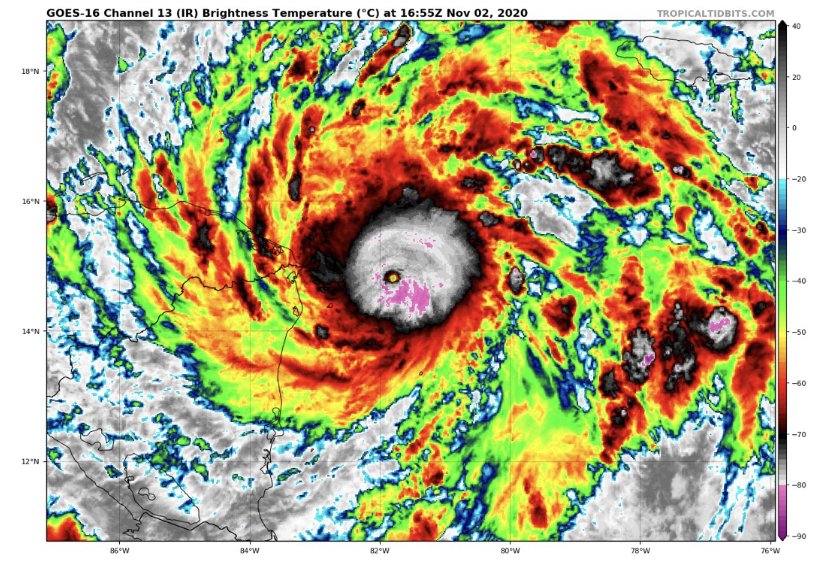
I think it is a cleared out warm eye. It’s just so tiny that it’s somewhat obscured by the high topped eyewall clouds around it and the satellite angle not being exactly above it. You can see it on IR and visible extremely vividly now
-
The fact we have this much tracking in November with non-junk systems is awesome for the weather nerd in me. This season continues to deliver the goods. I’ll take a back-loaded season any day. Eta likely to be this season’s strongest. I think we’re looking at a high end cat 4 based off this mornings trends, location, and tiny size of the system. Almost perfect sat appearance now. Eye rapidly warming and extremely cold tops surrounding a symmetrical core with well established outflow minus some very slight easterly shear. Nothings going to stop this from bombing until land or an unforeseen ERC which doesn’t seem likely due to the fact the core has just become established
-
Be some excellent data if one was in it right now...
-
Just silly deepening at the moment. These small core canes can really impress when everything aligns. May go from cat 1 to cat 4 between the 7 am and the 1 pm


