

NorthHillsWx
-
Posts
5,515 -
Joined
-
Last visited
Content Type
Profiles
Blogs
Forums
American Weather
Media Demo
Store
Gallery
Posts posted by NorthHillsWx
-
-
Did not quite get an inch yesterday but the 0.85” we did get from an unexpected very rainy day brought us to 4.65” over the last week and for the month. What a drought busting rainfall for many areas in central and eastern nc
-
 1
1
-
-
Working on our 3rd day in a row with over an inch of rain. Unbelievable
-
Pretty good rains this morning. Up over 4” for the last 5 days. Still raining lightly
-
2.07” on the day. 3.80” for the month
-
Pouring. This will make up ground for the summer
-
Finally got a rainfall over 1/2” maybe some more to come? Sitting at 0.57” so far, all of which fell in 20 min.
Ended with 1.21” which brings the MTD (and our 3 day total) to 1.73”
-
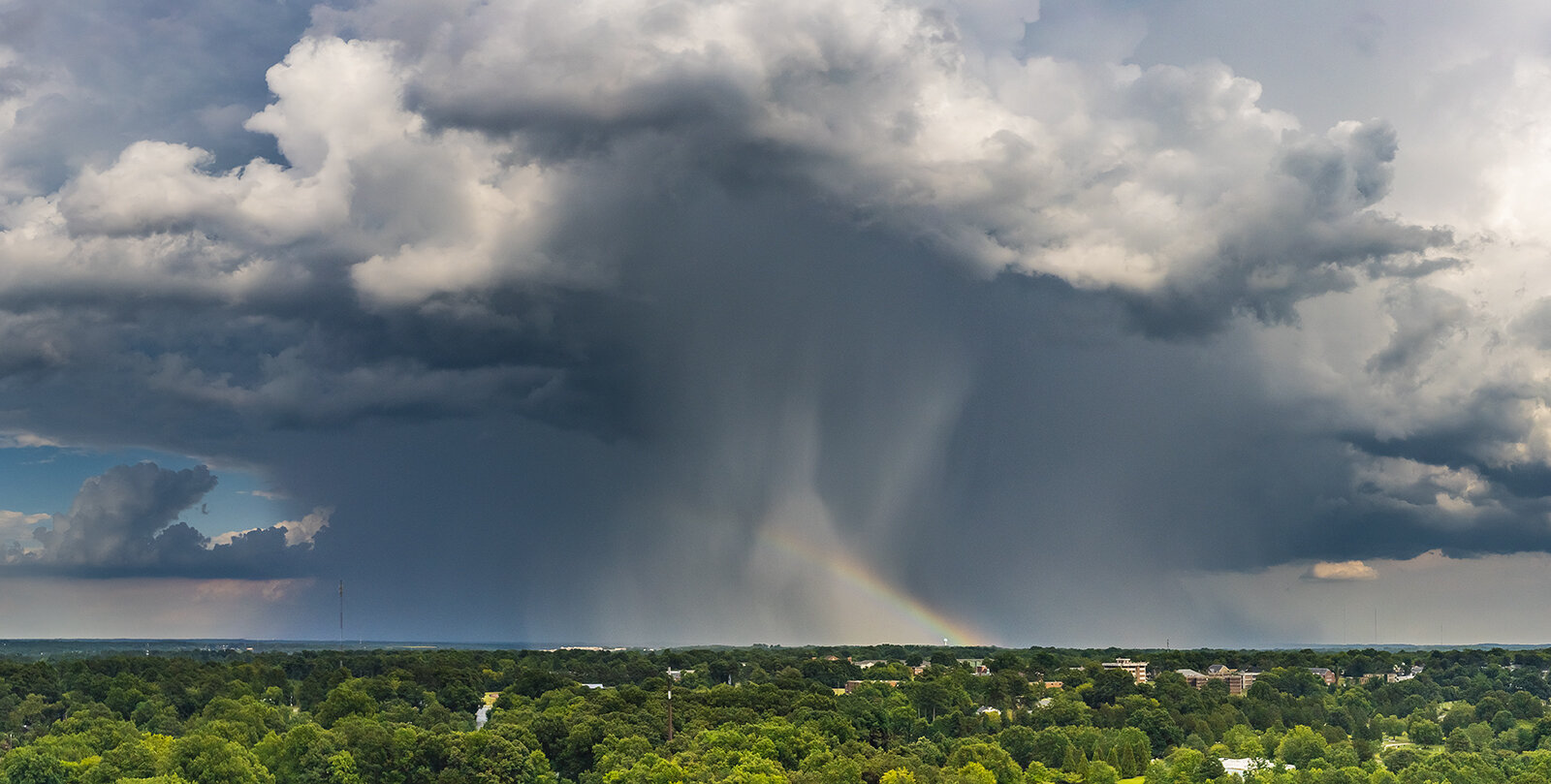
49 minutes ago, eyewall said:
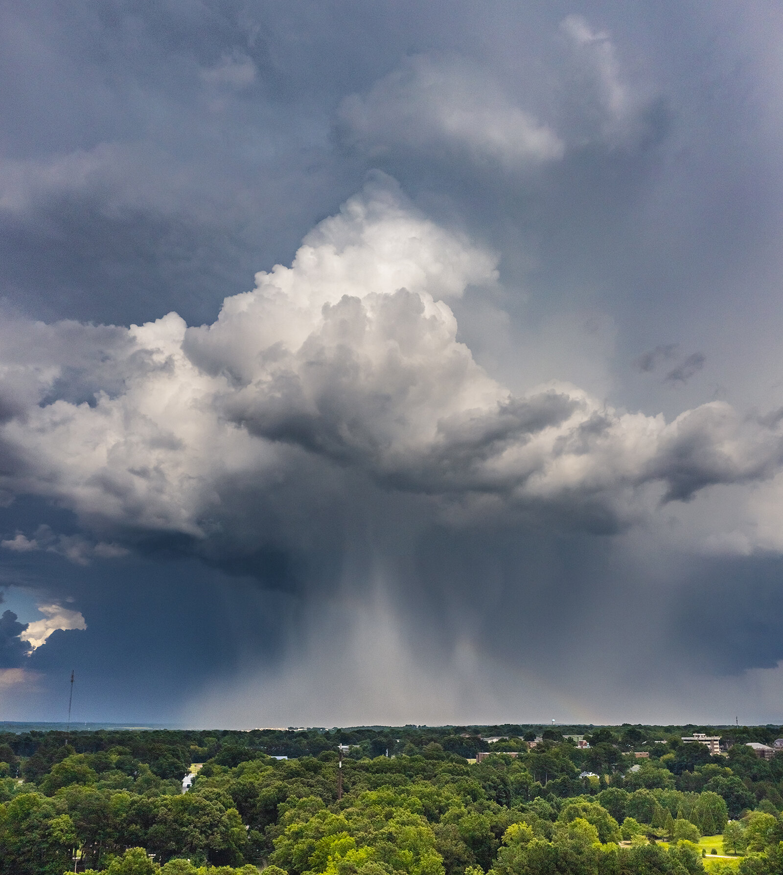
Pulse severe thunderstorm with downburst as it approached Knightdale looking from eastern Raleigh via drone (7/7/22):
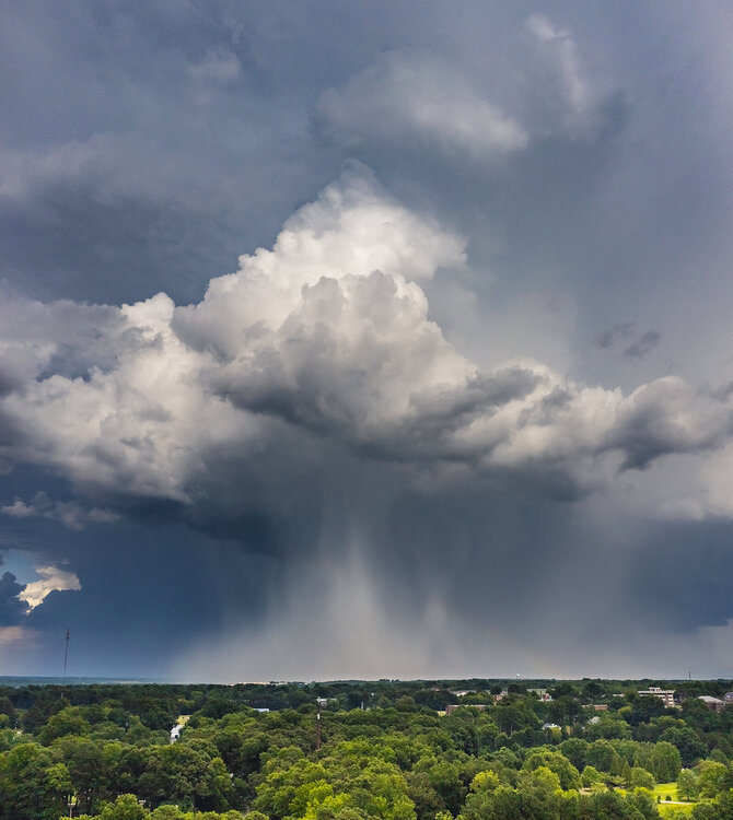

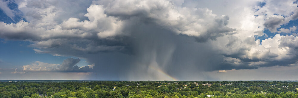
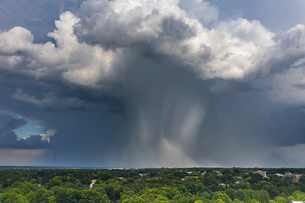
@eyewallyou always get amazing pics but these are some of my favorite!
-
1
-
-
5 minutes ago, WinstonSalemArlington said:
Doubts about accuracy aren’t confined to Triangle mets
RDU was 2 degrees warmer than my house yesterday and 4 degrees warmer today. That’s pretty significant variation for being so close. We did however receive close to a half inch of rain more than them last month and a half inch more than them so far this month
-
1
-
-
Topped out at 96.3 today. Highest HI was a scorching 107.2 which though way too hot did not verify our excessive heat warning.
For the second day in a row we got a thunderstorm which put and additional 0.16” in the rain bucket and cooled it off considerably into the upper 70’s. I’ll take these pleasant rain cooled evenings any day!
Looking at radar, it looks pretty meager out there for the 70% area wide rain chances advertised this morning. Feel fortunate to have gotten the storm we did
EDIT: Picked up an additional 0.07” for a daily total of 0.23”
-
Cloud cover *MAY* help us from a repeat of yesterday’s triple digit heat. We’ve *only* made it to 96 so far and it’s leveled off for the last hour or so. Still had a max heat index of a blistering 106 a short time ago
-
Upgraded to an excessive heat warning today. We verified one yesterday despite only having a heat advisory. Heat like this, even in the south, is quite rare. Usually our dew points mix out in the afternoon at peak heating but this is a pure soup airmass. Hope the advertised pattern changes noted above come to fruition. This has been a miserable summer
-
Missed out on the big totals just east of here but picked up 0.29” from a frisky storm that blew up overhead this afternoon. Broke 100 for the first time this year. 100.1 was our high. Storms were a fine consolation prize after the pain however
-
1 hour ago, WinstonSalemArlington said:
Suspicious???
Seems suspicious to me. We’re usually a few ticks warmer than RDU and it peaked here about an hour before that observation. We broke 100 for the first time this year and had our highest heat index since I’ve run my weather station so I think RDUs observation is off but it’s still our hottest day of the year by far
-
Hottest day of the year here. 100.1 with a max heat index of 111.7. RDU is reporting 102 with a heat index of 114. Much hotter than that well advertised heat wave that fizzled a couple weeks ago. This is brutal heat
-
18 hours ago, cbmclean said:
Right on cue the line collapsed in the east while remaining strong in the west. Just for fun after the main line faded a nice litle aftershock cell popped up immediately upstream then instanstly collapsed on my doorstrep.
I saw that, I was hoping you’d get that last gasp cell
-
3 hours ago, Windspeed said:
Now don't be argumentative. It was only the third costliest season on record..

While true, 75 or so billion came from a single storm. If Ida misses the US we’re all talking about 2021 being a lame season. Just some perspective on how a single storm can change a season. Nicholas was a damaging storm and ultimately a billion dollar disaster, but we won’t remember that name. The season featured only 7 hurricanes and 4 majors, both just slightly above the average. The season featured so many junk storms that only lived 1-2 days out in the open sea. I’m still pissed they named Odette and still don’t believe it was a tropical cyclone…. All that said, I know the poster above is known for spam posts, but 2021 really was unspectacular if you take away 1 storm. But that’s all it takes to make a season memorable
-
1
-
-
11 am confirms it, Bonnie is the first major of the year in either the Atlantic or East pacific basins
-
Bonnie looks like a major this morning
-
Bonnie has become a picturesque storm this evening. Very small eye and beautiful cloud pattern on visible.
-
1
-
-
4 hours ago, lee59 said:
Just checked coastal locations and buoys offshore and the highest I found was 23 knots. Has anyone found any buoy locations with 40mph sustained winds?
Frying pan tower is currently gusting to 44 kts, sustained at 30 kts
The location has been seeing sustained winds between 30-35 for about 3 hours and have a max gust of 46 kts
-
This looks like a TD/low end TS making landfall. I’ve seen much less classified
-
3
-
-
Highest temp: 99.7
Lowest temp: 54.2
Monthly Precip: 2.00”
The one positive I will say about a very hot and dry month overall is models and forecasts definitely overdid extended periods of heat for both of our heatwaves. 2 weeks ago we did near 100 but we got clouds and some storm complexes that offered much more relief than expected. We had an excessive heat warning issued and didn’t even verify heat advisory conditions. Last weeks heatwave was WAY overdone on models. We had two warm days then a pleasant week with several rain events. Otherwise, just hot and dry summer weather ruled the month
-
Much better rain coverage in the triangle this morning with a 20% chance of rain than a lot of days this month with 50-70% chances. 0.26” for the day, may get another shower or two. 1.96” for the month now
EDIT: picked up and additional 0.04” for a total of 0.30” for the day and an even 2.00” for the month! Did not think we’d hit 2” this month, but we clawed our way there somehow. Makes a very dry month slightly better
-
35 minutes ago, goldsborosnow said:
The .03" that fell in my backyard yard in Pikeville yesterday brings my monthly total to .35" for the month. Storms have missed my house by a matter of 1-2 miles in all directions over the last 4-6 weeks.
Ouch. That corridor along 95 has been exceptionally dry. We’ve caught the edge of a few decaying mcs systems but they did not make it much further east of here. I’m surprised the storms yesterday totally collapsed east of US 1. Models definitely were more bullish for the area than reality. I do wonder if the extremely dry ground and surface condo may actually work to thwart some rain opportunities and storm development


July 2022 Observations
in Southeastern States
Posted
Sitting at 80.6 with low humidity and partly cloudy skies. My oh my what a beautiful day.