NorthHillsWx
-
Posts
3,965 -
Joined
-
Last visited
Content Type
Profiles
Blogs
Forums
American Weather
Media Demo
Store
Gallery
Everything posted by NorthHillsWx
-
Looks rather juicy
-
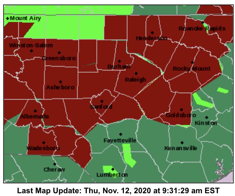
Current warnings
-
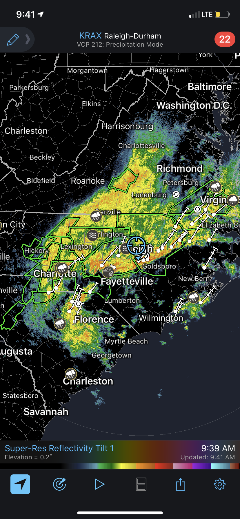
Starting a thread for observations from last night/today’s heavy rain event. Looks like widespread totals of 3-6 inches will verify and some heavier amounts likely. Here in Raleigh were quickly adding up the total. Up to 3.5” and lots to come. Widespread flash flood warnings now up
-
Bad reports of flooding in Iredell county
-
Strangely it’s been very dry here compared to the western half of the state. I think we’ve been in a two month deficit for the first time in what feels like forever. That will definitely help mitigate the flood potential here somewhat though with the current rates it may not matter much
-
Almost 3 inches in the rain bucket and the good stuff is just now getting to the triangle area. I think we’re going to land on the high end. I’d be shocked at less than 5 inches storm total looking at the radar here. Oh yea, 65 degrees and pouring atm
-
I’d rather be burning days in this pattern now than in December or January. I guess that’s my point. If it doesn’t change (last year) then we can sulk in March. Patterns that actually allow sustained cold are so fleeting in the south I feel the odds are greater we get it in the good months if we don’t waste it now. Absolutely no science or anecdotal evidence to that statement just a gut feeling I’ve had having lived my life in the south. If we were locked in an arctic pattern now we’d be enjoying our November morning freezes for a week then hoping for the pattern to “reload” until January
-
Already over an inch of rain here. Had some good thunder earlier. Rain bands look to be setting up nicely to our south. Feels like this has the markings of being an overachiever in the rainfall department
-
Eta is now the second highest ACE producing storm of the season. Pretty respectable for November 11
-
Convection has really collapsed on IR looks to be short lived at hurricane intensity
-
Any recon scheduled for Eta? Looks like the H word on sat even with the slight displacement of the center
-
There should be a pinned thread at the end of the year and awards given out for posts that aged the worst. Some of the ones from August complaining that the long range GFS not showing development meant 2020 was going to be a dud of a tropical season belong there as well
-
Some pretty decent footage from key largo last night. As I mentioned before this is evidence the system was very near a cat 1 when that core briefly wrapped up last night. Some of these winds certainly seem to be close hurricane strength. Doesn’t really matter but would’ve made for yet another hurricane landfall in the US during this crazy season. Certainly came close
-
Radar looks like the storm ramped up right at landfall and probably was near hurricane strength. Given the low topped storms, it’s unlikely sustained hurricane force winds occurred or mixed down effectively but it was probably close. Some gusts to near hurricane force were recorded. Key largo looks to have taken the brunt of that. Since then dry air choked off the core that had formed, a process we will likely see play out over and over again next couple days. Beyond that, guidance has definitely trended towards the storm missing the connection with the passing trough and in turn meandering and winding down harmlessly in the gulf as it feels the influence of dry continental air, shear, and decreasing SSTs. Still not certain but that’s been the trend overnight
-
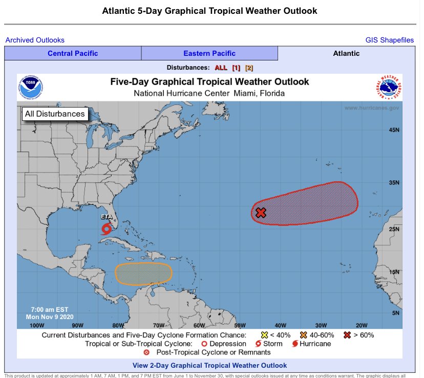
11/9 looking more like a mid-season tropical outlook
-
Had to turn AC back on yesterday. Inside temp had risen to 78. High of 79 low of 54. Torch continues
-
Resilient system aided by upper level divergence. Not bad for having dealt with 30kt of shear and having just crossed Cuba’s midsection. It seems reasonably vertically stacked. Might be extending our high number of US hurricane landfalls on the year
-
Now forecast to become a hurricane. Certainly seems reasonable. I am skeptical of the deepening shown on some of the models given the proximity to extremely high shear and dry air. It would really have to thread the needle
-
For real
-
Models are slowly coming into better agreement and this looks like it will be a fairly significant impacts for southern Florida. It will not be a high end event by any means but given the interaction with the closed low this should take on at least some subtropical characteristics which will lead to an enhanced wind field well away from the center and a long duration onshore flow for the east coast of Florida. Widespread power outages, especially given the antecedent rain and large wind field, are on the table too. This, meteorologically, is going to be an interesting one to watch as it may go from purely tropical to a hybrid on our doorstep and a strong hybrid at that. A minimal subtropical hurricane is certainly on the table with this evolution before dry air kills it in the eastern gulf. These subtropical attributes will allow it to pass over Cuba mostly unscathed and also develop through the keys despite land interaction. This is not going to be a high end wind event, I’m thinking it does make another run at minimal hurricane, but I do think it will bring widespread impacts to southern Florida and may be a decent storm for those there due to duration
-
Wow. Didn’t the worst of the eyewall pass to their south too? I know eta wasn’t at peak strength when it made landfall but it definitely had completed its ERC and had a rapidly improving sat presentation not to mention the time it spent raking the coast as it crawled onshore. 140 mph LF is nothing to shake your head at. If there had been more major population centers there this would’ve been disastrous
-
You can faintly see some westerly motion on the southern end of convection but, as expected, the system looks extremely strung out. With a consolidated area of convection ongoing though this isn’t in the worst shape considering the time it spent over land. Would not shock me to see it organize relatively quickly today. Shear for the moment isn’t terrible and it already has a weak circulation and is back over water
-
Though it’s tough to see a defined center at this point, Eta is generating a large blowup of convection this morning
-
I’ll take the torch in November and the first half of December if it means winter drops the arctic hammer on us afterwards!
-
I’m just going to say it... the board jinxed eta