NorthHillsWx
-
Posts
3,965 -
Joined
-
Last visited
Content Type
Profiles
Blogs
Forums
American Weather
Media Demo
Store
Gallery
Everything posted by NorthHillsWx
-
Bottomed our at 27 here last night. Frozen, crunchy ground. Winter like day today
-
It wouldn’t shock me to see some black ice issues tomorrow morning. Everything it’s still soaking wet and it’s supposed to get well into the 20’s
-
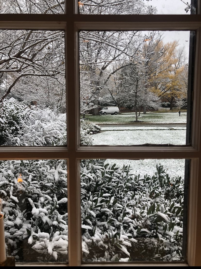
Had a nice burst of snow for about 10 min. Pretty with the Christmas lights on
-
Picked up night at 0.40” overnight and this morning. Don’t think any model had near that amount. Wish we had more phasing, slower system to work with the cold air moving in. Feel like I’ve said that 1,000,000 times being in central N.C. Maybe we squeeze out some novelty flakes this evening. Certainly feels like winter, temps dropped to 39
-
Pretty in Richmond

-
41 with moderate rain. Brother in Urbanna, Virginia is reporting moderate snow and grass covered and cousin in Richmond has a coating as well
-
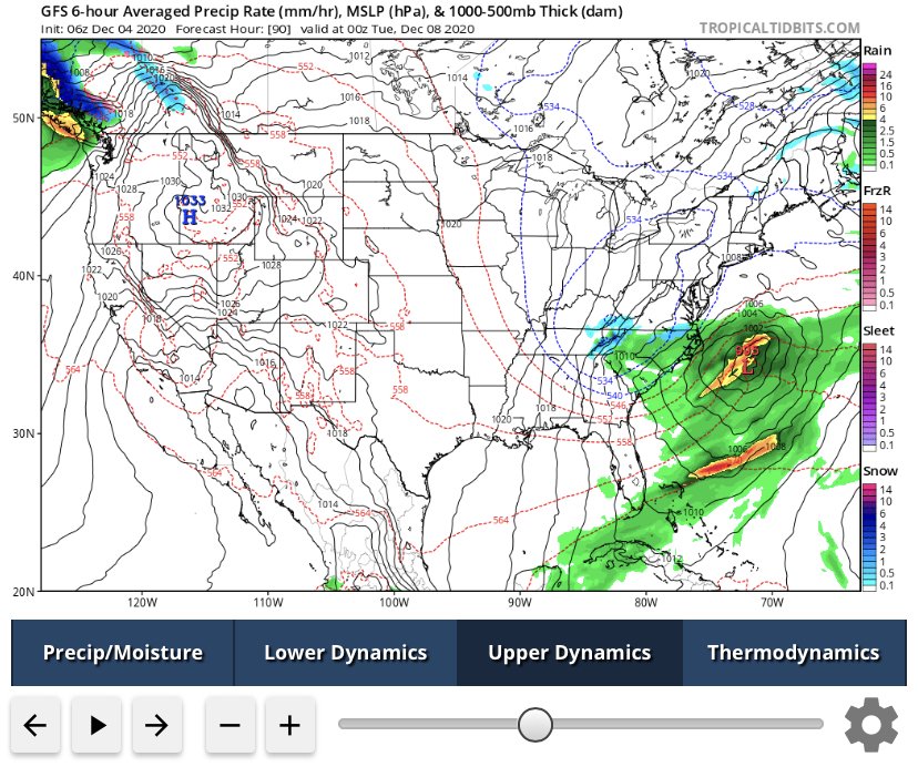
I mean boundary layer is pretty warm but this is an interesting look. System phases much sooner and further west. Not a bad look at all. Still missing the cold at the surface but one would think flakes would be flying for at least a period somewhere in the piedmont with this setup
-
This is actually very close and has continued to trend wetter/more phasing. It would not take much to make this setup work. It’s also interesting to note that this would be on the anniversary of the last major winter storm for most of the area
-
Coldest morning of the year imby. 25 with heavy frost. Good coffee drinking morning
-
The latter...
-
Just had a very heavy shower push through with 30-40 mph wind gusts. Looks like it was the last of the rain for us. 1.72” storm total. Temp 66 after the rain Shower, 71 with sun right before
-
1.64” in the rain bucket overnight
-
First below freezing morning imby. 31 and clear
-
Welp. Pattern looks craptastic for foreseeable future. At least we’ll dry out so we can enjoy our unseasonable warmth
-
I seem to remember 2018 spending 7 days in a row below freezing with multiple snows even down East... mostly i agree, but that was epic!
-
Widespread significant river flooding
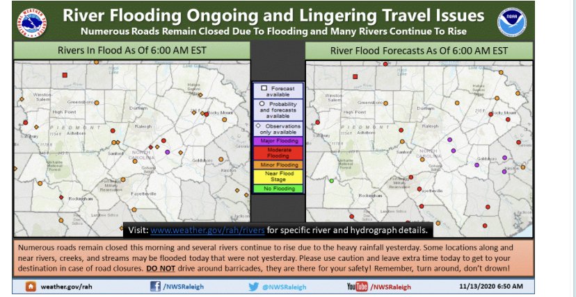
-
Neuse River at Clayton just below major flood stage
-
5.18” in the rain bucket. Looks to be finished up here. Pretty significant rain event lots of small scale flooding around the neighborhood including creeks and street flooding
-
This is going to be an impressive event given most of the state if not all will see at least 2-3 inches of rainfall with many areas in the 4-6”+ range. Definitely widespread and trended/verified on high end of every forecast. Widespread flood reports across the state with Charlotte and NW piedmont hit especially hard
-
Looks like western wake has seen a relative rainfall minimum. RDU is reposting only a hair above 2.5” for the event whereas areas east of there in the county are in the 4-7” range
-
Pushing towards the 5” mark. Thankfully the dry conditions we’ve had the last two months seems to be mitigating the flood risk. Still, plenty of small creek flooding in my neighborhood and standing water on roads. Mod-heavy rain continues
-
Rainfall rates have picked back up last 30 min after a relative lull. Ticking over the 4.5” mark at the house now
-
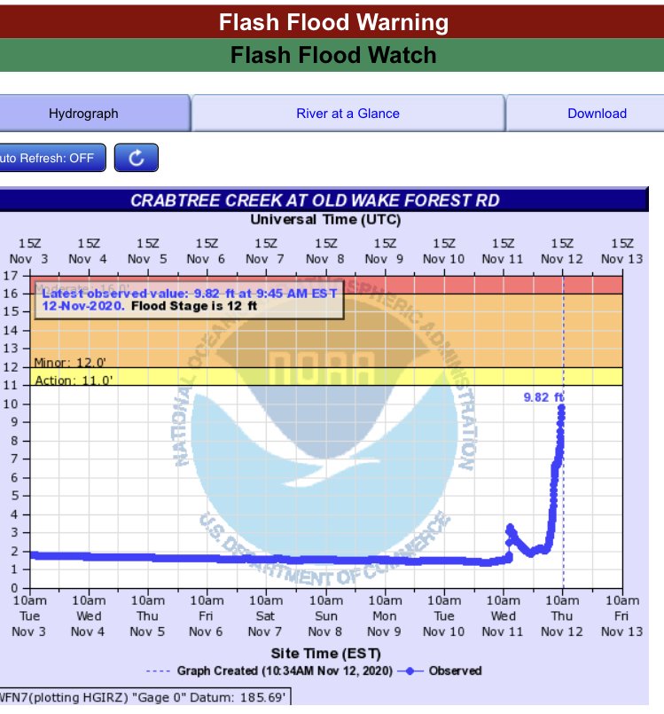
Crabtree Creek is approaching flood stage. The deluge has transitioned to a steady moderate-heavy rain. Looks to continue for better part of the day.

-
I think maybe the Danville Regional Airport reporting site would be a good nearby source. They’ve had over 5.25” so far
-
Had to recheck the rain gauge. Now over 4.00” giving me over 1” in last 50 minutes, downpour continues