

NorthHillsWx
-
Posts
3,965 -
Joined
-
Last visited
Content Type
Profiles
Blogs
Forums
American Weather
Media Demo
Store
Gallery
Everything posted by NorthHillsWx
-
NAM was... not good
-
It’ll be funny when we get a 60 page storm thread that devolves into observations including the terms “ripping” “fatties” then actually seeing pics of someone’s car topped and white trash cans and someone claiming they got an inch somewhere in the sub forum, ahh winter in the SE page
-
The splotchy appearance on the models indicates a truth with an ULL setup and limited cold air: accumulations are likely to be localized and not widespread. It may end up difficult to pin down where they will occur bc rates will need to overcome warm BL temps to get snow to the ground and even more so for accumulation to occur. I do not doubt someone sees some snow stick outside of the mountains but nothing in this setup screams a widespread storm and it may be county-wide or smaller meso scale banding features that setup that will be difficulty to pinpoint and offer very small windows for snow to fall and stick. Obviously the chance for these features to setup decreases with less dynamics and less moisture and lift as some overnight guidance has trended. Interesting system but I wouldn’t bet the house on seeing anything past token flakes outside of the mountains almost until we are now casting
-
I know posting long range snow maps is a lesson in futility but this highlights the upcoming potential to have multiple storms through the period. Looks to be an exciting couple of weeks ahead
-
Any model that nails the Raleigh snow hole so perfectly has to verify 100% of the time I’d think
-
Love when this board comes alive. I’m still skeptical about this coming fridays system given the lack of cold air around but looks like we may have several shots down the road. I’ll let the experts continue and I love the discussion. Thanks everyone!
-
Another over producer in the rainfall department. Just under an inch and a half, 1.44” in the bucket
-
No cold air source. No threat outside of mountains for significant accumulation imo. Verbatim models showing snow only in heaviest returns. Upper levels decent but rate driven snow this far out is just something to cut out the boredom
-
Pattern better hurry up
-
26 degrees this morning. Pretty sure we’ve seen more 20’s this year through December than all of last winter combined
-
Yep, I’m convinced Raleigh zeroes out on snow this year
-
12z GFS keeps a shred of hope alive for the 3-4th storm. Euro has it too. Poor HP placement means no arctic cold source but ULL overhead provides a cool pool with decent 850’s. Storm would have to generate its own cold air, in other words. We know how that usually ends up. But the track is favorable and the upper levels aren’t bad so there is a chance... this isn’t way out in fantasy land either. At least something to watch other than cutter city in the near future. Sucks to have a favorable LP track but no cold air but alas so is life in the south
-
This thread is better than this winter
-
Is it a good thing for snow in the South when the rain/snow line storm is halfway through Hudson Bay in mid-January?
-
Cold without snow is wasted cold
-
I’ve tried to stay optimistic but I am out of reasons to do so for the foreseeable future.
-
Last 2 winters probably had something to do with it...
-
Piece of southern stream energy looks interesting a few days after New Years. In this run the phase occurs about 12 hours too late for widespread snow in the south, but it’s very close
-
Currently 34 with snow flying on Christmas morning in Raleigh! Looks like snow showers will continue here for next couple hours albeit very light, still exciting!
-
I sure do love winter storms here and know the pain first hand of a near miss, but a very small terrible part of me does enjoy reading the MA forum when the inevitable inside the beltway screw job sets up for DCA... I can relate to those emotions too well
-
I’d take it at least feeling like winter and call it a win
-
35 with light rain. Few sleet pellets when it started about an hour ago
-
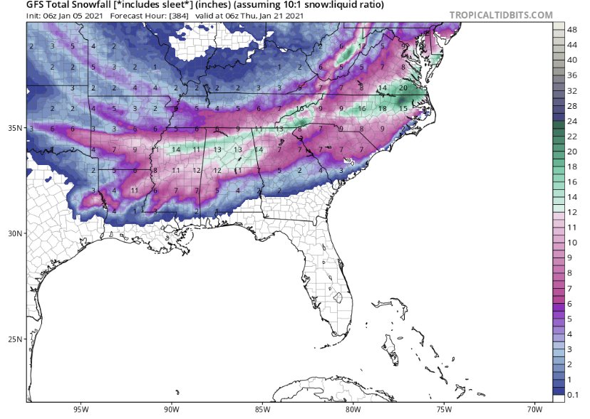
Heavy snowstorm (15-20 inches in rdu) temps in 20’s, freezing line at the coast, on Christmas??? Weenie run of the decade
-
Going to give today’s report based on yard mud conditions scale. 1 is dry as a rock in Saharan dessert 5 is wet enough for a bass pond. We’re sitting at a 4 right now, may call the hatchery this evening after this thunderstorm passes and see if they have any sales on some lunkers. Pretty sure the bushes next to my shed would make some good bass habitat.
-
In the Triangle, at least the Raleigh area, it has been some time since we had more than a nuisance ice event. Not that I’d want one, but we have not had a significant freezing rain storm in years


