

NorthHillsWx
-
Posts
3,726 -
Joined
-
Last visited
Content Type
Profiles
Blogs
Forums
American Weather
Media Demo
Store
Gallery
Posts posted by NorthHillsWx
-
-
Honestly we may need a thread for 90L. Looks robust this morning. Models have slowly been picking up on it, albeit weak, but as we just learned: never trust a gulf system. Another slow mover that may eventually work towards the Texas coast
-
21 minutes ago, JakkelWx said:
I still have my XBOX 360 from when i used to play video games a lot in the 2000s. Amazing how I'm almost 30 already.
Pretty sure that weather radio is older than you. It still works too, listened to it at the beach a few weeks ago
-
 1
1
-
 1
1
-
-
1 minute ago, Jackstraw said:
Maybe I'm just getting old, I mean I still have maps with thumb tack holes in them from the 80's. I tracked Hugo and Andrew on a thumbtack map, even took the map with me to Kendall trying to get my uncle to leave at the time. Yes, I thumb tacked map storms every day listening to the updates on the radio what y'all see on the NHC website today
I still have my NOAA weather radio with extendable antenna. One of my favorite parts of the summer was waiting for the new tropical updates, while going through the entire area forecasts and marine forecasts, to get coordinates to track storms. Didn’t have tacks but did have a dry erase map of the Atlantic basin and paper maps I drew on. Would love to find my maps from the 1996 season
-
1
-
 1
1
-
-
Just now, Akeem the African Dream said:
what another pos gulf coast landfall
Yes, Michael and Laura were total works of crap. I only respect dorians rolling straight into New Orleans with 35 foot surges and *recorded* gusts exceeding 200 mph with ground scarring as evidence and automobiles wrapped around trees with the tailgate touching the bumper, because anything less is more indicative of a cat 1
-
3
-
1
-
 2
2
-
-
This storm’s banter thread makes it a category or 3 higher in terms of human impact
-
3
-
3
-
2
-
-
Finished with 0.45” for the day
-
Had a shower about the width of my yard sitting over the house for last 20 minutes dumping rain. Not raining down the street but I bet we get a quarter of an inch

-
0.09” 24 hour total. Muggy as can be
-
2 hours ago, CheeselandSkies said:
How does the one in the Gulf not landfall??
Hits a brick wall
-
26 minutes ago, Prospero said:
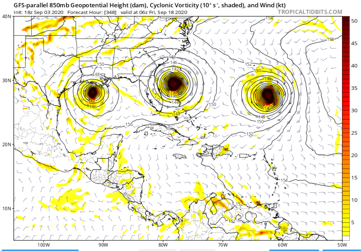
This would keep us all busy...

The crazy thing about that run, well besides 3 hurricanes lined up in a row, is it doesn’t landfall any of them haha
-
1
-
-
4 hours ago, hlcater said:
Yea 90% certain that Nana gets downgraded in post.
Idk it looked pretty robust coming ashore... Saw a 61 mph sustained wind report noted in the advisory. Being the system was tiny the chance of that being in the strongest winds seems very remote
-
3 minutes ago, WxWatcher007 said:
Once again, while the models did have a signal for development, virtually every global not named the Para GFS failed to develop a truly coherent tropical cyclone in the days leading up to development.
The models continue to struggle across the board with regard to TC genesis. Something to really pay attention to as we move into the next two weeks where there are a lot of impulses in the flow.
NHC earning their pay this season. Every one of their forecasts defied the models up until the very end for Nana. They’ve been incredible this season
-
4
-
-
Hurricane Nana
-
Yep, shear is going to win on this one. Levi’s discussion last night about the northerly shear imparted on the system by the ULL was spot on. Center has become exposed.
-
1 hour ago, cptcatz said:
11am update now has it maxing out at 70 mph.
In the discussion it says the system is expected to become a hurricane though the time interval this will happen is not shown
-
Picked up right at 4.00” yesterday. Though humid, was nice today with low stratus cloud cover hanging on past noon. Currently 81 with a pretty sunset on the way
-
1
-
-
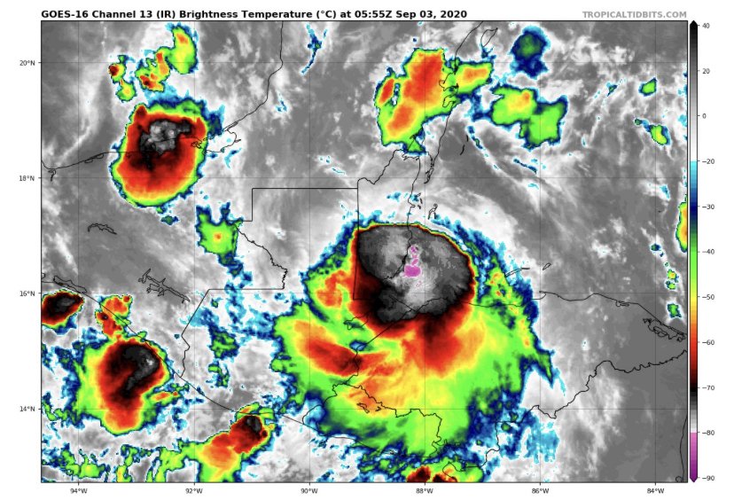
Nice blowup of convection over the COC. Let’s see what happens with it. Still some E, NE shear present. Rapid motion isn’t helping either but system still looks well positioned for strengthening
-
3 US hurricane landfalls (all strengthening on approach), one of the strongest storms to ever hit the US, and being on the “N” storm by September 1st sure doesn’t feel like a season bust!!!
-
1
-
-
The fact they found 60kt FL winds is amazing. Can’t think of a season where the global shave faired worse than this year
-
Small core of this system + improving shear conditions until landfall could lead to a quick intensification. These smaller systems can give us some surprises! I like that NHC went above the guidance with the intensity forecast. After seeing what recon found (tight core, high FL wind) this seems like one with the potential to ramp up quickly. I think we’ll be looking at a strong C1 by landfall
-
1
-
-
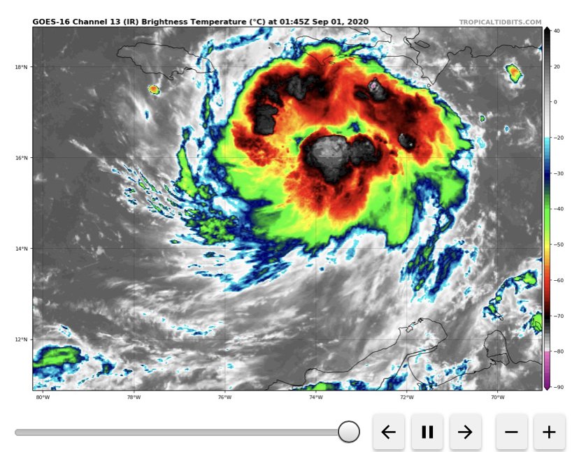
3 minutes ago, Windspeed said:
AF307 is almost in 99L. We'll know what we're dealing with soon enough. I still think winds on the north side will be strong enough to classify as a named storm if they find a closed vortex.
I’m anxiously watching to see what they find. This is a beautiful satellite appearance to not have a closed center. Has expanding outflow and persistent deep convection where you’d think the center should be
-
3.19” for the day and still coming down. Over 2.50” last 2 hours
-
99L looks healthy tonight.
-
Could see 2 more named storms in the next 12-24 hours. 99L has some potential to make a run at becoming a hurricane. 90 will be a wave producer on the east coast. Both look robust at the moment for invests. Hopefully 99L continues its rapid pace of movement to decrease strengthening and also flooding issues where it makes landfall in Central America
2020 Atlantic Hurricane Season
in Tropical Headquarters
Posted
Teddy should get us there alone