

NorthHillsWx
-
Posts
3,748 -
Joined
-
Last visited
Content Type
Profiles
Blogs
Forums
American Weather
Media Demo
Store
Gallery
Posts posted by NorthHillsWx
-
-
6 minutes ago, Prospero said:
Storm roulette!
"Spin the wheel, where she stops, nobody knows!"
For real
-
 1
1
-
-
1 hour ago, turtlehurricane said:
Models seem to be quite consistent over the last day about a Southeast Florida landfall of a strong tropical storm or even Cat 1 Hurricane. We will see, it's still up in the air and the track forecast is complex and uncertain, especially until we start getting real center fixes.
Models are slowly coming into better agreement and this looks like it will be a fairly significant impacts for southern Florida. It will not be a high end event by any means but given the interaction with the closed low this should take on at least some subtropical characteristics which will lead to an enhanced wind field well away from the center and a long duration onshore flow for the east coast of Florida. Widespread power outages, especially given the antecedent rain and large wind field, are on the table too. This, meteorologically, is going to be an interesting one to watch as it may go from purely tropical to a hybrid on our doorstep and a strong hybrid at that. A minimal subtropical hurricane is certainly on the table with this evolution before dry air kills it in the eastern gulf. These subtropical attributes will allow it to pass over Cuba mostly unscathed and also develop through the keys despite land interaction. This is not going to be a high end wind event, I’m thinking it does make another run at minimal hurricane, but I do think it will bring widespread impacts to southern Florida and may be a decent storm for those there due to duration
-
19 minutes ago, Windspeed said:
Wow. Didn’t the worst of the eyewall pass to their south too? I know eta wasn’t at peak strength when it made landfall but it definitely had completed its ERC and had a rapidly improving sat presentation not to mention the time it spent raking the coast as it crawled onshore. 140 mph LF is nothing to shake your head at. If there had been more major population centers there this would’ve been disastrous
-
 1
1
-
-
7 minutes ago, Windspeed said:
Visible since daybreak...

You can faintly see some westerly motion on the southern end of convection but, as expected, the system looks extremely strung out. With a consolidated area of convection ongoing though this isn’t in the worst shape considering the time it spent over land. Would not shock me to see it organize relatively quickly today. Shear for the moment isn’t terrible and it already has a weak circulation and is back over water
-
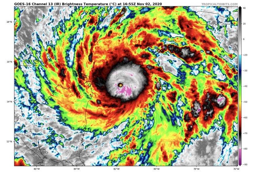
Though it’s tough to see a defined center at this point, Eta is generating a large blowup of convection this morning
-
4 hours ago, PackGrad05 said:
Raleigh is going to get really close to breaking the record for latest first freeze. December 3 is the record... Officially, RDU only got down to 33 earlier this week.
I don't see anything promising through at least November 20, unless that changes.I’ll take the torch in November and the first half of December if it means winter drops the arctic hammer on us afterwards!
-
I’m just going to say it... the board jinxed eta
-
 2
2
-
-
1 minute ago, JasonOH said:
This will have similar effects too: tons of rainfall causing catastrophic flooding.
Probably closest analog, just a little more north.
-
For the convo about best looking storms we forgot a relevant one in this region: Mitch at peak
-
Just now, justanotheruser said:
HOW DO YOU MISS
Plane must be dealing with radar attenuation
-
2
-
3
-
-
3 minutes ago, hawkeye_wx said:
Rita sub-900mb.
I said best looking. That giant cleared out eye approaching land was insane. Rita, Irma, Wilma, even Isabel all come to mind. Lend it to being more recent than the others but that was a perfect looking storm.
edit to add Gilbert as well. Beast
-
1 minute ago, nycwinter said:
dorian looked 10 times more intense on satellite..
Dorian was the all time best looking Atlantic storm
-
This is one of the funniest evenings on the board in a while. Good stuff folks good stuff
-
5
-
2
-
-
I can’t believe 2020 pulled off a cat 5 in November
-
3 minutes ago, Windspeed said:
Absurd...


Yep, they don’t get much better than this one, 2020 catching up to 2005
-
908 165kts
-
2 minutes ago, hlcater said:
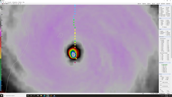
woooooooaaaaaaaaaahhhhhhh about as healthy as a pinhole can possibly be.

130 mph would be very conservative...
-
Without recon I wonder what NHC will asses as the 1 pm advisory? My guess is slightly conservative 130mph cat 4
-
1 minute ago, hlcater said:
Cat 4 is probably a good bet right now. Would like recon to get in there sooner rather than later, as eye is probably no wider than 6nm or so. An eye that small is not stable and I'm not confident that it maintains itself long enough should the 1730z recon plane end up getting canceled. Think it peaks sometime later today/this evening and kinda just holds steady into landfall. Whether or not this attains cat 5 to me is solely a function of how long can the pinhole remain stable?
I know and truly agree with what @Moderately Unstable said earlier but this thing looks and quacks much more like a high end cat 4 at the moment than anything else I think we’re witnessing historic strengthening ongoing. With the small eye you’re right, it’s allowed this raps level of deepening but is also extremely unstable to hold onto intensity at these levels for long periods of time. NEED RECON NOW
-
1 minute ago, Windspeed said:
Constant lightning going off in the eyewall. Recon may find a high end Category 4. Unless there is an ERC/structural change, Eta has our beat shot of attaining Category 5 this year in the basin now. Happens now or try again next year I reckon.

Holy crap. That’s amazing presentation for AVN. I agree, and this thing may be going into historic territory. I don’t think there’s a doubt in my mind recon would find a cat 4 at this point
-
Anyone have a classic AVN shot?
-
Y’all watching Eta this morning? Good grief
-
1
-
-
This gives me chills. She’s a beaut

-
7
-
-
You know it’s a solid storm when the resident board haters aren’t bashing it not calling out names haha
-
2
-
Tropical Storm Eta
in Tropical Headquarters
Posted
Now forecast to become a hurricane. Certainly seems reasonable. I am skeptical of the deepening shown on some of the models given the proximity to extremely high shear and dry air. It would really have to thread the needle