

NorthHillsWx
-
Posts
7,369 -
Joined
-
Last visited
Content Type
Profiles
Blogs
Forums
American Weather
Media Demo
Store
Gallery
Posts posted by NorthHillsWx
-
-
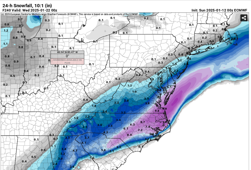
There are two opposite but very possible ways to lose and both are shown on models.
1) Suppression: our system is squashed by the extreme Arctic airmass and we miss out. I really don’t think this will happen. I think the cold airmass is likely over modeled and we will see some relaxing of the cold push as we get closer2) Cold hung up west of apps. I know this sounds funny given the Euro extreme cold but we’ve seen this tune before and Canadian demonstrates it perfectly. There are some hints of a SER forming this weekend and we should be well acquainted with those impacts and setting the frontal zone up over the Carolina’s versus over or off the coast. You end up with an overrunning event for the Tennessee valley. I am much more worried bout this than suppression with the ridge orientation out west and lack of blocking over the North Atlantic even after this weekends rain storm
There will be cold and moisture during the 19-26th period but there are clear cut ways to lose that are quite opposite of each other. Something in between is our path to victory.
-
 6
6
-
 1
1
-
-
EURO AI has a monster storm
-
2
-
-
12 minutes ago, Brick Tamland said:
NW trend baby!
Right where we want it
-
This place has changed since last year
-
3
-
 1
1
-
 2
2
-
-
2 minutes ago, Tony Sisk said:
….and then NAM will crush us with the truth.
There are few truths in life, but weenies weenying at D10 GFS runs and NAM crushing weenie snow hopes are two of them
-
1
-
4
-
-
1 minute ago, Brick Tamland said:
I have had one for almost 20 years. Why do you think I'm on here so much?
This made my evening. I might have an affair with the GFS if this teasing continues. So damn hot right now
-
1
-
 4
4
-
1
-
1
-
-
Beautiful storm on happy hour run. Parks the deformation band over the triangle for half a day think we’ll take that look lol
-
41 minutes ago, WinstonSalemArlington said:
I mean that screams SE winter storm threat. If you had to draw a snow distribution for a significant SE storm it would be that footprint
-
2
-
-
Given January thus far and what is modeled for the remainder of the month, most on this board look to not only finish the month BN, but WAY BN in the temp department
-
1
-
1
-
 1
1
-
-
2 minutes ago, StantonParkHoya said:
End of days for Raleigh. We’d never recover.
If anyone has school kids you could go ahead and kiss their summer break goodbye
-
2
-
2
-
-
1 minute ago, SnowGoose69 said:
All models show some type of wave trying to generate in the Western Gulf there, that is such a suppressive pattern I'd be surprised if anything showed up consistently before D4-5 because most ensemble members and Op runs will want to squash the wave
Exactly. It’s a very strong signal. Obviously we have no clue what the system will look like but I’m becoming confident pieces will be in play for a SE winter storm. This isn’t a model hiccup like we’re used to. Pretty much all suites are locked into that timeframe and we’re seeing winter storms pop on ops most runs. In other words, the pattern recognition is there
-
2
-
-
6 minutes ago, Cheeznado said:
No real ensemble support, this is as very likely much a fantasy as the 17" in Augusta that one long range model run had for this last storm.
No bombs like that but there are a lot of members showing a storm during the period. That’s ok with me.
-
1
-
-
1 minute ago, WXNewton said:
That's true, trying to not get excited when you see something like that is hard to do. However, the energy being modeled is only like 6-7 days out from working it's way towards us.
Yea. It’s nice to have had a storm and immediately have something to start to track without punting 2-3 weeks
-
Yep, a 1040 over SW PA is acceptable
-
1
-
-
Holy moly
-
1
-
-
Just now, lilj4425 said:
To what?
EURO
-
2
-
1
-
-
12z GFS drops a 1054 into the upper Midwest…
-
2
-
1
-
-
Hard to ask for much more than what models are dishing out in the 8-10 day range. I am confident we will be tracking through the period. What a change from last couple winters.
-
5
-
-
Low of 22 this morning
-
4 hours ago, VABILLUPS1 said:
GFS and Euro with extremely similar looks. EPS and GEFS showing support too. This timeframe seems like a credible threat at this juncture
-
3
-
-
23 minutes ago, BornAgain13 said:
18z GEFS for Day 12. This period is becoming more interesting.

That’s a fantastic look at this range
-
2
-
-
8 minutes ago, yotaman said:
James City, just southeast of New Bern.
Beautiful spot
-
1
-
-
2 hours ago, wncsnow said:
One thing is for sure, this winter isn't the complete fail that basically everyone was calling for. Last winter was supposed to be the best in years and was a total fail. This one was supposed to be a la Nina torch and it's been cold and a lot of us have seen snow.
The defeatist in me from living in the triangle disagrees as I watch the last of our 1/2” slop disappear from the shaded areas but you are right. This page has been “hot” pretty much since Christmas and we just had a forum wide storm and have had cold air pretty constant since new years
-
2
-
-
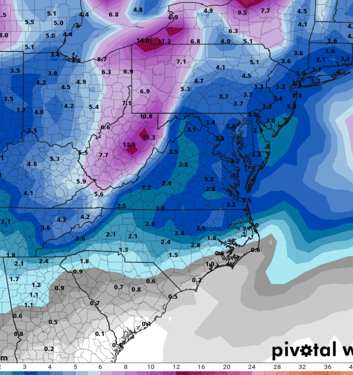
Biggest concern in this pattern would be cold stuck west of apps. Ridge orientation out west will be crucial to make sure cold is directed east and not just into Deep South. Does look like a wetter pattern. There will be chances. The 20th timeframe seems to be the next big threat. As models show, additional cold thereafter. Could be a fun end to Jan and, dare I say, start to fab Feb???
-
4
-

Mid to long range discussion- 2025
in Southeastern States
Posted
Correct. Should have elaborated