

NorthHillsWx
-
Posts
3,762 -
Joined
-
Last visited
Content Type
Profiles
Blogs
Forums
American Weather
Media Demo
Store
Gallery
Posts posted by NorthHillsWx
-
-
41 minutes ago, PantherJustin said:
Dude I get it, but why? Why throw that negativity out there right now. Just let them enjoy it. Maybe that’s why this board is cursed is bc all the negativity around here lol
Your positivity is appreciated but misplaced. No hope here, move along now
-
When ILM needs a cigarette, buckeye is speechless, and both grit and eyewall have something not depressing to say about this winter, something amazing has happened during happy hour. Only thing crazier would be Mack to jump back in this thread
-
 3
3
-
 4
4
-
-
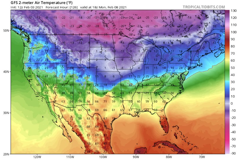
I guess the GFS decided to reward us for sacrificing the three systems before
-
2
-
 2
2
-
-
2 minutes ago, BullCityWx said:
I’ll gladly take a quarter of that run and call it a winter. That might be an all time run.
Need to save this run for the archives. Agreed, might be the best I’ve ever seen
-
1
-
2
-
-
9 minutes ago, ILMRoss said:
18z GFS is a banger for the entire board. Let's reel this in. I get it, yeah, 9-10 days out, but usually you can begin to hear the big dogs barking at this range.
And that is a big dog
-
5
-
-
4 minutes ago, CaryWx said:
Still hard to believe a 1050 will be out there. I tend to believe the artic surge is coming and with a stout HP...but a 1050?
Almost always HP seems to be over modeled at this range. Still, even if it lowers 10mb that’s still a stout high. I doubt 1050+ actually happens. I bet this trends north. I’ll take the cold look though. That’s pure arctic ice air floating around Canada and spilling into the lower 48, geeze
-
1
-
-
Life comes at you fast

-
1
-
-
59 minutes ago, BornAgain13 said:
The reason for the pessimism is because once we get another day or 2 from now , it will continue to be an "8-10" day threat... thats why folks are on the edge
Can’t go much longer with the 8-10 day range threats staying that far out. We’re literally running out of winter unless we want to add sun angle and poor climatology to the list of factors working against us. Has the now or never feel this time
-
1
-
-
1 minute ago, Wow said:
yup, i'll take it
Average HP...
-
1
-
-
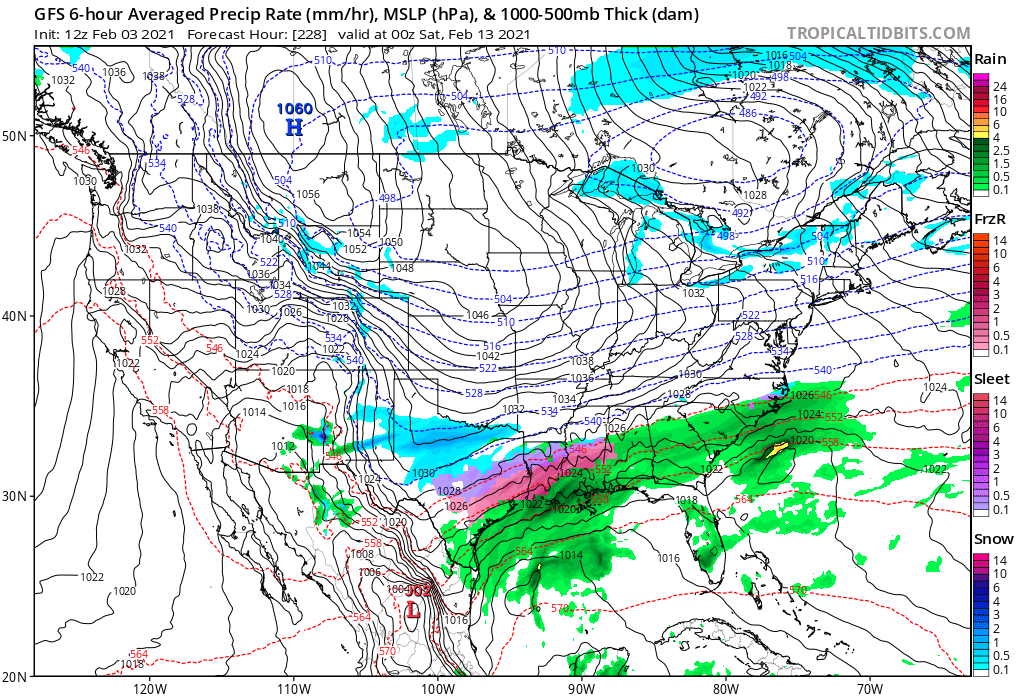
Feb 13-15 on the GFS looks like that one wild ensemble run from a couple days ago. Long duration overrunning event capped by the development of a NE GOM low and a 1055 banana high from the MW to the east coast. Sign me up!
Only problem is the storm is more than a week away (insert laughs)
-
2
-
1
-
-
3 minutes ago, magpiemaniac said:
The last few runs have trended somewhat favorably within that timeframe. Anything’s possible.
No cold air source for Sunday’s system. The issue exists in the mid and upper levels. That trough passing through the GL at that times keeps mid and upper level flow west to East, thus bottling up cold air from infiltrating. Storm track is good but it would need to slow down a lot for anything to happen frozen. Essentially, it would need to phase with that mid level energy or allow it to pass by for us to have any shot of cold air becoming involved. And that would need to be a situation of the storm producing its own cold air in the best case scenario. There is no high to force lower level cold into the area. I hate to say it but Sunday’s system is DOA even if it tracks perfect with the mid and upper levels so screwed up
-
27 for the low. Sitting at 30 with brilliant sunshine currently
-
12 minutes ago, BooneWX said:
The cold has been 7-9 days away every day since Thanksgiving. I said that Saturday but got blasted. Not trying to be pessimistic, I wish it would snow as much as the next person but I’ll believe the pattern when I see it.
Yep. Par for the course here. Pretty crazy to go from a high below freezing on Monday to a high in the 50’s. Hell the low on Monday may not even get below freezing. GFS is special
-
11 minutes ago, BullCityWx said:
There's snow in the carolinas on day 7.
Also has a snowstorm for savannah ga and an ice storm to the Gulf of Mexico at the end of its run so does say cold is coming, but once again, delayed
-
28 minutes ago, burrel2 said:
If we don’t score with the retrograding block and coldest air in the northern hemisphere trapped under it for a week or longer then I give up! You literally can not dream of a better situation than this.
Those on this board with expertise in pattern recognition have been honing in on this time period for weeks. To see it show up on modeling is pretty awesome. Hopefully we can score.
-
2
-
-
29 minutes ago, kvegas-wx said:
I may have to add this as a tagline quote to my profile. You could literally type this into any winter thread from Dec 1st to March 15th and be accurate.
This year we can't even be certain 24 hours out. And there are a few posters here that are so badly jinxed they couldn't get snow sitting under a polar vortex with snow guns pointed at their front yard. Somebody would still forget to turn on the water.

I'll retreat to the whining thread again.

At least give me credit for the quote!
-
1
-
-
Storm still tries to blank @Grayman cannot imagine the mental breakdown if that map was correct
-
1
-
-
1 minute ago, Cary_Snow95 said:
4-6 across the area. And temps afterwards are extremely cold for multiple days. Snow would be around a while. Perfect setup on the 12z
There is nothing to complain about with that system other than the fact it’s more than a week out
-
1
-
-
59 minutes ago, ILMRoss said:
Agreed haha ive seen so many “historic” cold blasts on 7+ day guidance get whittled down to less impressive cold over the years that it doesn’t even register with me anymore. It’s a complete blind spot. It’s almost always a a lock to not verify.In my humble opinion, this isn’t a bad thing if we want snow. I know these super cold blasts usually mean suppression city. It’s not like the cold disappears from the guidance either, it just doesn’t bleed into our region to the extent it did in some previous runs. It doesn’t need to be 20 degrees to snow. It still shows a prolonged period of below normal temps and an extremely active southern jet. I think we are in as good a spot as we can get starting early next week going out through the following week at least,
-
2
-
-
Flurries flying around now
-
RDU recorded a couple hours of snow flurries overnight
-
23 minutes ago, StantonParkHoya said:
Bet we see some MONSTER solutions in the coming days.
Agreed. Already some showing on the ensembles. One of these models going going to suck everyone back onto this pages in next few days. Been fun seeing the mid-long range thread “hot” most of the day. This winter is already 100% better than last winter
-
2
-
-
HRRR swings some snow through central NC late tonight. Something to watch, especially with cold temps. Could be a surprise dusting
-
12 minutes ago, CaryWx said:
The fact models seem to have this event next Wednesdayish and place it anywhere from below NC (miss) to up into Va (rain) is about the best we can hope for at this range given the model mayhem this season.
I’m just happy for the first time this year it looks like we will have a bonafide arctic airmass to work with. If last Thursday’s event had more cold air it could’ve been an area-wide warning level event. Was still a good storm. A few degrees makes all the difference as always
-
1
-
Mid to Long Term Discussion 2021
in Southeastern States
Posted
They lied