

MarkO
-
Posts
3,329 -
Joined
-
Last visited
Content Type
Profiles
Blogs
Forums
American Weather
Media Demo
Store
Gallery
Everything posted by MarkO
-
Just checked some of the elevations in the coastal Sarasota area. Much of it is below 10'. Considering the density of the population, this could be more costly than Ian. Hopefully it has time to weaken to a Cat 3.
-
Last few satellite frames are very impressive with the eye symmetry. Central pressure is probably back into the upper 800's.
-
New eye formed to the west of the former on radar. It'll be interesting to see what it does overnight.
-
Flightaware has it entering the eye now.
-
Those satellite images are impressive. Perfect circular eye. Likely still intensifying. This next update will be interesting. Could the central pressure be in the 800's?
-
Looking very impressive on latest satellite images. Likely a Cat 5 now.
-
Anyone know Cedar Key made out.?I believe the flooding there got to around 9'.
-
I'm guessing winds out of the east. They're probably peaking now.
-
Looks like landfall will officially happen in the next 10 minutes. Looks like those chasers are experiencing 100 mph winds now, going to be another 15 or so for Read.
-
Tallahassee will be ok, it'll wobble wobble but pass on the western side. It's moving quick north.
-
Storm surge hitting Cedar Key. 5' and rising
-
941.8 edit 940.2
-
Cedar Key area got to be experiencing some surge now. Wonder what it's going to look like in the morning. I hope everybody there evacuated.
-
Looking very impressive on satellite and symmetrical on radar. Eye seems to be clearing out.
-
on youtube search Hurricane Helene 2024 Live Stream
-
A little newer i the NOAA site: https://www.star.nesdis.noaa.gov/GOES/conus_band.php?sat=G16&band=GEOCOLOR&length=24&dim=1
-
Outflow more impressive on satellite. Unfortunately, the latest images I can find are about an hour old.
-
Looking at Google Earth, possibly 10-15 miles
-
Center looks to have an almost due north track over the past hour via radar.
-
The drier air (possibly influenced by the western side going over the Yucatan) has prettymuch been eliminated. Very favorable conditions for RI over the next 12-18 hrs. This is going to transform into a buzzsaw on satellite. Cat 5 possible/probable by landfall. Not sure how much fetch it can produce with that fast forward speed. But storm surge will be impressive let alone the winds. I hope people on the west coast of FLA up through the eastern pan handle take this one serious.
-

September vibes - Last 90s for some, 1st frost for others
MarkO replied to tamarack's topic in New England
I did, Congrat's Paul! -
September vibes - Last 90s for some, 1st frost for others
MarkO replied to tamarack's topic in New England
Quick passing shower yesterday (not enough to register), and 0.01" overnight. I've been watering the lawn to keep it alive (barely). -
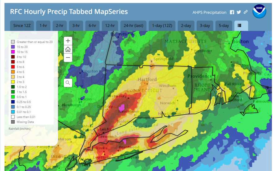
That's an incredible amount of rain for parts of CT and Long Island. Many of the cities and towns around me are having us design stormwater controls by the Cornell extreme precipitation charts, which are much higher than the ones we prreviously used. For example, my local 100 yr/24 hr storm used to be in the 6.4" range, and now it's in the 8.4" range: https://precip.eas.cornell.edu/#/
-
Did you shovel it into a pile? I know someone who would.
-
Got real dark in Lowell just before the cell. Probably one of the darkest mid-day thunderstorms I've seen. Lots of cloud-ground strikes in my area. Had a handfull within a mile.


