MarkO
-
Posts
3,401 -
Joined
-
Last visited
Content Type
Profiles
Blogs
Forums
American Weather
Media Demo
Store
Gallery
Everything posted by MarkO
-
Agreed on Cannon. It's really only that knuckle (for lack of better term) part of the mountain that is almost always icy. Got to do with exposure or something, but if you know where to go it can be a really fun mountain. I've also noticed all 4 destination mountains in that area (WV, Loon, and BW) have gotten much better over the years in terms of snow making although I think WV had technical issues this winter due to weather and some late upgrades to their upper mountain snow making system.
-

December 2021 Obs/Disco...Dreaming of a White-Weenie Xmas
MarkO replied to 40/70 Benchmark's topic in New England
Still snowing in Thornton, but I'm basing that on what I see on the webcam. Could be some freezing drizzle mixing in. 29.8/28. -
December 2021 Obs/Disco...Dreaming of a White-Weenie Xmas
MarkO replied to 40/70 Benchmark's topic in New England
So much variability this season, especially deterministic models. I'm not sure how you can be so dismissive, although I hear you in a sense that there hasn't been much at all to talk about in SNE. -
December 2021 Obs/Disco...Dreaming of a White-Weenie Xmas
MarkO replied to 40/70 Benchmark's topic in New England
Would be nice for some. Maybe warning criteria for parts of NH and most of Maine. -
7" in Thornton.
-
about 5", maybe squeak out another inch or two. Indy for the jack.
-
Off and on show showers all day, but temp has been just above freezing, so only a dusting this morning.
-
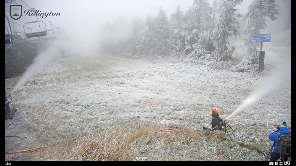
That's insane! They got to be producing at least an acre-foot of snow an hour. That main feed line has got to be at least 18" in diameter.
-
Last night's rain/snow line was in the 1500-2000' range. The bottom of Waterville was covered and it's at about 1850'
-
72 hours is what I was thinking they need. They can really pound Superstar with guns spaced at something like 50'.
-
It's white above about 2500'. I expected more, but it moved much quicker than I thought. Killington pounding upper mountain. I hope they can pull it off for the FIS.
-
I think it's going to play out similar to the October 17th storm of last year. Many hours of white rain for me, but piling up above 3k'. I think Phin and Alex will get some decent accumulations maybe in the 2-4" range, but summits will be at least 6, maybe up to 10+
-
Looks a little chaotic at Killington. I am a bit jealous.
-
Squall just dropped 3/4" in Thornton.
-
Yeah, been watching Killington make snow all day via webcam. They're blowing on North Ridge and top 1/4 of Superstar since at least early this morning. By the MWN temperature profile, looks like they could make snow down to about 3500'. It had been flurrying as well. I met my wife at a ski house at Sugarbush. We used to pack a dozen 20/30 somethings into. After we got married and settled down, we did a MLK weekend at Sunday River. It was a costly nightmare. I figured there had to be a better way. So when things slowed down for me with work, we took $120k in equity out of our house and it just gave me enough to build the cabin. Now that it's paid off, my only expenses on it are taxes, membership fees and utilities. It still ads up to over $10k/yr, but at less than $1k/month, we can pretty easily swing it both working in the Greater Lowell area. As for passes, I get my White Mountain Superpass. It ain't cheap, $1279. I wasn't sure I was going to do it this year, but I designed a replacement septic for a friend, so he paid for my pass in return. Friends helping friends out. I also used to get the free season pass to WV for my kids when they rented seasonal skis from Ken Jones ($150/yr each), but now that they've outgrown it, I think my kids will be spending most of the time at Campton Mountain, and I'll just get the day discount passes for WV our community gets. I think it'll be around $60-70/each. As J Spin mentioned, season passes (generally speaking) are far more affordable (aside from mine). Back in the late 90's a season pass to Sugarbush was $1500!
-
We do have a snow cat. Our groomer thinks he can do it. Granted we'd need cold temps as you mention. Thanks!
-
112.8 mph? Has this been confirmed? https://www.wunderground.com/dashboard/pws/KMATRURO16
-
Campton Mountain is right! Killington has the capacity to cover a trail in probably 24 hours, although that's really a guess based on what I've seen them do on a trail like Superstar.
-
Nice northern tick on NAM and high res. Winds starting to pick up from mid-day lull. Should be a fun night.
-
The fan gun has 200' of hose/electric. We can't blow it up top due to pressure/electric/water being at the bottom. It's about 200' vertical from where we can blow from to the top. Next winter we hope to install a snow makign system, but trying to find out if we can cover one trail in December. Taking into account how much time it takes to cover an acre, I think we have the time to produce the volume, should the temperatures cooperate.
-
Maybe PF can answer this question. We have one fan gun we cover a 1 acre practice slope with. Do you think if we move it a little farther up the mountain we can cover another 2+ acres pushing it up to 1000' to the top of the chair lift ramp?
-
Looks pretty cool on water vapor. Looks like it has subtropical characteristics. Currently moving into colder SST's, but it was over what I believe were warm enough. Edit, never mind, temps are colder than I thought.
-
HRRR looking a little south and weaker.
-
I think I beat Killington's announcement to the punch.
-
Looks like Killington began snowmaking this AM.