MarkO
-
Posts
3,401 -
Joined
-
Last visited
Content Type
Profiles
Blogs
Forums
American Weather
Media Demo
Store
Gallery
Everything posted by MarkO
-

-
Dang! Headed up to Thornton just for the night. Passing lane was closed at around exit 27, with tree in lane. Not sure if it was straight line or tornado, but missed it by about 15 minutes. No power.
-
R/S line appears to be around 2500' give or take.
-
Back door sea breeze just came through and dropped the temp from 85 to 75 in 30 minutes. It's actually refreshing.
-
It's actually closer to 0.75" here in Lowell, but there's probably 0.5" of sleet in there, so it's still going to have to get shovelled. I can't believe another crappy, cold, cloudy day. My forecast high is 32F.
-
Naah, it was mostly pingers. That's 90% crack.
-
Funny you post this. I'm lying in bed too lazy to get up. I looked at my webcam and guessed about an inch in Lowell. Checked the NWS map and the only post was Lowell reporting 1" (wasn't me), so I can stay in bed although I do have to pee. F'k it I'm up. Sucks getting old.
-
Cold is draining in from the NE. It's a mix of sleet and low level snow needles. Ground is covered for the most part (except part of the street). 32.0
-
flipped to sleet, 32.5.
-
Amherst NH? Plain rain here, stuck at 32.7
-
down another degree to 33.1/31.0. The soundings show a cold layer of about -5C at about 2500' and a narrow layer at 1C at about 6000', so whatever falls should be frozen which should be snow during the heaviest parts.
-
34.0/31.4 slowly, ever so slowly dropping from a hi of 43.9. First rain drops.
-
Another tough forecast for my area. I don't envy the mets.
-
About 0.4" of liquid fell as snow and another 0.4" fell as freezing rain. Trees are glowing, but not many branches on the ground. Back roads are a disaster. Probably should have left the snow on the driveway. Temp dropped from about 30.5 to 29 overnight.
-
I think you'd be better off in Boston proper. Encore Boston Waterfront isn't exactly Boston, nor the waterfront, lol.
-
Just did a core. 0.6" of liquid.
-
My P&C hourly forecast calls or another 0.25" of zr on top of what we've already gotten which I'm guessing is probably between 0.1 and 0.2" on top of about 4" of snow. They also dropped my low temp holding it steady at 30F down to 26F in the early morning hours. This might get interesting.
-
Radar looking pretty healthy. Didn't get an official measurement before the flip to zr, but was likely between 3.5-4". Temp slowly creeping up from 27.3 to 28.2 in last hour. Kinda surprised there's not much discussion here. Bigtime bust.
-
Flipped from snow to ZR. 27.9 Roads, especially the back roads are a mess up here.
-
Ehh, looks like this forecast was a bust. Already at about 3.5". The City apparently thought one pass with salt was going to cut it. Cars getting stuck at the end of my street. I tried to push a 4' wide shovel, but even with a 10% slope in my favor it's too heavy.
-
Just measured 3" in Lowell. We had aggregates for about 5 minutes, but back to moderate snow.
-
Huge aggregates. You can see it on dualpol. Never noticed this specific one: https://weather.cod.edu/satrad/nexrad/index.php?parms=BOX-HHC-1-24-100-usa-rad
-
Looks like about 2" in Lowell. Still dendrites. Temp holding steady 27.3F
-
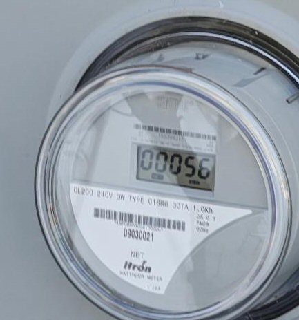
Shot up to 30 here from a low of 14, but has leveled off. I'm thinking I'm going to be on the warmer side of 32 for most of this event, but we'll see. Edit. Someone mentioned solar. I begin to ramp up the credits this time of year, but curretnly net imported 56 kWh since I had them installed a couple years ago. Looks like I may get a bill, but the guvna is supposedly going to discount it.
-
Is this going to be an ice event for MA pike north?