dallen7908
-
Posts
960 -
Joined
-
Last visited
Content Type
Profiles
Blogs
Forums
American Weather
Media Demo
Store
Gallery
Everything posted by dallen7908
-
April 8th Eclipse- Last Easy One To See In My Lifetime
dallen7908 replied to Interstate's topic in Mid Atlantic
Maybe clearer here? On July 22, 2028, a total solar eclipse will occur in Australia and New Zealand. The maximum duration of totality for this eclipse will be 5 minutes and 10 seconds. https://nationaleclipse.com/maps/map_07222028.html -
April 8th Eclipse- Last Easy One To See In My Lifetime
dallen7908 replied to Interstate's topic in Mid Atlantic
-
What Went Wrong in Winter 23-24/Base State/Will It Ever Snow Again??
dallen7908 replied to WxUSAF's topic in Mid Atlantic
Alfredo Ruiz-Barrados, the state climatologist just put out this summary of winter 2023-2024 You can access the winter Bulletin from the following link: https://www2.atmos.umd.edu/~climate/Bulletin/bulletin_mdsco_win24.pdf Points to highlight for winter 2023-24 are: 1) Winter 2023-24 was considerably warmer and wetter than normal, following warmer and wetter than normal December 2023 and January 2024, and a warmer and drier than normal February 2024. 2) The partial water year, October 2023 - February 2024, was above normal over most of the state (3-21% more than climatology), except for the southern half of Garret County (6-9% less than climatology) and western Allegany and western Charles counties (3-6% less than climatology). 3) Winter 2023-24 was the 5th warmest and 5th wettest among the 129 winters on record (1896-2024). 4) Significant, century-plus (1896-2024) warming trends exist throughout the state, particularly over the Piedmont corridor of Frederick, Montgomery, Howard, Carroll, Baltimore, Harford, and Cecil counties (3.4-3.6°F/century). 5) A significant increasing trend in statewide mean temperature (3.1°F/century) is coincident with a significant decreasing trend in statewide heating degree-days (-292.2°FDD) -
Late Feb/March Medium/Long Range Discussion
dallen7908 replied to WinterWxLuvr's topic in Mid Atlantic
-
Late Feb/March Medium/Long Range Discussion
dallen7908 replied to WinterWxLuvr's topic in Mid Atlantic
I occasionally stay at the YMCA of the Rockies in Granby when XC skiing at Devil's Thumb, Breckenridge, Frisco, or Snow Mountain Ranch. -
Late Feb/March Medium/Long Range Discussion
dallen7908 replied to WinterWxLuvr's topic in Mid Atlantic
Cold rain for the peak of the cherry blossoms - fun. -
Late Feb/March Medium/Long Range Discussion
dallen7908 replied to WinterWxLuvr's topic in Mid Atlantic
Here are the better than median March-April's for Baltimore T<=32 is days with mean T of 32 or below Snowfall in inches MECSb is (Daily_Snowfall - 5") D>1" is days with 1" or more of snow on the ground. While it's likely over for the lowlands, we have had some memorable months of March including 3 with > 20" of snow in the Baltimore area. It's hard to fathom that more than half of the days in March 1960 had mean temperatures of 32 or less. March 2014 also shows up - I remember my son chipping ice at a dock so they could begin the crew season. Baltimore Rank YEAR T<=32 Snow MECSb D>1" Points Grade PCTL 1 1959-1960 17.0 21.6 5.1 13.0 56.7 A++ 100 2 1941-1942 0.0 22.2 17.0 3.0 42.2 A- 99 3 1933-1934 8.0 14.0 1.0 10.0 33.0 B 98 4 1923-1924 0.0 21.4 5.8 4.0 31.2 B- 98 5 1992-1993 5.0 12.7 6.3 7.0 31.0 B- 97 6 1895-1896 5.0 13.8 1.0 9.0 28.8 B- 96 7 1961-1962 6.0 13.6 5.0 4.0 28.6 B- 95 8 1905-1906 10.0 11.2 0.0 7.0 28.2 B- 95 9 2013-2014 11.0 12.1 0.0 4.0 27.1 C+ 94 10 1913-1914 7.0 11.6 0.0 7.0 25.6 C+ 93 11 1940-1941 5.0 12.1 1.0 7.0 25.1 C+ 92 12 1908-1909 3.0 11.7 5.2 4.0 23.9 C 92 13 1936-1937 2.0 14.7 1.0 6.0 23.7 C 91 14 1977-1978 8.0 8.5 0.0 6.0 22.5 C 90 15 1899-1900 5.0 9.5 0.0 8.0 22.5 C 89 16 1957-1958 1.0 13.7 0.0 7.0 21.7 C 88 17 1963-1964 1.0 13.6 4.7 2.0 21.3 C 88 18 1942-1943 4.0 14.7 0.0 2.0 20.7 C 87 19 1943-1944 6.0 8.6 0.0 6.0 20.6 C 86 20 1915-1916 10.0 7.9 0.0 2.0 19.9 C- 85 Rank YEAR T<=32 Snow MECSb D>1" Points Grade PCTL 21 2014-2015 5.0 7.7 1.2 4.0 17.9 C- 85 22 1910-1911 5.0 8.4 1.2 3.0 17.6 C- 84 23 1911-1912 7.0 8.5 0.0 2.0 17.5 C- 83 24 1998-1999 4.0 7.6 0.0 5.0 16.6 C- 82 25 1995-1996 7.0 7.6 0.0 2.0 16.6 C- 82 26 1906-1907 4.0 7.7 1.6 3.0 16.3 C- 81 27 1955-1956 4.0 7.8 0.4 4.0 16.2 C- 80 28 1983-1984 6.0 6.1 0.0 4.0 16.1 C- 79 29 1930-1931 0.0 10.0 3.3 2.0 15.3 D+ 78 30 1922-1923 5.0 7.3 1.0 2.0 15.3 D+ 78 31 2016-2017 8.0 2.3 0.0 4.0 14.3 D+ 77 32 1951-1952 3.0 7.0 1.0 3.0 14.0 D+ 76 33 1968-1969 3.0 7.8 0.0 3.0 13.8 D+ 75 34 2008-2009 4.0 5.8 0.0 4.0 13.8 D+ 75 35 1979-1980 4.0 5.7 0.0 4.0 13.7 D+ 74 36 1964-1965 3.0 8.4 0.0 2.0 13.4 D+ 73 37 1931-1932 8.0 3.2 0.0 2.0 13.2 D+ 72 38 2002-2003 5.0 2.6 0.0 5.0 12.6 D+ 72 39 1975-1976 0.0 7.8 2.8 2.0 12.6 D+ 71 40 1914-1915 0.0 9.5 0.0 3.0 12.5 D+ 70 Rank YEAR T<=32 Snow MECSb D>1" Points Grade PCTL 41 1967-1968 3.0 5.3 0.0 2.0 10.3 D 69 42 1993-1994 3.0 4.2 0.0 3.0 10.2 D 68 43 1919-1920 4.0 2.4 0.0 3.0 9.4 D 68 44 1901-1902 2.0 5.0 0.0 2.0 9.0 D 67 45 2017-2018 0.0 6.7 0.0 2.0 8.7 D 66 46 1952-1953 3.0 3.6 0.0 2.0 8.6 D 65 47 2004-2005 5.0 0.4 0.0 3.0 8.4 D 65 48 1916-1917 2.0 5.2 0.0 1.0 8.2 D 64 49 1937-1938 1.0 5.0 0.0 2.0 8.0 D 63 50 1893-1894 1.0 5.0 0.0 2.0 8.0 D 62 51 1946-1947 1.0 2.8 0.0 4.0 7.8 D- 62 52 2006-2007 4.0 1.6 0.0 2.0 7.6 D- 61 53 1925-1926 7.0 0.6 0.0 0.0 7.6 D- 60 54 2018-2019 3.0 2.7 0.0 1.0 6.7 D- 59 55 1966-1967 4.0 2.5 0.0 0.0 6.5 D- 58 56 1939-1940 4.0 1.8 0.0 0.0 5.8 D- 58 57 1898-1899 3.0 1.6 0.0 1.0 5.6 D- 57 58 1932-1933 2.0 2.5 0.0 1.0 5.5 D- 56 59 2012-2013 0.0 3.2 0.0 2.0 5.2 D- 55 60 1974-1975 4.0 1.2 0.0 0.0 5.2 D- 55 Rank YEAR T<=32 Snow MECSb D>1" Points Grade PCTL 61 1997-1998 3.0 2.1 0.0 0.0 5.1 D- 54 62 1991-1992 5.0 0.0 0.0 0.0 5.0 D- 53 63 1985-1986 5.0 0.0 0.0 0.0 5.0 D- 52 64 1969-1970 3.0 1.9 0.0 0.0 4.9 D- 52 65 1989-1990 1.0 2.8 0.0 1.0 4.8 D- 51 66 1954-1955 3.0 1.2 0.0 0.0 4.2 D- 50 -
Late Feb/March Medium/Long Range Discussion
dallen7908 replied to WinterWxLuvr's topic in Mid Atlantic
Book that cabin in Arroostook County for March 15-18 and enjoying tracking the next few weeks. -
https://www.asasbriarcliff.com/the-ice-storm-of-1905 (Headlines from the winter with the most days with mean T < 32. )
-
Short Answer: Baltimore's winter has been better than 13% of winters (115th of 131) . There have been 10 days with a mean T of 32 or below, 11.3" of snow, and 9 days with > 1" of snow on the ground. Letter grade of D. DC's winter has been better than 17% of winters (110th of 131). There have been 9 days with a mean T of 32 or below, 8" of snow, and 8 days with >1" of snow on the ground. Letter grade of D-. The letter grades do not adjust for the different climatologies. baltimore Rank YEAR T<=32 Snow MECSb D>1" Points Grade PCTL 1 2009-2010 46.0 77.0 37.5 35.0 195.5 A++ 100 2 2002-2003 54.0 55.5 19.2 37.0 165.7 A+ 99 3 1904-1905 59.0 41.8 5.4 56.0 162.2 A+ 98 4 1960-1961 48.0 46.5 11.6 49.0 155.1 A 98 5 1995-1996 42.0 54.9 18.3 26.0 141.2 A- 97 6 1917-1918 58.0 34.9 6.0 39.0 137.9 A- 96 7 1898-1899 41.0 49.5 11.9 29.0 131.4 A- 95 8 1903-1904 68.0 23.9 1.0 34.0 126.9 B+ 95 9 1921-1922 30.0 44.8 19.5 28.0 122.3 B+ 94 10 1933-1934 43.0 35.6 5.4 36.0 120.0 B+ 93 11 1978-1979 38.0 42.5 13.4 25.0 118.9 B+ 92 12 1935-1936 44.0 30.1 2.0 41.0 117.1 B+ 92 13 1966-1967 40.0 40.9 11.1 25.0 117.0 B+ 91 14 1963-1964 41.0 38.2 10.1 24.0 113.3 B 90 15 1977-1978 56.0 25.8 3.4 22.0 107.2 B 89 16 1965-1966 41.0 32.8 9.1 20.0 102.9 B- 89 17 2013-2014 47.0 26.9 4.7 21.0 99.6 B- 88 18 1957-1958 39.0 29.3 9.3 21.0 98.6 B- 87 19 1981-1982 47.0 24.8 1.1 25.0 97.9 B- 86 20 1962-1963 53.0 17.8 0.0 27.0 97.8 B- 85 Rank YEAR T<=32 Snow MECSb D>1" Points Grade PCTL 21 1934-1935 28.0 29.5 7.5 32.0 97.0 B- 85 22 1982-1983 23.0 35.6 19.5 18.0 96.1 B- 84 23 1939-1940 36.0 21.8 1.0 37.0 95.8 B- 83 24 1944-1945 35.0 18.4 2.0 40.0 95.4 B- 82 25 1909-1910 37.0 30.7 5.2 22.0 94.9 B- 82 26 1924-1925 29.0 23.0 6.0 36.0 94.0 B- 81 27 1919-1920 46.0 16.8 0.0 30.0 92.8 B- 80 28 1999-2000 31.0 25.9 10.6 23.0 90.5 C+ 79 29 1910-1911 34.0 26.8 3.1 26.0 89.9 C+ 79 30 2015-2016 23.0 32.6 20.5 13.0 89.1 C+ 78 31 1947-1948 37.0 23.4 0.7 26.0 87.1 C+ 77 32 1976-1977 57.0 11.1 0.0 19.0 87.1 C+ 76 33 1945-1946 29.0 26.1 5.2 26.0 86.3 C+ 76 34 1929-1930 34.0 22.8 4.0 25.0 85.8 C+ 75 35 1986-1987 22.0 35.2 9.5 19.0 85.7 C+ 74 36 2014-2015 43.0 21.0 1.3 20.0 85.3 C+ 73 37 1906-1907 39.0 23.4 0.2 22.0 84.6 C+ 73 38 1894-1895 38.0 11.3 0.0 32.0 81.3 C+ 72 39 1961-1962 48.0 21.6 0.0 11.0 80.6 C+ 71 40 2003-2004 40.0 18.1 0.0 21.0 79.1 C+ 70 Rank YEAR T<=32 Snow MECSb D>1" Points Grade PCTL 41 1925-1926 30.0 22.3 5.1 21.0 78.4 C+ 69 42 1969-1970 40.0 19.1 1.1 18.0 78.2 C+ 69 43 2010-2011 47.0 14.4 2.6 14.0 78.0 C+ 68 44 1901-1902 47.0 8.4 0.6 22.0 78.0 C+ 67 45 1916-1917 34.0 23.1 0.0 20.0 77.1 C 66 46 1902-1903 32.0 19.8 0.0 25.0 76.8 C 66 47 1967-1968 41.0 18.1 3.4 14.0 76.5 C 65 48 1932-1933 20.0 25.4 8.5 20.0 73.9 C 64 49 1911-1912 40.0 14.4 0.0 19.0 73.4 C 63 50 1993-1994 40.0 13.1 0.0 20.0 73.1 C 63 51 1987-1988 31.0 20.4 2.5 18.0 71.9 C 62 52 1989-1990 31.0 14.5 0.0 24.0 69.5 C 61 53 1938-1939 23.0 18.9 3.6 23.0 68.5 C 60 54 1985-1986 40.0 15.6 0.0 12.0 67.6 C 60 55 1955-1956 43.0 10.3 0.0 14.0 67.3 C 59 56 1946-1947 23.0 22.3 4.9 16.0 66.2 C 58 57 2004-2005 35.0 17.6 0.2 13.0 65.8 C 57 58 2000-2001 47.0 8.7 0.0 9.0 64.7 C- 56 59 1896-1897 36.0 12.3 0.0 16.0 64.3 C- 56 60 1899-1900 33.0 16.2 1.0 13.0 63.2 C- 55 Rank YEAR T<=32 Snow MECSb D>1" Points Grade PCTL 61 1964-1965 37.0 10.2 0.0 15.0 62.2 C- 54 62 1973-1974 31.0 17.1 2.3 10.0 60.4 C- 53 63 1927-1928 25.0 15.9 9.3 10.0 60.2 C- 53 64 1900-1901 39.0 8.6 0.0 12.0 59.6 C- 52 65 1983-1984 38.0 8.4 0.0 13.0 59.4 C- 51 66 1942-1943 29.0 13.7 0.0 16.0 58.7 C- 50 67 1907-1908 28.0 16.8 0.6 13.0 58.4 C- 50 68 2005-2006 24.0 19.6 4.6 10.0 58.2 C- 49 69 1908-1909 16.0 21.8 0.9 19.0 57.7 C- 48 70 1953-1954 21.0 20.6 1.2 14.0 56.8 C- 47 71 1970-1971 39.0 11.0 0.0 5.0 55.0 C- 47 72 1913-1914 26.0 11.8 0.0 16.0 53.8 C- 46 73 1915-1916 27.0 13.2 0.0 13.0 53.2 C- 45 74 2017-2018 35.0 8.7 0.0 9.0 52.7 C- 44 75 2006-2007 33.0 9.4 0.0 10.0 52.4 C- 44 76 2018-2019 27.0 15.6 0.0 9.0 51.6 D+ 43 77 1984-1985 31.0 9.6 0.0 11.0 51.6 D+ 42 78 1958-1959 46.0 2.6 0.0 3.0 51.6 D+ 41 79 1996-1997 31.0 12.6 0.8 7.0 51.4 D+ 40 80 1928-1929 27.0 12.4 5.6 6.0 51.0 D+ 40 Rank YEAR T<=32 Snow MECSb D>1" Points Grade PCTL 81 1954-1955 34.0 8.9 0.0 8.0 50.9 D+ 39 82 1905-1906 23.0 13.8 0.7 13.0 50.5 D+ 38 83 1979-1980 35.0 8.9 0.0 6.0 49.9 D+ 37 84 2021-2022 22.0 14.0 1.8 12.0 49.8 D+ 37 85 1968-1969 37.0 10.8 0.0 1.0 48.8 D+ 36 86 1980-1981 41.0 4.3 0.0 3.0 48.3 D+ 35 87 1922-1923 26.0 13.9 0.0 8.0 47.9 D+ 34 88 1950-1951 35.0 6.2 0.0 6.0 47.2 D+ 34 89 1914-1915 31.0 6.8 0.0 9.0 46.8 D+ 33 90 1926-1927 27.0 10.7 0.0 9.0 46.7 D+ 32 91 1923-1924 24.0 13.0 1.3 8.0 46.3 D+ 31 92 1940-1941 23.0 11.8 0.0 11.0 45.8 D+ 31 93 1971-1972 24.0 13.5 0.0 8.0 45.5 D+ 30 94 1893-1894 23.0 12.1 0.0 10.0 45.1 D+ 29 95 2020-2021 20.0 10.9 0.0 14.0 44.9 D+ 28 96 1943-1944 21.0 11.7 0.0 12.0 44.7 D+ 27 97 1998-1999 25.0 7.6 0.0 11.0 43.6 D+ 27 98 2008-2009 37.0 3.3 0.0 3.0 43.3 D+ 26 99 1948-1949 9.0 19.9 2.0 11.0 41.9 D+ 25 100 1992-1993 26.0 11.7 0.0 4.0 41.7 D+ 24 Rank YEAR T<=32 Snow MECSb D>1" Points Grade PCTL 101 1959-1960 22.0 12.5 1.0 6.0 41.5 D+ 24 102 1956-1957 18.0 13.6 0.0 9.0 40.6 D+ 23 103 2007-2008 26.0 8.5 0.0 5.0 39.5 D+ 22 104 1994-1995 21.0 8.0 2.2 8.0 39.2 D+ 21 105 1988-1989 26.0 8.0 0.0 5.0 39.0 D+ 21 106 1991-1992 28.0 4.1 0.0 3.0 35.1 D 20 107 1897-1898 23.0 8.0 0.0 4.0 35.0 D 19 108 1975-1976 29.0 3.7 0.0 2.0 34.7 D 18 109 1920-1921 17.0 9.8 0.5 7.0 34.3 D 18 110 1972-1973 32.0 1.2 0.0 1.0 34.2 D 17 111 1974-1975 18.0 11.0 0.0 5.0 34.0 D 16 112 1990-1991 19.0 9.1 0.0 5.0 33.1 D 15 113 1936-1937 14.0 11.3 1.0 6.0 32.3 D 15 114 1951-1952 22.0 7.1 0.0 2.0 31.1 D 14 115 2023-2024 10.0 11.3 0.0 9.0 30.3 D 13 116 1941-1942 23.0 4.1 0.0 2.0 29.1 D 12 117 1895-1896 23.0 3.3 0.0 2.0 28.3 D 11 118 2012-2013 19.0 4.8 0.0 3.0 26.8 D 11 119 1937-1938 21.0 3.0 0.0 2.0 26.0 D 10 120 1912-1913 15.0 7.3 0.0 3.0 25.3 D- 9 Rank YEAR T<=32 Snow MECSb D>1" Points Grade PCTL 121 1952-1953 14.0 8.2 0.0 3.0 25.2 D- 8 122 1930-1931 18.0 3.6 0.0 1.0 22.6 D- 8 123 1918-1919 15.0 4.3 0.0 1.0 20.3 D- 7 124 2001-2002 14.0 2.3 0.0 2.0 18.3 D- 6 125 2019-2020 14.0 1.8 0.0 1.0 16.8 D- 5 126 2016-2017 16.0 0.7 0.0 0.0 16.7 D- 5 127 2011-2012 10.0 1.8 0.0 4.0 15.8 D- 4 128 1997-1998 9.0 1.1 0.0 0.0 10.1 F 3 129 1949-1950 9.0 0.5 0.0 0.0 9.5 F 2 130 2022-2023 7.0 0.2 0.0 0.0 7.2 F 2 131 1931-1932 5.0 1.7 0.0 0.0 6.7 F 1 dc Rank YEAR T<=32 Snow MECSb D>1" Points Grade PCTL 1 1904-1905 58.0 42.0 2.0 53.0 155.0 A 100 2 1917-1918 58.0 35.9 6.0 50.0 149.9 A 99 3 2009-2010 29.0 56.1 21.3 30.0 136.4 A- 98 4 1960-1961 42.0 40.3 8.1 44.0 134.4 A- 98 5 1898-1899 44.0 49.9 9.5 30.0 133.4 A- 97 6 1935-1936 47.0 33.0 9.4 29.0 118.4 B+ 96 7 1903-1904 67.0 20.2 0.6 30.0 117.8 B+ 95 8 1921-1922 32.0 40.0 16.0 28.0 116.0 B 95 9 2002-2003 37.0 40.3 9.4 26.0 112.7 B 94 10 1995-1996 36.0 40.8 10.1 23.0 109.9 B 93 11 1894-1895 43.0 24.7 1.0 39.0 107.7 B 92 12 1978-1979 33.0 37.7 10.2 23.0 103.9 B- 92 13 1966-1967 26.0 36.4 7.6 26.0 96.0 B- 91 14 1910-1911 36.0 32.6 0.0 26.0 94.6 B- 90 15 1939-1940 37.0 24.4 4.7 28.0 94.1 B- 89 16 1962-1963 46.0 20.3 0.7 27.0 94.0 B- 89 17 1933-1934 43.0 23.1 3.0 24.0 93.1 B- 88 18 1934-1935 28.0 31.9 7.0 26.0 92.9 B- 87 19 1919-1920 48.0 16.2 0.0 28.0 92.2 B- 86 20 1911-1912 42.0 18.0 1.1 30.0 91.1 B- 85 Rank YEAR T<=32 Snow MECSb D>1" Points Grade PCTL 21 1947-1948 44.0 23.5 0.4 22.0 89.9 C+ 85 22 1908-1909 22.0 35.1 8.7 23.0 88.8 C+ 84 23 1957-1958 31.0 29.8 14.0 12.0 86.8 C+ 83 24 1963-1964 31.0 27.0 3.7 25.0 86.7 C+ 82 25 1965-1966 30.0 28.4 9.1 18.0 85.5 C+ 82 26 1929-1930 36.0 20.4 6.5 22.0 84.9 C+ 81 27 1987-1988 30.0 24.6 7.8 22.0 84.4 C+ 80 28 1976-1977 48.0 11.1 0.0 24.0 83.1 C+ 79 29 1924-1925 34.0 20.2 0.0 28.0 82.2 C+ 79 30 1901-1902 46.0 10.6 0.0 22.0 78.6 C+ 78 31 1977-1978 43.0 14.4 0.0 18.0 75.4 C 77 32 1981-1982 28.0 22.3 1.4 22.0 73.7 C 76 33 1909-1910 38.0 17.0 0.0 18.0 73.0 C 76 34 1899-1900 32.0 19.9 4.0 17.0 72.9 C 75 35 1906-1907 37.0 20.5 0.0 15.0 72.5 C 74 36 1967-1968 36.0 18.4 1.9 16.0 72.3 C 73 37 1986-1987 14.0 31.1 7.7 17.0 69.8 C 73 38 1982-1983 15.0 27.6 13.0 13.0 68.6 C 72 39 1925-1926 29.0 17.9 4.4 17.0 68.3 C 71 40 1896-1897 39.0 16.2 0.0 13.0 68.2 C 70 Rank YEAR T<=32 Snow MECSb D>1" Points Grade PCTL 41 1945-1946 30.0 21.6 0.0 16.0 67.6 C 69 42 1907-1908 35.0 18.3 0.0 14.0 67.3 C 69 43 1900-1901 47.0 9.0 0.0 9.0 65.0 C 68 44 1893-1894 27.0 23.4 1.5 13.0 64.9 C- 67 45 1916-1917 36.0 15.8 0.0 12.0 63.8 C- 66 46 1989-1990 27.0 12.7 0.0 24.0 63.7 C- 66 47 1932-1933 20.0 22.8 6.5 14.0 63.3 C- 65 48 1999-2000 23.0 15.4 4.3 20.0 62.7 C- 64 49 1993-1994 33.0 9.2 0.0 20.0 62.2 C- 63 50 2013-2014 25.0 19.3 0.9 15.0 60.2 C- 63 51 1985-1986 30.0 15.4 0.0 14.0 59.4 C- 62 52 2015-2016 17.0 21.9 7.8 11.0 57.7 C- 61 53 1905-1906 26.0 18.4 0.4 12.0 56.8 C- 60 54 1946-1947 26.0 16.6 2.6 11.0 56.2 C- 60 55 1969-1970 29.0 14.0 0.0 13.0 56.0 C- 59 56 1915-1916 28.0 14.3 0.2 13.0 55.5 C- 58 57 1914-1915 36.0 8.5 0.0 11.0 55.5 C- 57 58 2003-2004 28.0 12.4 0.0 15.0 55.4 C- 56 59 1964-1965 30.0 11.7 0.0 13.0 54.7 C- 56 60 1938-1939 23.0 15.1 1.5 15.0 54.6 C- 55 Rank YEAR T<=32 Snow MECSb D>1" Points Grade PCTL 61 1913-1914 28.0 10.8 0.0 15.0 53.8 C- 54 62 2014-2015 26.0 13.4 0.0 13.0 52.4 C- 53 63 1961-1962 29.0 11.0 0.0 12.0 52.0 C- 53 64 1942-1943 28.0 12.7 0.0 11.0 51.7 D+ 52 65 1927-1928 24.0 13.2 5.5 9.0 51.7 D+ 51 66 1970-1971 34.0 10.3 0.0 5.0 49.3 D+ 50 67 1953-1954 17.0 18.0 2.9 11.0 48.9 D+ 50 68 2004-2005 28.0 11.7 0.0 9.0 48.7 D+ 49 69 1902-1903 31.0 8.2 0.0 9.0 48.2 D+ 48 70 1955-1956 36.0 7.3 0.0 4.0 47.3 D+ 47 71 2010-2011 27.0 9.9 0.0 10.0 46.9 D+ 47 72 1984-1985 27.0 10.3 0.0 9.0 46.3 D+ 46 73 2006-2007 29.0 7.2 0.0 10.0 46.2 D+ 45 74 1944-1945 34.0 8.2 0.0 4.0 46.2 D+ 44 75 1928-1929 31.0 8.0 2.5 4.0 45.5 D+ 44 76 1983-1984 29.0 6.8 0.0 9.0 44.8 D+ 43 77 2000-2001 30.0 7.2 0.0 6.0 43.2 D+ 42 78 1897-1898 29.0 8.0 0.0 6.0 43.0 D+ 41 79 1958-1959 35.0 4.9 0.0 3.0 42.9 D+ 40 80 1926-1927 25.0 8.8 0.0 9.0 42.8 D+ 40 Rank YEAR T<=32 Snow MECSb D>1" Points Grade PCTL 81 1979-1980 19.0 14.0 0.0 9.0 42.0 D+ 39 82 1950-1951 24.0 9.2 0.0 7.0 40.2 D+ 38 83 1956-1957 18.0 11.9 0.0 10.0 39.9 D+ 37 84 1971-1972 18.0 16.2 0.5 5.0 39.7 D+ 37 85 2018-2019 10.0 16.6 3.3 9.0 38.9 D 36 86 1973-1974 12.0 16.7 1.0 9.0 38.7 D 35 87 2021-2022 18.0 12.3 1.9 6.0 38.2 D 34 88 1923-1924 26.0 8.0 0.0 4.0 38.0 D 34 89 1922-1923 25.0 8.8 0.0 4.0 37.8 D 33 90 1940-1941 26.0 6.7 0.0 4.0 36.7 D 32 91 2005-2006 15.0 13.6 1.7 6.0 36.3 D 31 92 1943-1944 23.0 6.2 0.0 7.0 36.2 D 31 93 1920-1921 22.0 9.1 1.0 4.0 36.1 D 30 94 1980-1981 28.0 4.5 0.0 3.0 35.5 D 29 95 1994-1995 15.0 9.7 0.0 10.0 34.7 D 28 96 1954-1955 23.0 6.6 0.0 4.0 33.6 D 27 97 1968-1969 29.0 2.4 0.0 2.0 33.4 D 27 98 1912-1913 18.0 8.8 1.5 5.0 33.3 D 26 99 1948-1949 9.0 15.8 0.7 7.0 32.5 D 25 100 1937-1938 26.0 3.0 0.0 3.0 32.0 D 24 Rank YEAR T<=32 Snow MECSb D>1" Points Grade PCTL 101 1936-1937 17.0 9.2 0.6 5.0 31.8 D 24 102 2008-2009 26.0 2.0 0.0 2.0 30.0 D 23 103 1941-1942 25.0 2.1 0.0 2.0 29.1 D 22 104 1895-1896 25.0 1.5 0.0 2.0 28.5 D 21 105 2017-2018 22.0 3.3 0.0 3.0 28.3 D 21 106 1930-1931 22.0 2.5 0.0 3.0 27.5 D 20 107 1959-1960 15.0 7.2 0.0 5.0 27.2 D 19 108 1991-1992 16.0 6.6 0.0 4.0 26.6 D 18 109 1988-1989 19.0 5.3 0.0 2.0 26.3 D 18 110 2023-2024 9.0 8.0 0.0 8.0 25.0 D- 17 111 1951-1952 15.0 6.4 0.0 3.0 24.4 D- 16 112 1974-1975 6.0 12.5 0.0 5.0 23.5 D- 15 113 1998-1999 19.0 2.9 0.0 1.0 22.9 D- 15 114 1996-1997 12.0 6.7 0.0 4.0 22.7 D- 14 115 2020-2021 14.0 5.4 0.0 3.0 22.4 D- 13 116 1992-1993 15.0 5.1 0.0 2.0 22.1 D- 12 117 1990-1991 10.0 8.1 0.0 4.0 22.1 D- 11 118 2007-2008 13.0 4.9 0.0 4.0 21.9 D- 11 119 1975-1976 19.0 1.4 0.0 1.0 21.4 D- 10 120 1972-1973 21.0 0.1 0.0 0.0 21.1 D- 9 Rank YEAR T<=32 Snow MECSb D>1" Points Grade PCTL 121 1918-1919 16.0 3.3 0.0 0.0 19.3 D- 8 122 1952-1953 8.0 5.2 0.0 2.0 15.2 D- 8 123 2012-2013 11.0 1.5 0.0 0.0 12.5 F 7 124 2016-2017 9.0 1.4 0.0 1.0 11.4 F 6 125 2001-2002 6.0 3.2 0.0 1.0 10.2 F 5 126 2011-2012 6.0 2.0 0.0 1.0 9.0 F 5 127 1949-1950 8.0 0.3 0.0 0.0 8.3 F 4 128 2019-2020 6.0 0.6 0.0 0.0 6.6 F 3 129 2022-2023 5.0 0.4 0.0 0.0 5.4 F 2 130 1931-1932 4.0 1.0 0.0 0.0 5.0 F 2 131 1997-1998 2.0 0.1 0.0 0.0 2.1 F 1
-
Nordic Discussion: Lapland Lake - and who would those people be? February 13 Temperatures have stabilized and we are making good progress repairing damage from recent warm weather and rain. Today we expect to have approximately 10K of XC ski trail open. Lake Trail and Olavin Uni will be open with fresh grooming and power tilled granular surface. Vasa and Karhu via Leilan Latu will be open with surface groomed yesterday, they will be firm in the morning softening a bit as temperatures rise into the mid 30s. No fresh snow here this morning – the storm tracked way south where some people don’t even want the snow. Forecasts look very good for a moderate snow here Thursday night, right in time to freshen things up for the holiday weekend!
-
Short answer: Through January 31, it is better than 31% of winters but only earns a D+ grade. We've had 10 days with mean temperatures of 32 or less, 9.1" of snow, no big storms, and 8 days with 1" or more of snow on the ground The subjective rating system is (#Days with T<+32) + Snowfall (inches) + MECs bonus (1 point for each inch a 1-day snowfall exceeds 5") + (#Days with >= 1" on the ground) baltimore Rank YEAR T<=32 Snow MECSb D>1" Points Grade PCTL 1 1917-1918 47.0 32.5 6.0 27.0 112.5 A++ 100 2 1904-1905 39.0 35.1 5.4 31.0 110.5 A++ 99 3 1960-1961 38.0 30.1 7.0 32.0 107.1 A++ 98 4 1903-1904 48.0 21.4 1.0 27.0 97.4 A+ 98 5 1921-1922 22.0 40.1 19.5 14.0 95.6 A 97 6 1995-1996 29.0 35.9 13.5 15.0 93.4 A 96 7 1924-1925 25.0 23.0 6.0 30.0 84.0 A- 95 8 2009-2010 29.0 27.0 12.0 13.0 81.0 A- 95 9 1939-1940 32.0 16.5 1.0 30.0 79.5 B+ 94 10 1976-1977 46.0 11.1 0.0 19.0 76.1 B+ 93 11 1909-1910 27.0 25.5 5.2 18.0 75.7 B+ 92 12 2015-2016 15.0 30.0 20.5 10.0 75.5 B+ 92 13 1944-1945 29.0 14.4 2.0 30.0 75.4 B+ 91 14 1981-1982 35.0 17.2 1.1 21.0 74.3 B+ 90 15 1962-1963 34.0 15.7 0.0 24.0 73.7 B+ 89 16 1963-1964 29.0 20.0 5.8 18.0 72.8 B+ 89 17 1929-1930 29.0 19.4 4.0 20.0 72.4 B+ 88 18 2002-2003 36.0 15.0 2.4 15.0 68.4 B 87 19 1999-2000 21.0 23.3 10.6 12.0 66.9 B 86 20 1934-1935 22.0 21.3 7.5 15.0 65.8 B 85 Rank YEAR T<=32 Snow MECSb D>1" Points Grade PCTL 21 1989-1990 27.0 14.5 0.0 24.0 65.5 B 85 22 1910-1911 26.0 17.8 2.5 19.0 65.3 B 84 23 1938-1939 20.0 18.6 3.6 23.0 65.2 B 83 24 1969-1970 33.0 15.1 1.1 15.0 64.2 B 82 25 2003-2004 30.0 18.0 0.0 16.0 64.0 B 82 26 1967-1968 31.0 15.5 3.4 13.0 62.9 B- 81 27 1987-1988 22.0 20.2 2.5 18.0 62.7 B- 80 28 1935-1936 26.0 15.3 0.0 21.0 62.3 B- 79 29 2010-2011 37.0 11.9 2.6 10.0 61.5 B- 79 30 1955-1956 37.0 9.9 0.0 14.0 60.9 B- 78 31 1966-1967 22.0 20.8 6.0 12.0 60.8 B- 77 32 1945-1946 23.0 15.0 2.6 20.0 60.6 B- 76 33 1965-1966 27.0 21.4 6.0 6.0 60.4 B- 76 34 1986-1987 16.0 25.1 8.4 9.0 58.5 B- 75 35 1977-1978 34.0 13.5 0.0 11.0 58.5 B- 74 36 1911-1912 25.0 14.4 0.0 18.0 57.4 B- 73 37 1919-1920 34.0 7.2 0.0 16.0 57.2 B- 73 38 2013-2014 31.0 12.7 0.1 13.0 56.8 B- 72 39 1902-1903 26.0 13.8 0.0 17.0 56.8 B- 71 40 1916-1917 22.0 16.4 0.0 16.0 54.4 C+ 70 Rank YEAR T<=32 Snow MECSb D>1" Points Grade PCTL 41 1896-1897 29.0 10.9 0.0 14.0 53.9 C+ 69 42 1983-1984 32.0 8.4 0.0 13.0 53.4 C+ 69 43 1908-1909 15.0 18.5 0.9 18.0 52.4 C+ 68 44 2000-2001 39.0 5.0 0.0 7.0 51.0 C+ 67 45 1898-1899 26.0 15.6 0.0 9.0 50.6 C+ 66 46 1953-1954 16.0 19.6 1.2 13.0 49.8 C+ 66 47 1927-1928 18.0 15.8 9.3 6.0 49.1 C+ 65 48 1947-1948 23.0 13.0 0.0 12.0 48.0 C+ 64 49 1993-1994 30.0 7.8 0.0 10.0 47.8 C 63 50 1961-1962 32.0 12.4 0.0 3.0 47.4 C 63 51 1964-1965 23.0 9.1 0.0 14.0 46.1 C 62 52 1970-1971 30.0 10.4 0.0 5.0 45.4 C 61 53 1942-1943 23.0 11.6 0.0 10.0 44.6 C 60 54 1932-1933 12.0 14.8 5.5 12.0 44.3 C 60 55 1958-1959 37.0 2.6 0.0 3.0 42.6 C 59 56 2017-2018 28.0 6.5 0.0 8.0 42.5 C 58 57 1984-1985 23.0 9.2 0.0 10.0 42.2 C 57 58 2021-2022 16.0 13.3 1.8 11.0 42.1 C 56 59 1957-1958 21.0 11.0 2.8 6.0 40.8 C 56 60 2004-2005 24.0 7.6 0.0 8.0 39.6 C- 55 Rank YEAR T<=32 Snow MECSb D>1" Points Grade PCTL 61 1980-1981 32.0 4.3 0.0 3.0 39.3 C- 54 62 1901-1902 28.0 7.4 0.6 3.0 39.0 C- 53 63 1925-1926 23.0 6.2 0.0 9.0 38.2 C- 53 64 1894-1895 20.0 5.0 0.0 13.0 38.0 C- 52 65 1914-1915 25.0 5.2 0.0 7.0 37.2 C- 51 66 2018-2019 20.0 9.5 0.0 7.0 36.5 C- 50 67 1950-1951 27.0 5.5 0.0 4.0 36.5 C- 50 68 1906-1907 22.0 7.5 0.0 7.0 36.5 C- 49 69 1998-1999 19.0 7.0 0.0 10.0 36.0 C- 48 70 2014-2015 23.0 6.4 0.0 6.0 35.4 C- 47 71 1933-1934 19.0 8.3 0.0 8.0 35.3 C- 47 72 1956-1957 16.0 10.9 0.0 8.0 34.9 C- 46 73 2008-2009 29.0 2.7 0.0 3.0 34.7 C- 45 74 1996-1997 27.0 5.5 0.0 2.0 34.5 C- 44 75 1968-1969 30.0 4.4 0.0 0.0 34.4 C- 44 76 1926-1927 27.0 2.8 0.0 4.0 33.8 C- 43 77 1973-1974 18.0 9.5 1.0 5.0 33.5 C- 42 78 1978-1979 18.0 9.4 0.0 6.0 33.4 C- 41 79 1900-1901 18.0 6.5 0.0 7.0 31.5 D+ 40 80 1951-1952 22.0 7.1 0.0 2.0 31.1 D+ 40 Rank YEAR T<=32 Snow MECSb D>1" Points Grade PCTL 81 1985-1986 26.0 2.6 0.0 2.0 30.6 D+ 39 82 2007-2008 19.0 7.2 0.0 4.0 30.2 D+ 38 83 1899-1900 20.0 3.2 0.0 7.0 30.2 D+ 37 84 1954-1955 26.0 2.7 0.0 1.0 29.7 D+ 37 85 1982-1983 14.0 8.4 1.7 5.0 29.1 D+ 36 86 1897-1898 16.0 8.0 0.0 4.0 28.0 D+ 35 87 1988-1989 16.0 6.9 0.0 5.0 27.9 D+ 34 88 1943-1944 15.0 5.9 0.0 7.0 27.9 D+ 34 89 1915-1916 17.0 5.9 0.0 5.0 27.9 D+ 33 90 1948-1949 7.0 11.0 1.8 8.0 27.8 D+ 32 91 1975-1976 24.0 2.4 0.0 1.0 27.4 D+ 31 92 2023-2024 10.0 9.1 0.0 8.0 27.1 D+ 31 93 1990-1991 13.0 9.0 0.0 5.0 27.0 D+ 30 94 1922-1923 13.0 9.6 0.0 4.0 26.6 D+ 29 95 1905-1906 10.0 6.9 0.7 9.0 26.6 D+ 28 96 2005-2006 14.0 6.5 0.0 5.0 25.5 D+ 27 97 1979-1980 16.0 5.1 0.0 4.0 25.1 D+ 27 98 1940-1941 12.0 7.0 0.0 6.0 25.0 D+ 26 99 1991-1992 21.0 2.2 0.0 1.0 24.2 D+ 25 100 1952-1953 12.0 8.2 0.0 3.0 23.2 D 24 Rank YEAR T<=32 Snow MECSb D>1" Points Grade PCTL 101 1946-1947 9.0 9.8 0.0 4.0 22.8 D 24 102 1907-1908 13.0 4.7 0.0 5.0 22.7 D 23 103 1972-1973 21.0 0.0 0.0 0.0 21.0 D 22 104 2020-2021 12.0 5.9 0.0 2.0 19.9 D 21 105 1895-1896 17.0 1.2 0.0 1.0 19.2 D 21 106 2006-2007 16.0 0.9 0.0 2.0 18.9 D 20 107 1930-1931 15.0 2.8 0.0 1.0 18.8 D 19 108 1974-1975 10.0 5.5 0.0 3.0 18.5 D 18 109 1937-1938 15.0 2.2 0.0 1.0 18.2 D 18 110 1893-1894 14.0 1.2 0.0 3.0 18.2 D 17 111 1941-1942 13.0 3.1 0.0 2.0 18.1 D 16 112 1928-1929 16.0 1.1 0.0 1.0 18.1 D 15 113 1959-1960 14.0 1.8 0.0 1.0 16.8 D 15 114 1923-1924 12.0 2.4 0.0 2.0 16.4 D 14 115 2001-2002 12.0 2.3 0.0 2.0 16.3 D 13 116 2012-2013 8.0 4.3 0.0 3.0 15.3 D- 12 117 1971-1972 12.0 2.1 0.0 1.0 15.1 D- 11 118 1992-1993 11.0 2.9 0.0 0.0 13.9 D- 11 119 2019-2020 11.0 1.8 0.0 1.0 13.8 D- 10 120 2016-2017 13.0 0.7 0.0 0.0 13.7 D- 9 Rank YEAR T<=32 Snow MECSb D>1" Points Grade PCTL 121 2011-2012 9.0 1.3 0.0 3.0 13.3 D- 8 122 1918-1919 12.0 1.3 0.0 0.0 13.3 D- 8 123 1920-1921 12.0 1.1 0.0 0.0 13.1 D- 7 124 1912-1913 5.0 4.9 0.0 3.0 12.9 D- 6 125 1994-1995 10.0 0.5 0.0 0.0 10.5 D- 5 126 1997-1998 8.0 1.1 0.0 0.0 9.1 D- 5 127 1913-1914 9.0 0.0 0.0 0.0 9.0 D- 4 128 1936-1937 6.0 2.8 0.0 0.0 8.8 D- 3 129 2022-2023 5.0 0.0 0.0 0.0 5.0 F 2 130 1931-1932 2.0 1.7 0.0 0.0 3.7 F 2 131 1949-1950 3.0 0.5 0.0 0.0 3.5 F 1
-
Jan/Early Feb Medium/Long Range Discussion Part 3
dallen7908 replied to WinterWxLuvr's topic in Mid Atlantic
I keep reminding myself that during El Niño years, February 8th is apparently the date when we (a mean of several Mid-Atlantic sites) are half through with our snow for the winter. -
Jan/Early Feb Medium/Long Range Discussion Part 3
dallen7908 replied to WinterWxLuvr's topic in Mid Atlantic
I should probably put something together but I was just going with the following: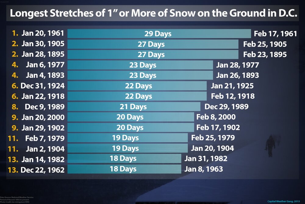
-
Jan/Early Feb Medium/Long Range Discussion Part 3
dallen7908 replied to WinterWxLuvr's topic in Mid Atlantic
Different climate up your way; the longest recorded stretch with snow on the ground in DC is 29 days from Jan 20 to Feb 17, 1961 -
Jan 19th Snow on Snow: the this always works until it doesn't thread
dallen7908 replied to psuhoffman's topic in Mid Atlantic
I know. My first thought was that (that) was a lower bound. They need to change the title to something less judgmental. I also find it amusing how excited we get when the model spits out an additional 0.05" of precipitation for our snow-deprived backyards. -
You'll live in a different world. Gorgeous here. Dog sunbathing on our south-facing deck. 41.3 degrees.
-
Jan Medium/Long Range Disco 2: Total Obliteration is Coming
dallen7908 replied to Jebman's topic in Mid Atlantic
... but this one will work because it's right on the edge of the January 20th - February 20th EL Nino window for big snows! The GGEM does a pretty good job of predicting the 500 hPa pattern ... but yeah the solutions it shows at the surface rarely verify without support from other models. -
Jan 15-16 Storm Threat Thread: Do we finally win or get Saltburned?
dallen7908 replied to H2O's topic in Mid Atlantic

- 425 replies
-
- 4
-

-

-
- jinx
- kiss of death
- (and 3 more)
-
Jan Medium/Long Range Disco 2: Total Obliteration is Coming
dallen7908 replied to Jebman's topic in Mid Atlantic
Hopefully the EPS and its parent will re-join the party later today
-
Jan Medium/Long Range Disco 2: Total Obliteration is Coming
dallen7908 replied to Jebman's topic in Mid Atlantic
Go to Tropical Tidbits Northern Hemisphere Projection GFS 500mb Geopotential height and MSLP Click animate and you can examine how the MSLP tracks the height pattern -
Jan Medium/Long Range Disco 2: Total Obliteration is Coming
dallen7908 replied to Jebman's topic in Mid Atlantic
If you really want us to stop worrying after each run, you should have stopped after one sentence! (But I know what you mean). -
Jan Medium/Long Range Disco 2: Total Obliteration is Coming
dallen7908 replied to Jebman's topic in Mid Atlantic
As several have pointed some of the model storms are still ongoing at the end of the 06 UTC EPS run
-
Jan Medium/Long Range Disco 2: Total Obliteration is Coming
dallen7908 replied to Jebman's topic in Mid Atlantic
February 24 of that month when 0.58" fell at BWI was the only day with more than 0.03" of precipitation. https://weatherspark.com/h/m/147101/1977/2/Historical-Weather-in-February-1977-at-Baltimore-Washington-International-Airport-Maryland-United-States -
Jan Medium/Long Range Disco: Winter is coming
dallen7908 replied to stormtracker's topic in Mid Atlantic
Yes, it's nice to see that the 50th PCTL highs for the DC/Baltimore area from the 00 UTC EPS are sub-40 from January 14 through the 22nd. When cold air is present a minor system could pop up in the medium-range and break the 1" drought at DCA and BWI. That said, I'm still hoping to reel in a big dog detected in the long range.