dallen7908
-
Posts
919 -
Joined
-
Last visited
Content Type
Profiles
Blogs
Forums
American Weather
Media Demo
Store
Gallery
Everything posted by dallen7908
-
3 of the 31 GEFS members give us measurable snow during that period with one of the members giving us 2 1/2". Let's watch this improve with time (I hope) 25% of the EPS members show a near-zero or slightly positive PNA by late on the 8th!
-
CPC is skeptical that any pattern change will be more than transient. After seasonal temperatures in week 2 (January 1-8), their 3-4 week outlook for January 8-21 (see link and below) suggests that the southeast ridge will be a bit muted in week 3 before strengthening once again in week 4. No reason for too much concern as they only give us a 55% chance of above normal (1990-2020) temperatures, which may be closer to a coin flip with respect to a mean centered on this year. https://www.cpc.ncep.noaa.gov/products/predictions/WK34/ "A manual blend of dynamical and statistical model guidance favors a continuation of the negative PNA and negative NAO patterns, showing up as a pair of ridges south of the Aleutians and over Greenland, and troughs over the West and the North Atlantic. A persistent ridge also remains over the Southeast, which is consistent with La Nina conditions. While the statistical guidance depicts more troughing and cold air intrusion into the eastern US, these tools are based on a more progressive and canonical MJO evolution than what is currently observed."
-
Yes it showed up on my YouTube feed. Hard to beat the 1993 storm in this area - didn't quite get to a foot of snow but being able to walk across the backyard on top of the snow/sleet drifts made up for it
-
While stretching this morning, I watched a fascinating documentary called the Storm of the Century: the Blizzard of 1949 by Wyoming PBS - a must watch if you love snow
-
Forecast highs from the GEFS and EPS for January 3-5th are predicted to be in the upper 30s for many of us. With above normal temperatures likely for the southeast, waves moving along the strong thermal gradient could be interesting - and maybe we'll be on the "right" side.
-
I'd feel quite a bit more optimistic if that was the model median as opposed to mean; I've never understood why they don't plot that instead
-
Perhaps in early January as the -NAO weakens while the EPO trends or remains slightly negative - certainly some precipitation chances
-
December 2021 Medium/Long Range Discussion Thread
dallen7908 replied to North Balti Zen's topic in Mid Atlantic
I know what follows is perambulating banter ... ... this reminded me of 7th grade when I was waiting at the scorers table to enter the game for the first time with 7 seconds left. Alas .. the coach did not call time out. The pitfall of being a 4th string point guard. ... but hey it's mid-December the equivalent of the 2nd inning if you'll excuse my shifting to a baseball analogy. I mean the atmosphere is like a tub of water right - at some point the cold water is bound to slosh our way - and we'll have our window... but for now all we can do is ooh-and-ah about a stout hour 360 -NAO, hope that the MJO will quit tarryng in 7 and head into 8, and look forward to how good the pattern 15-days past the 360-hour ensemble mean should be if past history during similar patterns holds. Keep the faith: with only a bit of luck by mid-January, a few moisture-starved systems will pass near us and we will be able to return to worrying about the exact location of the rain/snow line. -
December 2021 Medium/Long Range Discussion Thread
dallen7908 replied to North Balti Zen's topic in Mid Atlantic
Crazy of him to event mention an "event" that would be 10-days away beginning on XMAS eve; an operational model has no skill 10-days out and ensembles are only useful for guidance as to whether or not there will be an east-coast event. But I couldn't resist: 5 of the 51 EPS members show snow on the 24th or 25th- with a maximum amount of ~1". -
December 2021 Medium/Long Range Discussion Thread
dallen7908 replied to North Balti Zen's topic in Mid Atlantic
Last 4 runs of the EURO UL: 12 UT today. UR: 00 UT today LL: 12 UT yesterday; LR: 00 UT yesterday Next Monday's possible storm goes poof - for now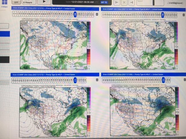
-
December 2021 Medium/Long Range Discussion Thread
dallen7908 replied to North Balti Zen's topic in Mid Atlantic
Whenever PSU goes on this rant, it always reminds me of skill score. A skill score measures the accuracy of a forecast with reference to the accuracy of a standard forecast. The standard forecast is usually but not always a forecast that is available to a forecaster, and which does not require any effort or knowledge on his part to prepare. For example, a forecast which consists of the climatological average temperature for a particular station for each day can be obtained from climatological tables and doesn't require any knowledge of the current weather situation to prepare. More significant digits, more ensembles, or a better model might help (a very little) but this doesn't look encouraging for us low landers..thumb.png.009c99c7543ec64f5a41983fe13ce93c.png)
-
December 2021 Medium/Long Range Discussion Thread
dallen7908 replied to North Balti Zen's topic in Mid Atlantic
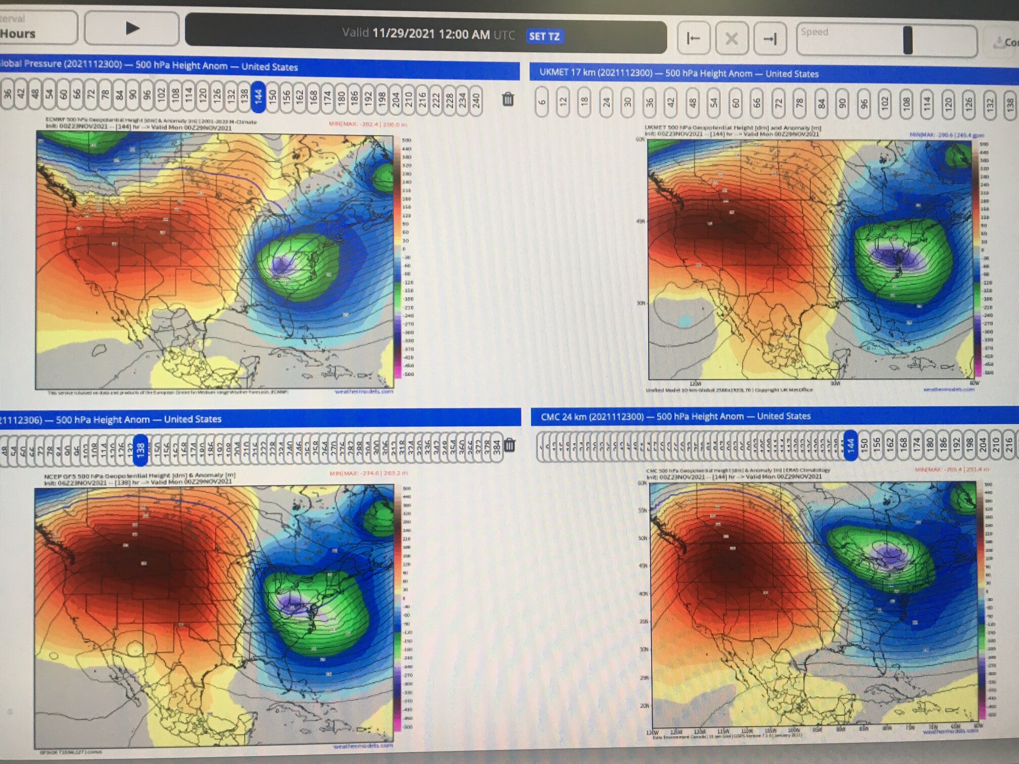
06 UT Thursday morning. EURO is in UL, GFS UR, CMC LR, UKMET LL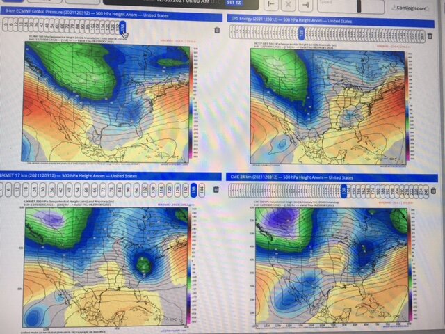
-
December 2021 Medium/Long Range Discussion Thread
dallen7908 replied to North Balti Zen's topic in Mid Atlantic
A blurry look at next Wednesday's system. Clockwise from upper left: EURO, GFS, CMC, and UKMET. Hopefully, the UKMET is on to something ...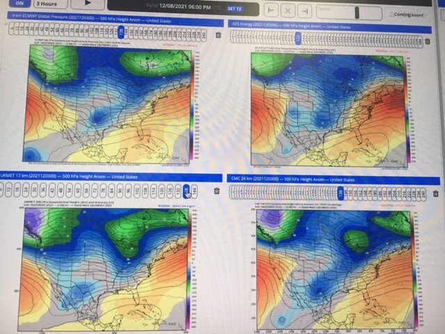
-
December 2021 Medium/Long Range Discussion Thread
dallen7908 replied to North Balti Zen's topic in Mid Atlantic
At this time ... Very limited ensemble support from the 06 UT GEFS for a West Virginia/ Pennsylvania storm next Monday; no support for the DC area. No operational support. Plots shown at 12Z on Monday: UL EURO, UR GFS, LL CMC, LR Korean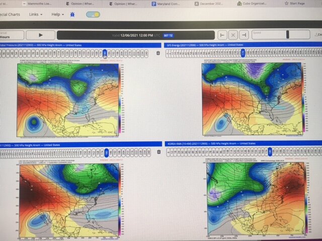
-
December 2021 Medium/Long Range Discussion Thread
dallen7908 replied to North Balti Zen's topic in Mid Atlantic
Here is a preprint of a recent un-reviewed article on the impact of SSW on European winter weather. Worth the skim. https://eartharxiv.org/repository/view/2206/ -
December 2021 Medium/Long Range Discussion Thread
dallen7908 replied to North Balti Zen's topic in Mid Atlantic
Monday's "event". ECMWF, UKMET, GFS, and CMC
-
December 2021 Medium/Long Range Discussion Thread
dallen7908 replied to North Balti Zen's topic in Mid Atlantic
I don't know about that but these type of patterns must excite the Ottawa weenies - visions of another 200 cm winter -
Any thoughts on the pros and cons of various premium weather sites. Which would make sense for personal tracking of snow (or in my case usually mixed events). WeatherBELL.com weather models.com accuweather.com etc. Other I have an advanced degree in meteorology but this would be for personal use; specifically tracking winter storms via ensembles. I've used weather models.com in the past and may continue to do so but am wondering if there are advantages to going with WeatherBELL.com etc. I believe WeatherBELL.com is a bit more expensive $25/mo vs. $15/mo for weather models.com. I suspect weatherbell.com gets their ECMWF output quicker but am uncertain. I've used accuweather in the past when our Department had an account.
-
Graupel in College Park too (not much)
-
What's stunning to me is that we've been tracking nearly non-stop this winter. Before this current period, a harbinger of spring?, the only comparable period with nothing to track was the last 10 or so days of December and that period ended earlier than expected. The EPS did an amazing job of sniffing out medium-range threats (European Center for MEDIUM Range Weather Forecasting). Unfortunately, their decision to add 06 and 18 UT runs to provide boundary conditions for (European) mesoscale models proved to be justified and necessary; the Euro did poorly within 3-days on the one metric that matters to many in this forum. The NAM was annoyingly right for the wrong reasons beyond 48 hours but an important tool within 48-hours. During the 2020-21 winter, those warm layers are insidious/surreptitious/stealthy (insert your favorite adjective) and if one model shows a warm layer in Fredericksburg prepare for sleet in Frederick. Snow forecasts from the GFSv16 were useless. Hopefully, this can be fixed with a few tweaks to the diagnostics. Last I checked snow amount wasn't a prognostic variable! Hopefully, this current period is short and we'll be tracking a last hurrah (for our northern and western members?) soon.
-
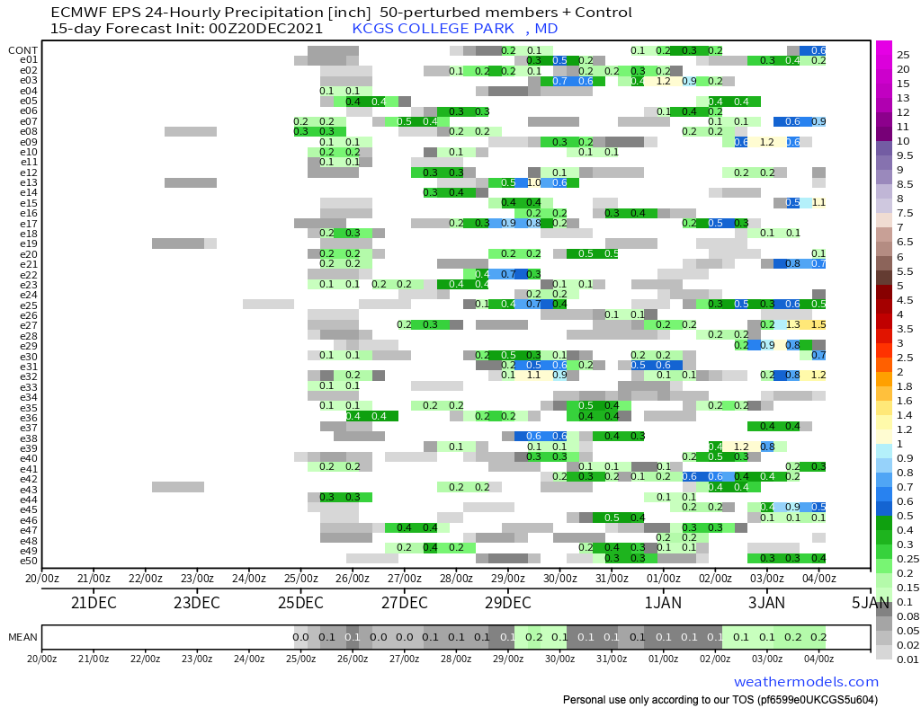
For once, the GEFSv12 and EPS members are (likely) not overestimating the DC-area's snow chances over the next 10-15 days. Keep in mind that the EPS values are shown every 12-hours for 24-hour periods so divide by 2. The values for the GFS are total for the entire period.


-
It's still February! I'm at 38.97519N 76.93796W. Sadly further south than even the CP airport.
-
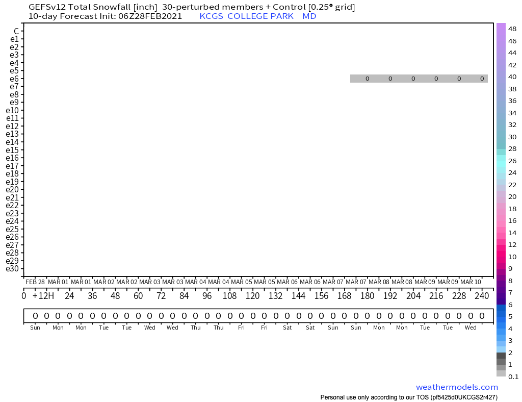
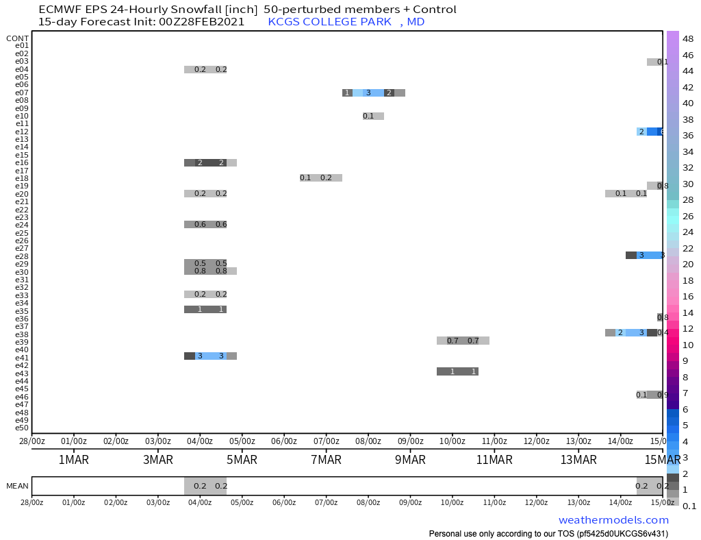
00 UT EPS mean snow fall for College Park over the next 15 days is 1", likely an inch below climatology. To put it another way, the EPS "predicts" that 4% of a predicted 2.3" of precipitation during the next 15 days will be snow/sleet. Pathetic but if forced to put down money I'd take the ... The EPS mean (median) snow/sleet for the February 28 storm is 0.1 (0.0)" The same values for the March 3/4 storm are 0.4 (0.0)". One ensemble member shows a HECS March 10-12. The 18+" from that storm is the main contributor to the 1" mean. Could be fun.
-
12/16 0.6" 1/25 0.4" 1/31 2.0" 2/1 0.25" 2/2 1.25" 2/7 0.1" 2/10-2/11 0.4" 2/18 0.8" 2/19 0.2" 2/22 0.2" 6.2" for the season (College Park)
-
0.2"* in College Park - before changing back to sleet and now rain/sleet mix *Its kind of silly but I have a ruler on the ledge of the fireplace and run out and measure as soon as the transition(s) begin All about maximizing one's snow totals Now over 6" for the winter - close to 50% of median

.png.3e7895ce9796d546e0f514a5e295935b.png)