pen_artist
-
Posts
52 -
Joined
-
Last visited
About pen_artist

Recent Profile Visitors
1,348 profile views


-
Got a bit greedy with how last year's spring went (if I recall a good amount of 60's and 70's?) and forgot this weather is very much on par for a typical April here...just a few more weeks
-
4/2-4/3 Potential Major Severe WX Outbreak
pen_artist replied to Geoboy645's topic in Lakes/Ohio Valley
More of a weenie thing since storms may not be able to take advantage of it but latest HRRR 03z showing insane STP values of 12.7 near Will, Kane, Kendall counties. -
2025 Short Range Severe Weather Discussion
pen_artist replied to Chicago Storm's topic in Lakes/Ohio Valley
Not a bad run on 18z HRRR. Timing looking optimal for Chicago area and some period of discrete-ness in storms. Dews in mid 50s with temps around low to mid 60's. -
March 14-15 Severe Weather Outbreak
pen_artist replied to HillsdaleMIWeather's topic in Lakes/Ohio Valley
Will get new outlook in a little over 35 minutes so we shall see. For those interested, Convective Chronicles just added new video highlighting the threats. -
March 14-15 Severe Weather Outbreak
pen_artist replied to HillsdaleMIWeather's topic in Lakes/Ohio Valley
Chasing in true midwestern fashion! -
March 14-15 Severe Weather Outbreak
pen_artist replied to HillsdaleMIWeather's topic in Lakes/Ohio Valley
LOT does mention a few tornadoes being possible tomorrow night but really looking like an intense wind event regardless of convection. Gusts around 60mph not out of possibility. -
March 14-15 Severe Weather Outbreak
pen_artist replied to HillsdaleMIWeather's topic in Lakes/Ohio Valley
Am I wrong in assuming we will experience a decent wind threat in the Chicago area tomorrow night? Full disclosure, I am rather novice with forecasting so mainly go off what others share in the forums but I am surprised there hasn't been as much activity here. Just curious, thank you in advance. -
2024 Short/Medium Range Severe Weather Discussion
pen_artist replied to Chicago Storm's topic in Lakes/Ohio Valley
Just got put under the DuPage TOR warning. Wind really gusting now. Getting to safe spot. -
Just got the upgrade to enhanced a bit west of Chicagoland. Fully expecting the 60% hatched tor next update, high risk next update
-
Adding on to the great weather recently trend, enjoyed a beautiful day at Wrigley today watching Cubs pull out a win at the very end
-
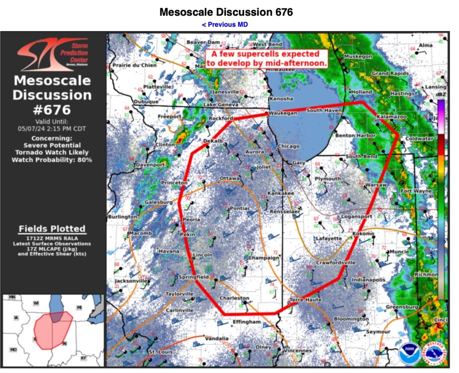
Mesoscale disco out highlighting tornado watch incoming for NE & E IL, N IN, and extreme SW MI.
-
Curious what the 00z HRRR will show. 18z HRR showing around 18z Saturday a bit more of a decent environment entering into N IL/S WI. Has anyone had any thoughts on this threat for Chicago area?
-
Most recent HRRR run (20z) returning to showing some discrete cells in Chicagoland between 6PM-11PM.
-
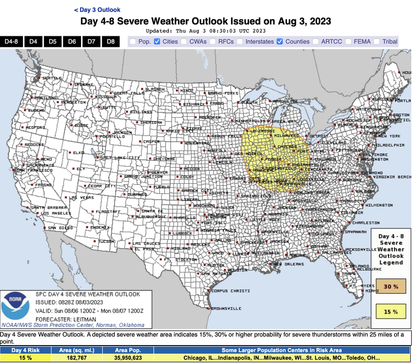
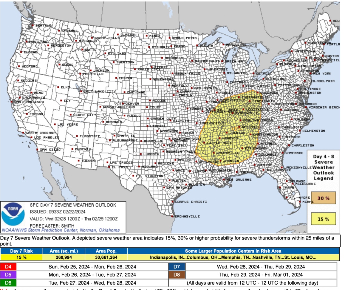
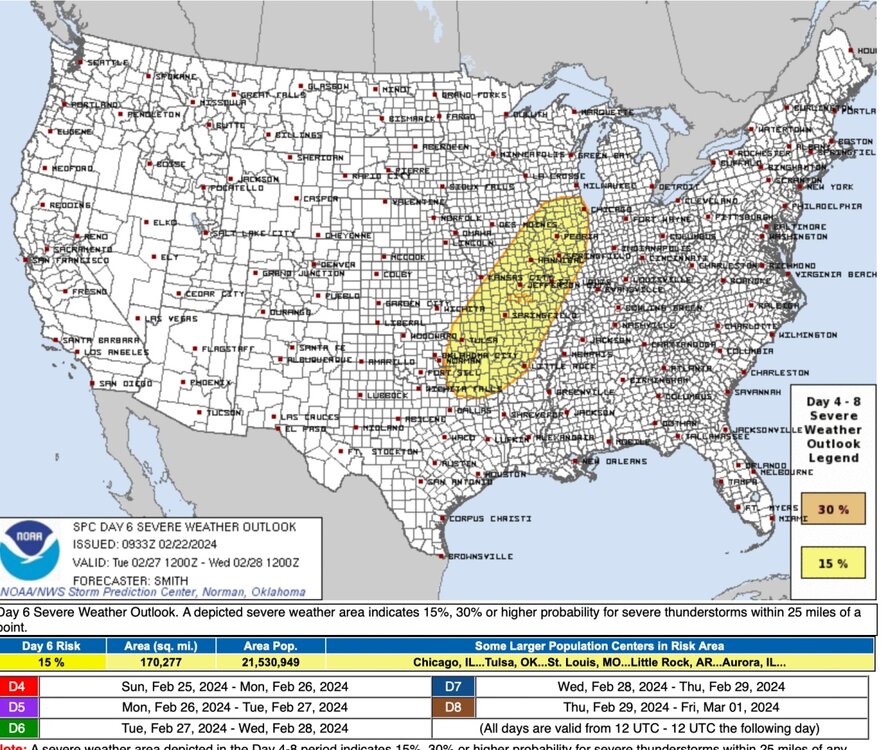
Thought I would get a thread started. Models looking relatively consistent today for an event early next week in Great Lakes region. Day 6 Day 7
-
Thought I would go ahead and get a thread started for what is looking to be a more consistent signal for an subform wide severe weather event this coming weekend. Day 4-5 discussion: A rather potent mid/upper shortwave trough for this time of year will develop eastward from the Mid/Upper MS Valley to the Northeast/Mid-Atlantic vicinity Sunday and Monday. At the surface, a deepening low will move across IA and WI/MI on Sunday, before lifting east/northeast across Ontario and Quebec on Monday. A trailing cold front will sweep across the Midwest and likely be approaching the I-95 corridor by Tuesday morning. Enhanced midlevel southwesterly flow associated with upper trough atop a very moist/unstable boundary layer will set the stage for a multi-day severe weather episode ahead of the eastward-advancing cold front. All severe hazards appear possible on Sunday from portions of eastern IA through southern WI/MI into much of IL/IN, northern KY, and western OH, as a linear convective system moves east across the region. Tornado potential likely will be focused closer to the surface low track, and along a warm front extending from the low east/southeast across parts of southern WI/MI into northern IL/IN. The system will continue east on Monday, impacting portions of the upper OH Valley/Lower Great Lakes/central Appalachians vicinity. The surface low will be shifting further northeast into Canada. Nevertheless, large-scale ascent associated with the upper trough, and moderate vertical shear atop very moist and unstable boundary layer will continue to support severe convection ahead of the eastward advancing cold front. Damaging winds will likely be the greatest concern on Monday.