crossbowftw3
-
Posts
1,324 -
Joined
-
Last visited
Content Type
Profiles
Blogs
Forums
American Weather
Media Demo
Store
Gallery
Everything posted by crossbowftw3
-
Lines on the left give the big hint. This sounding is excessively containinated
-
if this goes signifcant damaging wind event with several embedded tornadoes do you think it could be an even more volatile setup for that than 1/10-1/11?
-
This is no 4/27 but in every way it will be devastating to someone by the time the sun rises Monday morning.
-
Not personally sure myself. From my research of that event they only did 60% sig because they were certain a major outbreak would happen. A big outbreak did happen, but fell quite short of verifying. They did want to do day 2 high for 4/27 but questions about the morning wave prevented that. As we know now, that morning wave (really both) didn't. 4/27 probably would have verified 60% with room to spare in all honesty.
-
4/7/06 and 4/14/12
-
My own digging through model evidence makes me think something closer to 4/24/10 or Veteran's Day 2002. which wouldn't be 4/27 bad but still plenty bad on its own.
-
March 26-28 Severe Threat
crossbowftw3 replied to Tim from Springfield (IL)'s topic in Lakes/Ohio Valley
It's certainly very puzzling. I'm also agreeing based on early guesswork that we're seeing EF3 damage but how did this car get so terribly mangled? That'd be a sign of EF4 winds. -
March 26-28 Severe Threat
crossbowftw3 replied to Tim from Springfield (IL)'s topic in Lakes/Ohio Valley
This car though...
-
March 26-28 Severe Threat
crossbowftw3 replied to Tim from Springfield (IL)'s topic in Lakes/Ohio Valley
This threat is still very much in play. That complex is weakening and clearing is happening behind it. -
March 26-28 Severe Threat
crossbowftw3 replied to Tim from Springfield (IL)'s topic in Lakes/Ohio Valley
If they go high risk if not by 0600 then almost certainly by 1630, multiple precluding factors still at hand -
March 26-28 Severe Threat
crossbowftw3 replied to Tim from Springfield (IL)'s topic in Lakes/Ohio Valley
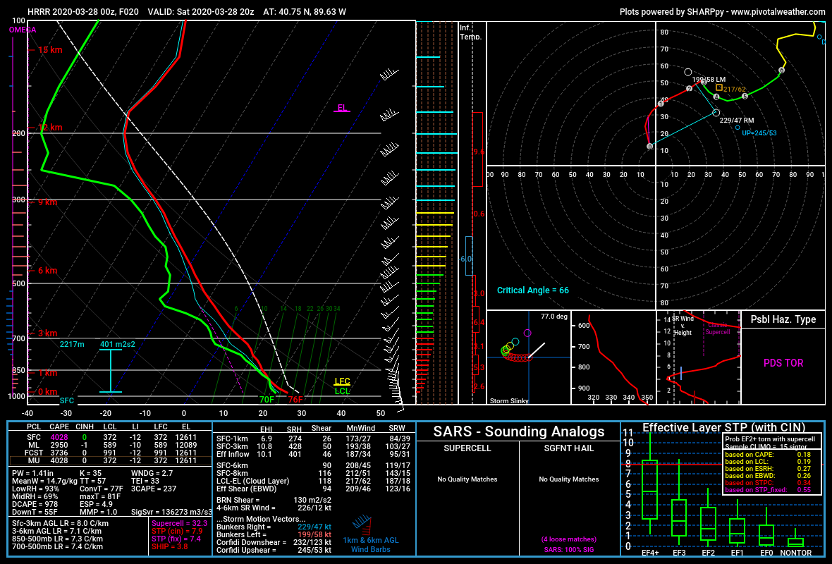
Pure eye candy sounding
-
March 26-28 Severe Threat
crossbowftw3 replied to Tim from Springfield (IL)'s topic in Lakes/Ohio Valley
Likely tons of discussions happening now at SPC hence why it's late. -
March 26-28 Severe Threat
crossbowftw3 replied to Tim from Springfield (IL)'s topic in Lakes/Ohio Valley
I would guess the Warm Front stalls within a 10-20 mile radius (+-) of Chicago metro. Even if the front gets hung up everything south of that is primed and ready. -
March 26-28 Severe Threat
crossbowftw3 replied to Tim from Springfield (IL)'s topic in Lakes/Ohio Valley
That they are. This one seems a bit less obvious than 5/20 at first but seems more probable to verify. Do they go high? It still boils down to what kind of boundaries morning convection leaves/how fast atmosphere recovers. -
March 26-28 Severe Threat
crossbowftw3 replied to Tim from Springfield (IL)'s topic in Lakes/Ohio Valley
HRRR STP values give me flashbacks -
March 26-28 Severe Threat
crossbowftw3 replied to Tim from Springfield (IL)'s topic in Lakes/Ohio Valley
The HRRR greatly oversold 5/20 so YMMV -
March 26-28 Severe Threat
crossbowftw3 replied to Tim from Springfield (IL)'s topic in Lakes/Ohio Valley
Wouldn't shock me if SPC goes high and/or expands that MDT area. All going to be dependent on morning convection. -
March 26-28 Severe Threat
crossbowftw3 replied to Tim from Springfield (IL)'s topic in Lakes/Ohio Valley
Some pretty impressive parameters setting up tomorrow. Regional outbreak with multiple strong tornadoes seems like a solid bet. -
Upstate/Eastern New York
crossbowftw3 replied to BuffaloWeather's topic in Upstate New York/Pennsylvania
Sleet/rain mix -
Upstate/Eastern New York
crossbowftw3 replied to BuffaloWeather's topic in Upstate New York/Pennsylvania
I'm about 800' in the southern Catskills. Round 1 for us is wrapping up, and at my elevation I'm expecting to warm up to rain/mixing by afternoon. Good luck up there. -
Looks like I got sucked into one last screw job by every model. Hoping for 2" now at best.
-
I get that, was simply pointing out how models seem to be distancing themsleves away from that idea. Like you I'm 20-30 miles north of 84 (at ~800) and am also only expecting 2-3" before likely mixing (or even a full changeover, which looks likelier) cuts down totals. MSV north looks good. Largely elevation dependent, but yeah, same points as provided before. They have their reasons and I respect them.
-
BGM WFO issued out warnings anyway when the all models are quickly shifting highest amounts away.
-
I don't think this was necessary needed because all models are shirking away from heavier snows. Still largely elevation dependent. 660 WWUS41 KBGM 221744 WSWBGM URGENT - WINTER WEATHER MESSAGE National Weather Service Binghamton NY 144 PM EDT Sun Mar 22 2020 NYZ057-062-231745- /O.UPG.KBGM.WS.A.0005.200323T0700Z-200324T0400Z/ /O.NEW.KBGM.WS.W.0004.200323T0900Z-200324T0400Z/ Delaware-Sullivan- Including the cities of Delhi, Walton, and Monticello 144 PM EDT Sun Mar 22 2020 ...WINTER STORM WARNING IN EFFECT FROM 5 AM MONDAY TO MIDNIGHT EDT MONDAY NIGHT... * WHAT...Heavy snow expected. Total snow accumulations of 5 to 9 inches across elevations higher than 1400 feet. Total snow accumulations of 2 to 5 inches in the valleys. * WHERE...Delaware and Sullivan counties. * WHEN...From 5 AM Monday to midnight EDT Monday night. * IMPACTS...Plan on slippery road conditions. The hazardous conditions could impact travel. Also, weight of heavy wet snow could produce some power outages. PRECAUTIONARY/PREPAREDNESS ACTIONS... If you must travel, keep an extra flashlight, food, and water in your vehicle in case of an emergency. The latest road conditions for the state you are calling from can be obtained by calling 5 1 1.
-
It's going to be 100%. Lower elevations probably 3-5 *if* it can stick well given late March sun/mixing; elevations >1500 feet will do best with probable 5-8.