

crossbowftw3
-
Posts
1,324 -
Joined
-
Last visited
Content Type
Profiles
Blogs
Forums
American Weather
Media Demo
Store
Gallery
Everything posted by crossbowftw3
-
Temperature spiked back up to 75 but dew point"only" at 65 now
-
At my location it's tumbled 12 degrees in the past hour so I doubt we have much if any instability left for this second wave. Granted I live very close to the eastern border between NY and PA.
-
It likely will run out of both time and instability the further east it progresses and the further in time we go.
-
Friday, May 15, 2020 Severe Weather Potential
crossbowftw3 replied to weatherwiz's topic in New England
I'm still south of there. One county south. -
Friday, May 15, 2020 Severe Weather Potential
crossbowftw3 replied to weatherwiz's topic in New England
80/58 at my location in SE NY near the southernmost edge of the line. That portion looks weak thus far. -
Friday, May 15, 2020 Severe Weather Potential
crossbowftw3 replied to weatherwiz's topic in New England
Assuming a severe watch will follow for the counties south of there, if the line can hold for much after sunset that is. -
Friday, May 15, 2020 Severe Weather Potential
crossbowftw3 replied to weatherwiz's topic in New England
Clouds quickly moving back in. 77/dew of 60 which has been in place since this morning. Probably not moving much further up. -
Friday, May 15, 2020 Severe Weather Potential
crossbowftw3 replied to weatherwiz's topic in New England
I'm assuming this as well. 65/60 where I'm at (Sullivan NY) but the line stoll looks on track to weaken by the time it makes it here after dark. Not seeing much suggesting discrete potential either. -
Friday, May 15, 2020 Severe Weather Potential
crossbowftw3 replied to weatherwiz's topic in New England
Wouldn't be shocked if it keeps trending NW. -
Friday, May 15, 2020 Severe Weather Potential
crossbowftw3 replied to weatherwiz's topic in New England
HRRR often likes to go bonkers with no inherent triggers for storms. See last year 5/20 -
Friday, May 15, 2020 Severe Weather Potential
crossbowftw3 replied to weatherwiz's topic in New England
No. Scattered wind damage at best; low 60s dews and trash LRs. -
Friday, May 15, 2020 Severe Weather Potential
crossbowftw3 replied to weatherwiz's topic in New England
A little questionable to see this enhanced. Tomorrow looks active but the day 2 upgrade seems to have jumped the gun a bit..it'll be active for sure at least -
Friday, May 15, 2020 Severe Weather Potential
crossbowftw3 replied to weatherwiz's topic in New England
Looks like a typical NEastern severe setup with our typical caveats. That said, can count on some scattered wind damage. -
Upstate/Eastern New York
crossbowftw3 replied to BuffaloWeather's topic in Upstate New York/Pennsylvania
Severe warning for Yates for hail. Storm looks elevated so wind probably isn't a problem there but count on 1" hail possibly. -
Upstate/Eastern New York
crossbowftw3 replied to BuffaloWeather's topic in Upstate New York/Pennsylvania
Changeover has finally arrived for me -
Upstate/Eastern New York
crossbowftw3 replied to BuffaloWeather's topic in Upstate New York/Pennsylvania
Still stuck at 40/38 but the changeover is encroaching on me quickly. Still praying for 1" before the precip shuts off by around Midnight. -
BGM is actually seeing snow? Meanwhile like 90 minutes south of there I'm 43/40 and just raining
-
Upstate/Eastern New York
crossbowftw3 replied to BuffaloWeather's topic in Upstate New York/Pennsylvania
Looks like my switch could commence later next week. 10 day forecast slowly surges us up until we hit near-70 by next Saturday and only goes up from there. -
Upstate/Eastern New York
crossbowftw3 replied to BuffaloWeather's topic in Upstate New York/Pennsylvania
Hoping for the best with the squalls. Regardless by Memorial Day we'll all be installing our Air Conditioners and this'll be but a passing memory in the wind as we roast in 80 degree/65+ dew point heat -
Upstate/Eastern New York
crossbowftw3 replied to BuffaloWeather's topic in Upstate New York/Pennsylvania
Pretty much praying for an inch now but tomorrow's squalls look more juicy anyway. Gonna feel like a mid winter day even in between the possible squalls. Hoping whoever has to go on the roads are ready for them. -
Upstate/Eastern New York
crossbowftw3 replied to BuffaloWeather's topic in Upstate New York/Pennsylvania
Still count on a burst of snow but the writing on the wall was pretty evident -
Upstate/Eastern New York
crossbowftw3 replied to BuffaloWeather's topic in Upstate New York/Pennsylvania
18z Euro is (probably) the final nail in the coffin.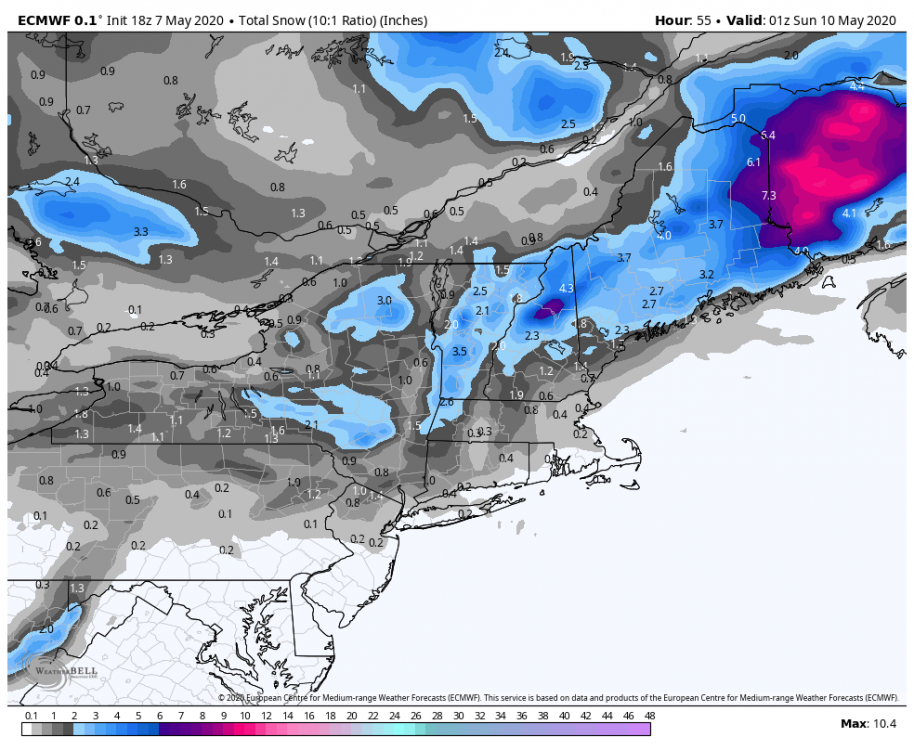
-
Upstate/Eastern New York
crossbowftw3 replied to BuffaloWeather's topic in Upstate New York/Pennsylvania
Overall though the models are slowly moving away from a more widespread heavier snow which makes sense. still not counting on much more than a 1-3/3-5 deal, yet that doesn't matter as it'll for certain be the latest I've seen snow on record. -
Two days before Garfield but three days after Twosday.
-
The last minute shift SE. Unfortunately quite typical no matter when a storm is on tap Regardless I don't think this has potential for more than 2-4, at least where I'm at this far west. Timing of precip would've needed to be like four or five hours slower to actually have snow. Fast mover too. If there's to be 2-4 it's likelier east of me with far more favorable timing. WPC guidance in lime with my thoughts.


