

crossbowftw3
-
Posts
1,399 -
Joined
-
Last visited
Content Type
Profiles
Blogs
Forums
American Weather
Media Demo
Store
Gallery
Everything posted by crossbowftw3
-
Clouds moved back over, sustained wind of 16 gusts to around 30 or so. Got the feel of a big storm without anything actually happening
-
December 2020 General Discussions & Observations Thread
crossbowftw3 replied to bluewave's topic in New York City Metro
In conjecture with this, some crazy impressive analogs have been tossed around, which include both super outbreak years, and 2008 (Super Tuesday, early January Outbreak being among most notable). Not to say events of those magnitudes occur but overall it paints a very ugly picture -
December 2020 General Discussions & Observations Thread
crossbowftw3 replied to bluewave's topic in New York City Metro
As a side note, moderate nina = big trouble for the south when spring comes around. -
Upstate/Eastern New York
crossbowftw3 replied to BuffaloWeather's topic in Upstate New York/Pennsylvania
Seeing lots of changeovers happening for our New England friends....they'll be getting whalloped later on. -
Widespread outage event for New England while most of us here will probably see more isolated-scattered with our big issue for the rest of the day being wind. It should be said most in the New England forum are already changing over...hours ahead of schedule
- 373 replies
-
- 1
-

-
- heavy rain
- wind event
- (and 2 more)
-
December 5-6, 2020 Storm Observations and Nowcast
crossbowftw3 replied to Baroclinic Zone's topic in New England
Hearing snow in the air east of of me across Orange/Putnam/Dutchess....it's coming, most of you should gradually change over before the big boy band begins -
The ratios will be so low though that the threat for rather widespread outages will only go up through the day...still guessing 7-8:1 for a large amount of the time. If only Cantore was able to station himself in Worcester. That's a sure recipe for some thundersnow to happen
- 373 replies
-
- 1
-
-
- heavy rain
- wind event
- (and 2 more)
-
Gotta wonder if that's the beginning of the band that's going to produce the 2-3" hourly rates once it arrives into CT/MA
- 373 replies
-
- 1
-
-
- heavy rain
- wind event
- (and 2 more)
-
Some eminent signs of the change beginning in W MA/CT as well
- 373 replies
-
- 1
-

-
- heavy rain
- wind event
- (and 2 more)
-
It's dry up here but feels rather moist. New England is going to get absolutely whacked once they change over.
-
Dec 5/6th major coastal/ west Atlantic cyclogenesis ...?
crossbowftw3 replied to Typhoon Tip's topic in New England
High and dry in the Catskills (as I suspected) but the atmosphere feels like it's got a lot of moisture to it. Once this winds up its going to absolutely pound in New England. -
Dec 5/6th major coastal/ west Atlantic cyclogenesis ...?
crossbowftw3 replied to Typhoon Tip's topic in New England
WPC blends every model but mostly takes from NBM if I'm not mistaken -
Dec 5/6th major coastal/ west Atlantic cyclogenesis ...?
crossbowftw3 replied to Typhoon Tip's topic in New England
That's legit nutty. While I'm sucking cirrus on a 15 MPH wind I'm gonna be in my house looking at nearly every cam possible -
Dec 5/6th major coastal/ west Atlantic cyclogenesis ...?
crossbowftw3 replied to Typhoon Tip's topic in New England
snow map? For my curiosity's sake -
Upstate/Eastern New York
crossbowftw3 replied to BuffaloWeather's topic in Upstate New York/Pennsylvania
Never forget that one, but same will not happen here, sadly. The Pi Day storm was just perfect...what I would give to have another one of those right now, ha -
Good catch. I expect BOX and GYX will have to issue out Warnings within the next several hours. People might find themselves a little caught out knowing that today isn't exactly cold and that the precipitation is beginning as rain.
-
Doesn't look like much more than noise, however, since this run of the GFS looks most like 0z last night. All models probably will soon converge and are doing so already. Next week looks much more tantalizing at this rate.
-
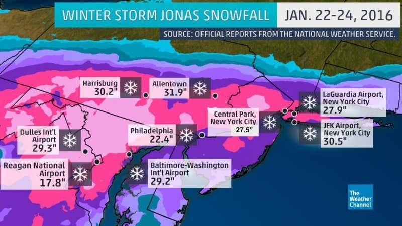
The mention of Jonas in the coastal thread reminded me to pull this up. Probably the most pain I've ever felt from a snowstorm. You guys definitely reaped the benefits though. A gradient of 40 miles shut me out of over 8" and two hours shut me out from almost 30"
-
Upstate/Eastern New York
crossbowftw3 replied to BuffaloWeather's topic in Upstate New York/Pennsylvania
Probably just trying to join the fray seeing how 6z didn't seem to have anything -
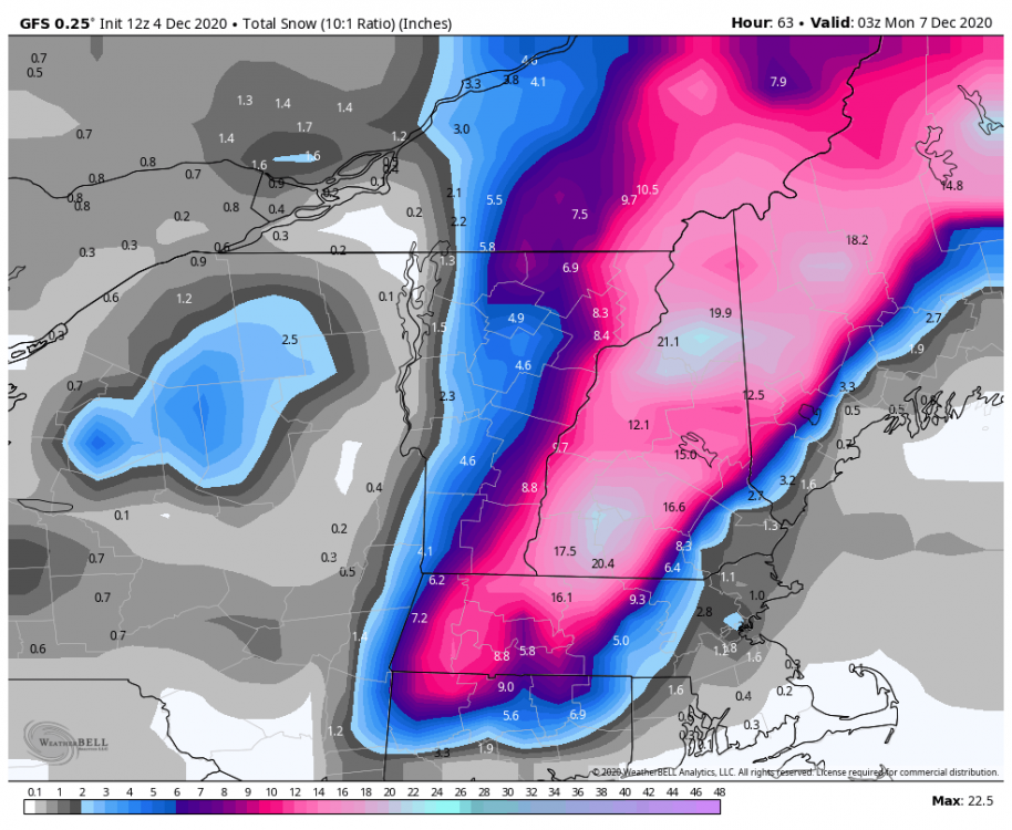
That was a massive whiff. Jonas followed the year after for us. We got nothing from either storm, and Jonas hurt even more. Latest GFS snows. It's all but certain now where the biggest whack will be
-
Dec 5/6th major coastal/ west Atlantic cyclogenesis ...?
crossbowftw3 replied to Typhoon Tip's topic in New England
Hoping for flakes of any kind, as all of us in the NYC forum are and N&W from there, but it's all but certain now where the best snow is setting up tomorrow -
Upstate/Eastern New York
crossbowftw3 replied to BuffaloWeather's topic in Upstate New York/Pennsylvania
Running out of time for those. This model cycle, if not 18/0z, probably will converge on the common solution. New England going to certainly get whacked. Latest GFS. N CT and northeast will get slammed.
-
Hoping the QPF nudges just enough to get me over a quarter inch of rain/some frozen
-
Dec 5/6th major coastal/ west Atlantic cyclogenesis ...?
crossbowftw3 replied to Typhoon Tip's topic in New England
:sad: -
Upstate/Eastern New York
crossbowftw3 replied to BuffaloWeather's topic in Upstate New York/Pennsylvania
GFS ticked back slightly west but it does nobody here any good, not even us in BGM CWA. @sferic @Ericjcrash maybe some flakes for you two tomorrow.