

crossbowftw3
-
Posts
1,324 -
Joined
-
Last visited
Content Type
Profiles
Blogs
Forums
American Weather
Media Demo
Store
Gallery
Everything posted by crossbowftw3
-
If another tick or two happens southeast we will likely end up out of warning amounts. Models finally picking up confluence...as I had always said this had a chance to evolve to a 95 crusher and it's already getting there: will us north of 84 slip out of warning level totals remains to be seen
-
Upstate/Eastern New York
crossbowftw3 replied to BuffaloWeather's topic in Upstate New York/Pennsylvania
That map was probably done with older data. Come later on it'll be different. -
Upstate/Eastern New York
crossbowftw3 replied to BuffaloWeather's topic in Upstate New York/Pennsylvania
The confluence is strong with this one, we could still get smoked in the negative direction but this is still fine: county-wide 6-12 is still good enough for me. We must watch tonight's runs either way. -
Upstate/Eastern New York
crossbowftw3 replied to BuffaloWeather's topic in Upstate New York/Pennsylvania
Fading away. Consensus growing and it's not working out for me nor anyone else here. Can't help but thinking one or two more ticks SE. The fringe, man..thumb.png.dc96f6798ba37fbaec41b2be5358f3e3.png)
-
Upstate/Eastern New York
crossbowftw3 replied to BuffaloWeather's topic in Upstate New York/Pennsylvania
Not a great sign. Sitting at the fringe in setups like these doesn't work out at least half of the time. Going to sweat this one out without a doubt over the next 48 hours. -
The fringe has bitten us in the rear end before and might just do it again here. Thinking a failure mode is still 3-6 or marginal warning snows at this point.
-
To this end the next two euro runs will be highly telling. 84 south is all but good to go here. Those of us north will sweat this out.
-
We are definitely teetering here. Right now I'm still thinking around 8-12 but bust options very much still in play and potentially increasing. When this kind of confluence exists I start to feel nervous.
-
I'm 30 miles north of 84 in Sullivan. This will get precarious. BGM has watches up for Southern Wayne which is close to me for potential totals over 6". Interesting to see what today brings.
-
Upstate/Eastern New York
crossbowftw3 replied to BuffaloWeather's topic in Upstate New York/Pennsylvania
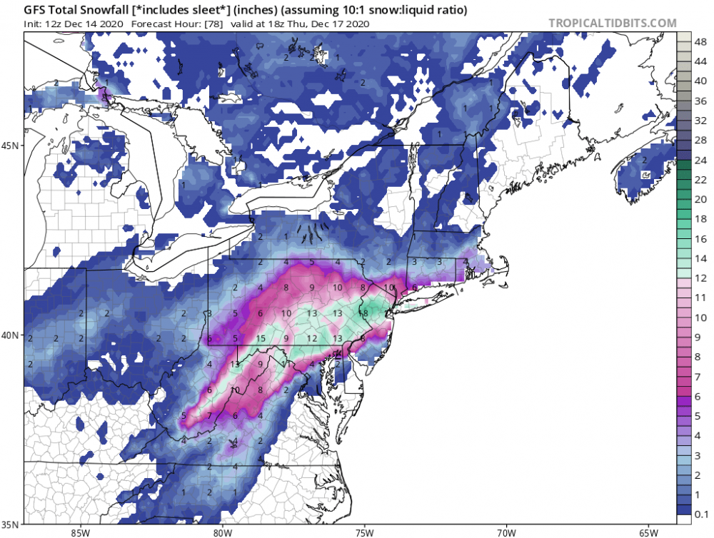
RGEM had a pretty good death band pivoting from SEPA onto LI--somewhere near there could be jackpot. Also kind of doubt 2'+ as I always have with this but can just as easily assume somewhere in there gets up to 18" max. -
Upstate/Eastern New York
crossbowftw3 replied to BuffaloWeather's topic in Upstate New York/Pennsylvania
This euro run will be telling. The heaviest snow axis might be beginning to actually get nailed down. Somewhere between SEPA and NYC will get close to 2 feet I think. Question remains: where is the northern extent of snow? Riding very much on that at the moment. Most every run has taken me from over 1' to 6-10 this morning. -
1.2 to 2.7 here. Trend still needs a bit more to go to be my friend.
- 3,762 replies
-
- 1
-

-
- heavy snow
- heavy rain
- (and 3 more)
-
Upstate/Eastern New York
crossbowftw3 replied to BuffaloWeather's topic in Upstate New York/Pennsylvania
Someone close to NYC will get the jack if a blend of RGEM and GFS plays out. That band on RGEM will crush whoever ends up under it. -
Somewhere between Philly and NYC will get the jack if RGEM is closest to reality. That band will crush whoever ends up under it.
-
Active mid December with multiple event potential
crossbowftw3 replied to Typhoon Tip's topic in New England
Easily a foot for them. -
Still can't 100% count out GFS I think. Wouldn't be shocked if something like the GFS happened but brought north a tad more than it already is. Areas in and around NYC should still be very good for totals of at least 6-10".
- 3,762 replies
-
- 1
-

-
- heavy snow
- heavy rain
- (and 3 more)
-
Upstate/Eastern New York
crossbowftw3 replied to BuffaloWeather's topic in Upstate New York/Pennsylvania
Can't ignore GFS still until it for sure tanks to other guidance. I wouldn't be shocked if something like the GFS happened but brought further north a tad. RGEM being in tandem with it is somewhat telling. We will see what euro does in a few hours. Right now if I were to blend everything I'd still probably get 8-12 while somewhere near NYC easily gets over a foot -
Makes the most sense as of this moment. Might even drop to 15 degrees at my house if point and click is to be believed.
- 3,762 replies
-
- 2
-
-
- heavy snow
- heavy rain
- (and 3 more)
-
Upstate/Eastern New York
crossbowftw3 replied to BuffaloWeather's topic in Upstate New York/Pennsylvania
That euro main run made me both smile and grimace both at once. Still fine but this could still get ugly in a hurry. If this keeps trending south I'll still take 5-8 but.... -
Upstate/Eastern New York
crossbowftw3 replied to BuffaloWeather's topic in Upstate New York/Pennsylvania
If you guys beat Arizona the cardinals would be 5-7 just like the Giants. We need to beat them, lol -
Upstate/Eastern New York
crossbowftw3 replied to BuffaloWeather's topic in Upstate New York/Pennsylvania
That GFS run wasn't very comforting. 0z will tell all. Essentially back to where we were this time yesterday. -
I'm going to guess....sometime between 2014 and 2017?
-
My fear as well, still being maintained into this morning. 0z runs tonight will be key for us. Even if a relative whiff happens I'd think we'd still be good for 3-6".
- 3,762 replies
-
- 1
-
-
- heavy snow
- heavy rain
- (and 3 more)
-
I still fear this happening. Still going par the course for my BY but you raise a good point here.
-
Upstate/Eastern New York
crossbowftw3 replied to BuffaloWeather's topic in Upstate New York/Pennsylvania
Good point.
.png.0f8f63eabd7fbd643249f889c49a276f.png)
