

crossbowftw3
-
Posts
1,324 -
Joined
-
Last visited
Content Type
Profiles
Blogs
Forums
American Weather
Media Demo
Store
Gallery
Everything posted by crossbowftw3
-
January 2021 General Discussions & Observations Thread
crossbowftw3 replied to Stormlover74's topic in New York City Metro
Gotta wade through the mud to find the goldmine. Tomorrow’s event will come and go, and Sunday-Monday hinges on a marginal airmass, but I can’t wait to see what happens mid-month. Up here we made it to roughly 1/3 of what we had last year from the 16th/17th (36 inches which was roughly 25-30 below average) and here’s to hoping we can cover our totals from last year (if at all possible) by then. -
Advisories will probably get issued later on today, and maybe some WSWs for CTP? (Only really because their threshold for WSWs is .25 of ice). Either way Sunday-Monday is of more interest at this point
-
December 2020 General Discussions & Observations Thread
crossbowftw3 replied to bluewave's topic in New York City Metro
It stayed rain all night here -
The trends on the NAM are a bit surprising but again we can be thankful this doesn’t have much staying power and/or much precipitation to go with it...otherwise problems would certainly begin to arise. I’ll definitely be on the lookout for HREFs tomorrow but figure I’ll stay right where I am with .1-.3 with maybe a high end of .5 in typical elevations where the cold takes longest to clear out. Pretty typical messy little system and to me it never changed from being that.
-
Dec (Edit: Jan1/..2 ) multi-faceted ptype mess potential...
crossbowftw3 replied to Typhoon Tip's topic in New England
Is it time to order up a MLK blizzard? -
Looks like my guess of .1-.3 of ice for most who do see it still makes sense after some of today’s runs. It’ll be a long gone memory by the end of the day Saturday anyway.
-
Dec (Edit: Jan1/..2 ) multi-faceted ptype mess potential...
crossbowftw3 replied to Typhoon Tip's topic in New England
Didn’t areas near Ottawa have to deal with continually falling ZR for up to five days? Regardless this isn’t that by any means, still think .1-.3 is good enough of a guess for areas that do see the ice -
Upstate/Eastern New York
crossbowftw3 replied to BuffaloWeather's topic in Upstate New York/Pennsylvania
That's right, how could I forget? Ha Either way still pretty much nothing more than a nuisance, especially the day after NYE when people are trying to move about and get back home from festivities -
Upstate/Eastern New York
crossbowftw3 replied to BuffaloWeather's topic in Upstate New York/Pennsylvania
Thinking any icing is probably limited to .1-.25 for most but given your location you could see slightly more ice and maybe more frozen overall -
As an aside, here’s one facet of this storm I don’t think happens every day: up to 2’ in South Texas of all places. URGENT - WINTER WEATHER MESSAGE National Weather Service Midland/Odessa TX 436 AM CST Wed Dec 30 2020 ...SIGNIFICANT WINTER STORM TAKING AIM ON THE REGION...RESULTING IN ACCUMULATING SNOW THIS AFTERNOON THROUGH THURSDAY FOR MOST OF THE REGION...PARTICULARLY LOCATIONS ALONG AND SOUTH OF I-20... TXZ046>048-050>053-060>063-067>070-075-082-274>282-302300- /O.UPG.KMAF.WS.A.0005.201230T1800Z-210101T0600Z/ /O.NEW.KMAF.WS.W.0004.201230T1800Z-210101T0600Z/ Dawson-Borden-Scurry-Andrews-Martin-Howard-Mitchell-Winkler-Ector- Midland-Glasscock-Ward-Crane-Upton-Reagan-Pecos-Terrell- Reeves County Plains-Chinati Mountains-Marfa Plateau- Davis Mountains-Davis Mountains Foothills-Central Brewster County- Chisos Basin-Presidio Valley-Lower Brewster County- Including the cities of Lamesa, Andrews, Stanton, Big Spring, Colorado City, Kermit, Odessa, Midland, Monahans, Crane, McCamey, Rankin, Big Lake, Fort Stockton, Dryden, Sanderson, Pecos, Marfa, Fort Davis, Alpine, Panther Junction, Chisos Basin, Presidio, and Castolon 436 AM CST Wed Dec 30 2020 ...WINTER STORM WARNING IN EFFECT FROM NOON TODAY TO MIDNIGHT CST THURSDAY NIGHT... * WHAT...Heavy snow expected. Total snow accumulations of 4 to 7 inches expected across portions of the Permian Basin, Trans Pecos, Culberson county, Big Bend Area, and Presidio Valley. Accumulations 7 to 12 inches expected across the southeastern Permian Basin and along I-10 to the I-10/I-20 Split, and Marfa Plateau. Accumulations 12 to 17 inches expected from the Davis Mountains east across the Stockton Plateau. Locally higher amounts will be possible. * WHERE...Portions of southwest and western Texas. * WHEN...From noon today to midnight CST Thursday night. * IMPACTS...Travel will be very difficult to impossible. Some roads along and south of I-10 will become impassable, possibly including I-10 from the Split to Fort Stockton. The hazardous conditions will impact the morning or evening commute.
-
If there is any ice it should be manageable, think advisory amounts of maybe .1-.3...we will flip to rain and warm into the 40s Saturday.
-
Should be interesting. In any case once we warm and flip completely to rain it should only keep warming further from there, my high Saturday is now mid-40s. An issue to probably still sort out is when the flip happens. At my lower elevation in Sullivan, my house could probably stay all rain as it did last 12/29, while areas like MSV become a mess.
-
That was what I pretty much figured in my post above, looks plenty messy but fairly typical. Right now my P&C has me as rain-sleet mix for most of Friday.
-
So upon doing the math and knowing QPF isn't always 1:1 in these situations I'd assume .1-.3 with higher elevations going up to .5" of ice @wdrag what would you guess in this case?
-
Dec (Edit: Jan1/..2 ) multi-faceted ptype mess potential...
crossbowftw3 replied to Typhoon Tip's topic in New England
84 and north if I had to guess at this time -
Dec (Edit: Jan1/..2 ) multi-faceted ptype mess potential...
crossbowftw3 replied to Typhoon Tip's topic in New England
I would think with your typical paring down with ZR QPF not being 1:1 probably a widespread .1-.3" with higher elevations going up to .5". -
any clue on how much icing might be possible in that window?
-
@wdrag I did get a chance to go down to take a look at the Delaware...did not get photos but it seemed normal. However, a family member (my mother, for what it’s worth) who had to go to work reported that the creek near where her work is was ready to spill into the road. Other than that things seem decently fine up here.
- 242 replies
-
- 1
-

-
- damaging wind
- flooding rains
- (and 1 more)
-
Winds have dropped rapidly since the front came through. Worst I figure is pretty much over here windwise. Rain is still falling, which only exacerbates that problem. Unfortunately it'll be hours before we all get the reprieve of the front
-
Christmas Eve/Day Annual Scrooger Event
crossbowftw3 replied to Baroclinic Zone's topic in New England
Matter of fact...copy/pasted from metro forum. KDOX issue: Dec 24 2020 22:42:02 Dover AFB Radar (KDOX) is currently experiencing some data quality errors due to an ongoing equipment issue. While velocity (V) data appears representative, reflectivity data (Z) is running high/"hot". Technicians have been notified and will continue to troubleshoot the radar over the coming days. Please use this data with caution for the time being. Thank you and we apologize for the inconvenience -
Christmas Eve/Day Annual Scrooger Event
crossbowftw3 replied to Baroclinic Zone's topic in New England
Perhaps so....something with the algorithm? I have seen this happen before, here’s an example from May. The areas shown weren’t reporting any form of returns.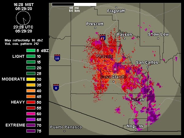
-
Yeah definitely no way we have 75 DBz+ echoes happening at the moment. That’d have to be indicative of some seriously incredible rain rates which again, don’t match ground truths. I have seen this occur before when looking over some radar imagery in the Desert Southwest—indicative of a bad radar algorithm. Here was an example from this past summer. At this point in time the areas shown here were high and dry without any precipitation occurring.
- 242 replies
-
- 1
-
-
- damaging wind
- flooding rains
- (and 1 more)
-
Per weatherwiz in NE forum it’s more likely something funky is happening with that radar. Observations/ground truths I’ve seen don’t match appearances
- 242 replies
-
- 3
-

-

-
- damaging wind
- flooding rains
- (and 1 more)
-
Christmas Eve/Day Annual Scrooger Event
crossbowftw3 replied to Baroclinic Zone's topic in New England
Wouldn’t that be a case of bright banding or no? I would think not, for what it’s worth, but who knows -
The silver lining is that most of the next week after this looks generally quiet so most of the water (that doesn’t freeze anyway) would recede. Hoping they’ve got their preparations good to go.
- 227 replies
-
- 1
-
-
- heavy rain
- flooding potential
- (and 2 more)