crossbowftw3
-
Posts
1,401 -
Joined
-
Last visited
Content Type
Profiles
Blogs
Forums
American Weather
Media Demo
Store
Gallery
Everything posted by crossbowftw3
-
2-7-21 Sunday 8-12 hour nor'easter snowstorm roughly 5A-5P
crossbowftw3 replied to wdrag's topic in New York City Metro
I would anticipate BGM issuing advisories for Sullivan, Delaware and into Wayne/Pike PA possibly now -
2-7-21 Sunday 8-12 hour nor'easter snowstorm roughly 5A-5P
crossbowftw3 replied to wdrag's topic in New York City Metro
Looks like low-end advisory snows here. Don't mind it at all, but I want to see one more tick to get us to 3-6" -
2-7-21 Sunday 8-12 hour nor'easter snowstorm roughly 5A-5P
crossbowftw3 replied to wdrag's topic in New York City Metro
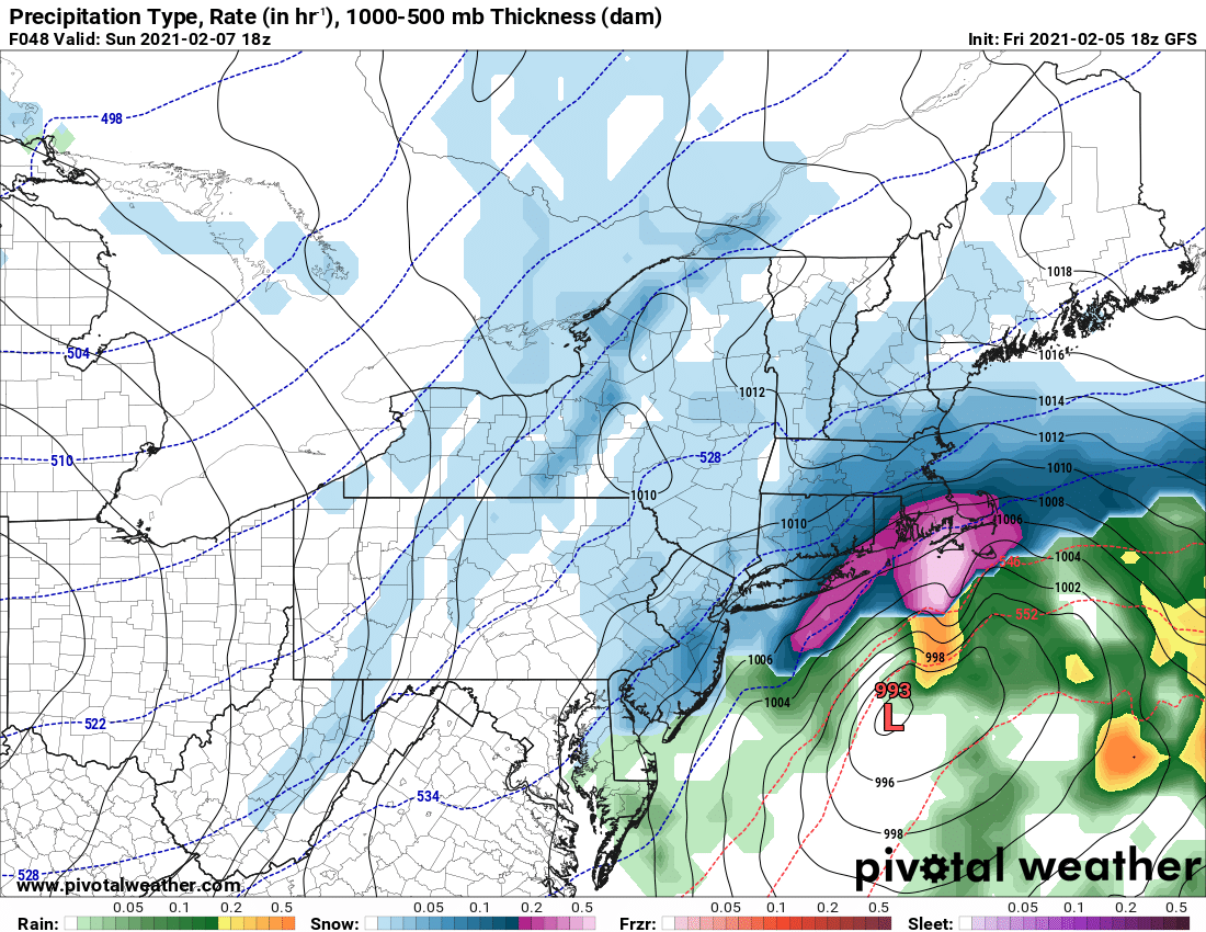
What is exactly going on here with the GFS....?
-
2-7-21 Sunday 8-12 hour nor'easter snowstorm roughly 5A-5P
crossbowftw3 replied to wdrag's topic in New York City Metro
Marginal warning at that, it would still be just as possible to issue a high end WWA for 4-7. Don't like the idea overall for anything over that this far inland -
2-7-21 Sunday 8-12 hour nor'easter snowstorm roughly 5A-5P
crossbowftw3 replied to wdrag's topic in New York City Metro
that's still close to upper bound WWA for inland areas -
2-7-21 Sunday 8-12 hour nor'easter snowstorm roughly 5A-5P
crossbowftw3 replied to wdrag's topic in New York City Metro
3-6 still seems good -
2-7-21 Sunday 8-12 hour nor'easter snowstorm roughly 5A-5P
crossbowftw3 replied to wdrag's topic in New York City Metro
I know not many here would care about NASCAR but the original President’s Day blizzard did something very similar and many call it the reason it exists as it does now -
2-7-21 Sunday 8-12 hour nor'easter snowstorm roughly 5A-5P
crossbowftw3 replied to wdrag's topic in New York City Metro
Probably take a blend of NAM and (insert guidance here) to get something that’ll probably end up close to reality; hence, 2-6 with pockets of 6-10 -
2-7-21 Sunday 8-12 hour nor'easter snowstorm roughly 5A-5P
crossbowftw3 replied to wdrag's topic in New York City Metro
Wide swath of 5-8 with 10” lollies scattered about for 95 -
2-7-21 Sunday 8-12 hour nor'easter snowstorm roughly 5A-5P
crossbowftw3 replied to wdrag's topic in New York City Metro
If the 12z suite moves towards this solution I would believe watches would be needed by the mid—afternoon cycle at earliest for OKX, BOS, and Mt. Holly -
2-7-21 Sunday 8-12 hour nor'easter snowstorm roughly 5A-5P
crossbowftw3 replied to wdrag's topic in New York City Metro
Let’s just say yes for sake of logic regarding Urban Heat islands -
2-7-21 Sunday 8-12 hour nor'easter snowstorm roughly 5A-5P
crossbowftw3 replied to wdrag's topic in New York City Metro
2-6 inland and 5-10 coasts iso 12” make sense? -
2-7-21 Sunday 8-12 hour nor'easter snowstorm roughly 5A-5P
crossbowftw3 replied to wdrag's topic in New York City Metro
Wow still looks good for 2-5 here but this is continuing to build into a coastal special -
That’s overkill perhaps a much more useful guide on how long this pattern continues to sustain? https://www.linkedin.com/feed/update/urn:li:share:6763089451045535744
-
2-7-21 Sunday 8-12 hour nor'easter snowstorm roughly 5A-5P
crossbowftw3 replied to wdrag's topic in New York City Metro
with temps getting at least a few degrees above freezing not much will survive the morning -
2-7-21 Sunday 8-12 hour nor'easter snowstorm roughly 5A-5P
crossbowftw3 replied to wdrag's topic in New York City Metro
there could be, but a very isolated exception rather than the norm -
subfreezing highs to the Southern Coastlines would not be a good thing at all lol
-
Upstate/Eastern New York
crossbowftw3 replied to BuffaloWeather's topic in Upstate New York/Pennsylvania
Ceiling is still only 6-10/12 at most, thing is probably done by the time the game begins lol Either way, most conducive pattern in years for cold/snow. Just from the three biggest storms thus far we've already beaten what we got last year by over 10" with a full month to go, I'd call this winter a success so far for MBY. -
Upstate/Eastern New York
crossbowftw3 replied to BuffaloWeather's topic in Upstate New York/Pennsylvania
Hanging in pretty good here in Sullivan to where I think 3-6 is probably plausible for Sunday. The coasts might actually get two legit 10+" storms in the same week for the first time in years -
2-7-21 Sunday 8-12 hour nor'easter snowstorm roughly 5A-5P
crossbowftw3 replied to wdrag's topic in New York City Metro
If I had to make an early guess I'd almost certainly bet 4-8/6-10 across the region with the 10 most common on the coasts and just inland. For @snywx @sferic and I 4-7" seems most plausible -
2-7-21 Sunday 8-12 hour nor'easter snowstorm roughly 5A-5P
crossbowftw3 replied to wdrag's topic in New York City Metro
Either way it’s actually a bit of a legit shock to see a pack-reinforcing storm to be coming so close behind such a “massive” blizzard as last weekend was, even if this looks more like a moderate event at best -
2-7-21 Sunday 8-12 hour nor'easter snowstorm roughly 5A-5P
crossbowftw3 replied to wdrag's topic in New York City Metro
If it does I would agree with the idea of 6-10 as a high end despite the fast movement—mainly focused on the coastal areas perhaps? Otherwise 3-6/4-8 event -
non-accumulating snow now 29/27. another inch or so fell in the last few hours so final total probably ends at around 23". Easily a top 3 or 4 storm I've ever personally witnessed.
-
Started with 3” snow depth from last Tuesday, measured out 25” in three different spots so approximate final total is around 22” and still potentially delivering around another inch or two today. This is truly one for the books.
-
10” here, had to revise from my earlier guesstimate of a foot upon further precise measuring. Biggest flakes of the day now, would guess it’s only now falling back to around 10:1 ratio snow. Missing the bigger band just to my south.