

crossbowftw3
-
Posts
1,399 -
Joined
-
Last visited
Content Type
Profiles
Blogs
Forums
American Weather
Media Demo
Store
Gallery
Everything posted by crossbowftw3
-
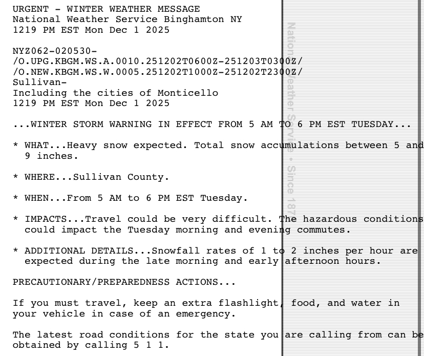
Tomorrow could be a legitimate 2-4” event here. That, coupled with the potential this weekend, could push me close to 30” for the season and it isn’t even January yet.
-
Finished up right at 8”, largely within the 8 hour period from 7:15 AM to 3:15 PM. With arctic shots incoming this pack will stay around a bit.
-
A public storm report from within the area of Narrowsburg has 8”, so a consistent rate of at least 1” an hour since about 7:15 am. Haven’t seen a blitz quite like this since 3/14/17 or Feb 2021–and those were 2-3 times larger totals wise.
-
Heading for 7” at this point
-
Went for a proper measure and 4” on the dot. About 1” an hour since it commenced at 7:15 this morning.
-
Looking at possibly 3” but that back end is chugging. Will be done by sunset most likely.
-
Snow just broke out within the last few minutes. We are underway.
-
That said:
-
I turn 28 in January and I do remember how horrid 2011-12 was after the big one in October. 2015 with the 70s Christmas week was shocking, and I missed on bigger snows for January 2016 blizzard by barely 40 miles. To some degree I do know.
-
On the western side of the county (Narrowsburg area) at slightly lower elevation so more 4-6” and possibly drizzle to end, if we even get that warm.
-
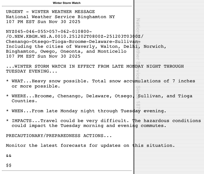
Looking pretty much set for folks like you and I. An 8-12 hour snow blitz and out by the end of tomorrow.
-
Surely more to come this winter..
-
It was track wise more than QPF output. 12-18 isn’t happening but 6-8 as depicted in p/c still makes sense
-
NAM running, so if it crashes to everything else some watches probably start going up by the end of the day, I would think edit: would appear it has
-
Initial point and click of 6-8”, looks reasonable at upper bound. If we can just figure out NAM being out to lunch a decent starter storm will be at hand.
-
Liking where I sit here with this one, granted it remains 96 hours out as of now. and with that, another winter in the trenches.
-
Has been off and on intense downpours since just before I left for work this morning. Going to be rather ugly to attempt to get home later.
-
81/75 at not even 9 am, game on for heat unfortunately
-
From what records I could find, no.
-
This is beginning to look like serious big league heat now. Maybe on one hand I can count days that ever got as hot as Monday/Tuesday are now forecasted to be.
-
Not fun!
-
This is gonna suck, isn’t it? I don’t think I’ve ever seen a temp/DP combo quite like 96/75

-
And as insult to injury from that week, the moment I (and the town) got power back that Friday night, the furniture store in town went up in flames and burned down It’s become something else since— what was a bank on that stretch of town road is now a brewery for instance
-
Seven years ago today, the derecho that blew through sheared the porch off the house at my old place. Still probably one of the scariest days of my life but the one that re-ignited my weather interests Back to today, 5.30" for the month and more rain incoming the next few days.
-
.5-1” snow here. A mildly nice surprise for this late in the going. It’s going to be washed away later anyway.


