crossbowftw3
-
Posts
1,324 -
Joined
-
Last visited
Content Type
Profiles
Blogs
Forums
American Weather
Media Demo
Store
Gallery
Everything posted by crossbowftw3
-
Meanwhile in Sullivan temperatures are doing the opposite, down to 67 from a high of 74.,
-
It's quite possible for some kind of snow to happen here on April Fool's and the following day. Widespread event as the models today have them? Probably not
-
1977 notable for the freak blizzard that hammered interior sections as well
-
As things look now we may see one last snap of cold end of next week. After that it's anyone's guess
-
end of next week may offer one last cold snap that lasts 2-3 days or so and dare i say it....it may come with some snow. Doubt anything widespread as today's runs of GFS are showing but the potential does exist
-
Upstate/Eastern New York
crossbowftw3 replied to BuffaloWeather's topic in Upstate New York/Pennsylvania
Advisories populating for us downstate folks Northern Oneida-Chemung-Tompkins-Southern Oneida-Cortland- Chenango-Tioga-Broome-Sullivan-Bradford-Susquehanna- Northern Wayne-Wyoming-Lackawanna-Luzerne-Pike-Southern Wayne- Including the cities of Boonville, Elmira, Ithaca, Rome, Utica, Cortland, Norwich, Owego, Waverly, Binghamton, Monticello, Sayre, Towanda, Hallstead, Montrose, Damascus, Equinunk, Tunkhannock, Scranton, Hazleton, Wilkes-Barre, Milford, and Honesdale 335 PM EDT Thu Mar 25 2021 ...WIND ADVISORY IN EFFECT FROM 11 AM TO 8 PM EDT FRIDAY... * WHAT...Southwest winds 15 to 25 mph with gusts of 40 to 50 mph expected. * WHERE...In Pennsylvania, Bradford, Susquehanna, Northern Wayne, Wyoming, Lackawanna, Luzerne, Pike and Southern Wayne counties. In New York, Northern Oneida, Chemung, Tompkins, Southern Oneida, Cortland, Chenango, Tioga, Broome and Sullivan counties. * WHEN...From 11 AM to 8 PM EDT Friday. * IMPACTS...Gusty winds could blow around unsecured objects. Tree limbs could be blown down and a few power outages may result. -
Northern Fairfield-Northern New Haven-Northern Middlesex- Northern New London-Southern Fairfield-Southern New Haven- Southern Middlesex-Southern New London-Western Passaic- Eastern Passaic-Hudson-Western Bergen-Eastern Bergen- Western Essex-Eastern Essex-Western Union-Eastern Union-Orange- Putnam-Rockland-Northern Westchester-Southern Westchester- New York (Manhattan)-Bronx-Richmond (Staten Island)- Kings (Brooklyn)-Northwest Suffolk-Northeast Suffolk- Southwest Suffolk-Southeast Suffolk-Northern Queens- Northern Nassau-Southern Queens-Southern Nassau- 342 PM EDT Thu Mar 25 2021 ...WIND ADVISORY IN EFFECT FROM 2 PM FRIDAY TO MIDNIGHT EDT FRIDAY NIGHT... * WHAT...West winds 15 to 25 mph with gusts up to 50 mph expected. * WHERE...Portions of northeastern New Jersey, southern Connecticut and southeastern New York. * WHEN...From 2 PM Friday to midnight EDT Friday night. * IMPACTS...Gusty winds could blow around unsecured objects. Tree limbs could be blown down and a few power outages may result. Some max gusts to 60 or so are probable and if any HWWs get hoisted it comes down to where best mixing is
-
Unsurprisingly advisories have just been populated areawide.
-
https://www.spc.noaa.gov/products/outlook/day1otlk.html check out this wording. An intense outbreak probably set to occur today across the south
-
Good news here is that the winds probably don’t last more than six hours at maximum in any given location advisories more probable for the NYC area with HWWs in the typical favored locations near the lakes I would say
-
Wouldn’t be surprised to see a marginal get hoisted for if any convection can be along the front as well, should easily mix winds down
-
Even if there’s a bunch of junk in the warm sector if one or two supercells can feed off the high parameter space they’ll go off and drop the storms of the day I feel like
- 164 replies
-
- 1
-

-
- tennesse
- mississippi
- (and 6 more)
-
if nothing else next week looks great for ski country good for anyone who wants to do some late season skiing
-
We'll see what happens next week, here's hoping for a last gasp storm but I'm equally ready to move on
-
Upstate/Eastern New York
crossbowftw3 replied to BuffaloWeather's topic in Upstate New York/Pennsylvania
Can't give a vote of confidence yet for snow but if it comes together it should certainly be our last shot at anything appreciable for the winter. Will be fun to watch. -
If you can get me free shipping, delivery
-
Whatever it is you’re smoking, can I have a quantity of 100 of that thing please Not in the slightest sense possible. Late season snow, possible, but this guy is off smoking the good stuff a low that deep (820 when lowest ever was 870) hasn’t and probably will never be recorded in our lifetimes.
-
It’s the Classic GFS that has it. V16 has nothing. Wondering why the implementation still hasn’t happened yet unless I’m blind.
-
Can’t wait for the 1/2” car topping paste as well tonight but the next 10 days or so will be the real taste of spring might even have to crack the door open for any potential last gasps in early April
-
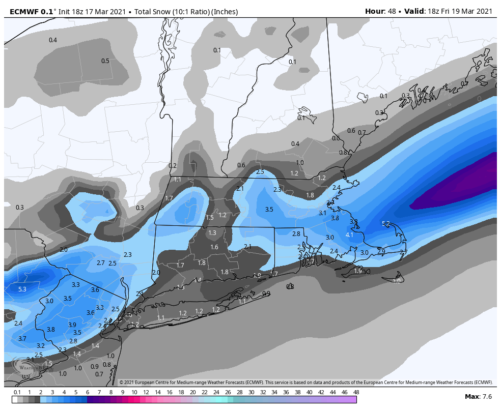
snow map? or at least a generalization on what it has? edit: i got it, stolen from NE forum
-
closer to NYC I'd be surprised if someone gets 4" and even then at elevations.
-
the RAP goes 100% aggressive for us inland folks, delivers 6"+. Obviously sell that, probably not realistic at all.
-
if the RAP actually verifies and delivers me 6" of snow i would be shocked. i would obviously take the under here this far west.
-
I say probable with a range dependent on elevations. You should do well compared to me relatively speaking
-
I say probable with a range dependent on elevations. You should do well compared to me relatively speaking