crossbowftw3
-
Posts
1,324 -
Joined
-
Last visited
Content Type
Profiles
Blogs
Forums
American Weather
Media Demo
Store
Gallery
Everything posted by crossbowftw3
-
6z came back west also I doubt you get 6” of snow when considering this is happening in the morning. Gotta account for sun angle killing ratios. Even if you get moderate snow for 4 hours or so. You need some impressive rates for this time of year to make it stick
-
Upstate/Eastern New York
crossbowftw3 replied to BuffaloWeather's topic in Upstate New York/Pennsylvania
Either way it would seem WWAs would be needed for the rest of BGM/BUF WFOs probably by midday tomorrow -
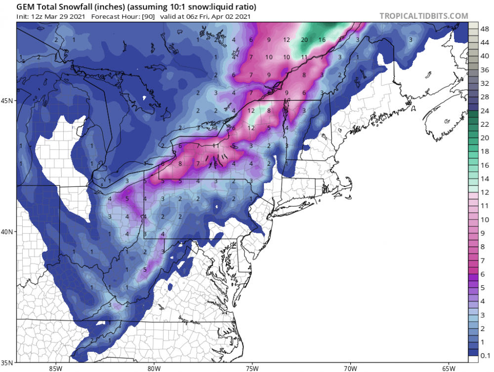
Preferably even closer to Syracuse. They’ll get smacked up there. Pretty high ratios for them too at up to 14:1 (after the initial transition being closer to 4-5:1) so snow growth should be very favorable.
-
If the low was further SE that’s how we get into the 2-5” range for snows here
-
Still possible but CNY is all but locked in for a more significant snow. If we get lucky we can see 2-5” here
-
Upstate/Eastern New York
crossbowftw3 replied to BuffaloWeather's topic in Upstate New York/Pennsylvania
Good luck up there everyone, hoping for at least 10 flakes -
Upstate/Eastern New York
crossbowftw3 replied to BuffaloWeather's topic in Upstate New York/Pennsylvania
That is actually a pretty sizable nationwide outage. The SPC had to post the day 2 severe outlooks in the form of a picture taken of one of the meterologist's phones. -
pretty reasonable guess.
-
If I was chasing snow from this system I would probably be setting up near Syracuse
-
only UKMet has much of anything and even that doesn't get snow close to NYC
-
Upstate/Eastern New York
crossbowftw3 replied to BuffaloWeather's topic in Upstate New York/Pennsylvania
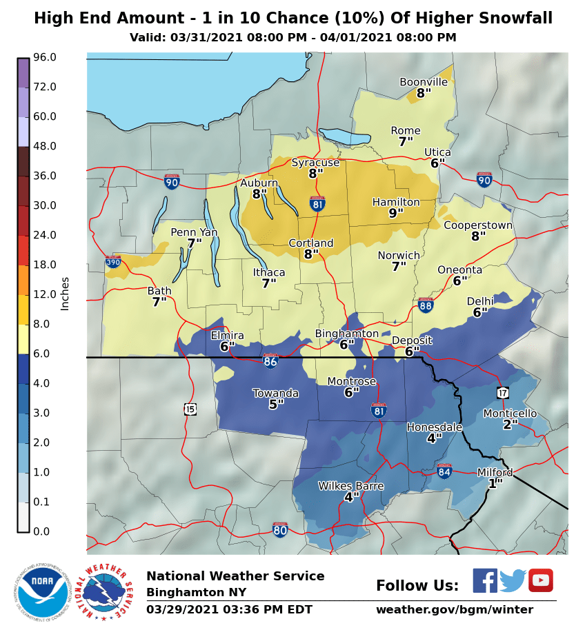
and the HE totals, would be a sizable storm in its own right in January lol

-
Upstate/Eastern New York
crossbowftw3 replied to BuffaloWeather's topic in Upstate New York/Pennsylvania
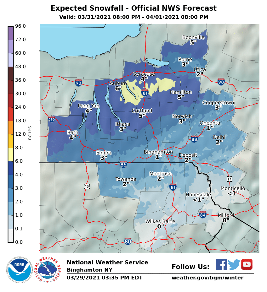
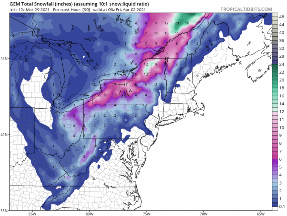
BGM hitting on the potential as well...mentioning potential banding. Won't factor much for me in the SE corner of their CWA but definitely will to the north of here Meanwhile, a surface low will start to develop near Long Island and this low will deepen quickly as it tracks into western New England. The approaching upper level trough starts to become neutral to negatively tilted, slowing down its eastward movement. 12Z model guidance shows an area heavy precipitation developing Wednesday night from Steuben County northeast into the Adirondacks. The latest guidance shows an area of PVA entering western NY and enhancing forcing ahead of a strong 150+ knot jet at 300mb, with the bullseye of the left exit region passing the Western Southern Tier and into the Tug Hill by early Thursday morning. As the column continues to cool Wednesday night, dynamic cooling should cause precipitation to quickly change from rain to snow after 0Z Thursday from west to east. At this time, the highest confidence for possible heavy snow will be in line with the area mentioned above...from Steuben County to Oneida County, where more than 4 inches may fall. It is looking likely that a band of heavy snow is going to set up somewhere, based on the impressive forcing, and amounts could end up much higher where this band ends up.
-
Upstate/Eastern New York
crossbowftw3 replied to BuffaloWeather's topic in Upstate New York/Pennsylvania
12z seems to actually have held serve with this. Could be interesting for you folks closer to the lakes. UKMet for downstate folks like me is our only shot at anything decent. Edit: and even that seems questionable especially if snow falls during daytime thursday as it seems to want to do. -
Upstate/Eastern New York
crossbowftw3 replied to BuffaloWeather's topic in Upstate New York/Pennsylvania
@sferic and I are probably right on the cutoff zone to see any measurable snow regardless -
Canadian for the laughs My area is probably the cutoff for any measurable snow
-
roughly 800' in Sullivan County NY with places like Hawley/Honesdale/Scranton to my west
-
GFS only one that really has any snow for us now and even that is only 1-3" with 4-6" confined north of 90, seeing as how we probably make it to 60 across the area, I would take low
-
Can only hope for 1-2" of slop here on the eastern border of NY/PA but I'll take it to top off our totals.
-
Upstate/Eastern New York
crossbowftw3 replied to BuffaloWeather's topic in Upstate New York/Pennsylvania
Still looks good for us downstate folks to get what might just be our last 1-2” of slop Wednesday night...unless things dry out too quickly for the snow to make it here. -
Starting to look like we might get out last inch or two of slop Wednesday night-Thursday, while further upstate could probably see 3-6”
-
Probably won’t come even close but certainly can count on some snow inland
-
Upstate/Eastern New York
crossbowftw3 replied to BuffaloWeather's topic in Upstate New York/Pennsylvania
At this juncture I figure folks like @sferic and I look to probably be a bit too far away to see anything meaningful outside of perhaps a few sloppy inches -
Today's model runs correcting back to a much more feasible scenario for late week
-
Can I file a motion to make Fake Spring a new Season? Because the instances of false starts have been growing increasingly common nowadays.
-
may i raise the notion of fake spring being an official season? because we sure have been dealing with that a lot lately