

crossbowftw3
-
Posts
1,400 -
Joined
-
Last visited
Content Type
Profiles
Blogs
Forums
American Weather
Media Demo
Store
Gallery
Everything posted by crossbowftw3
-
-
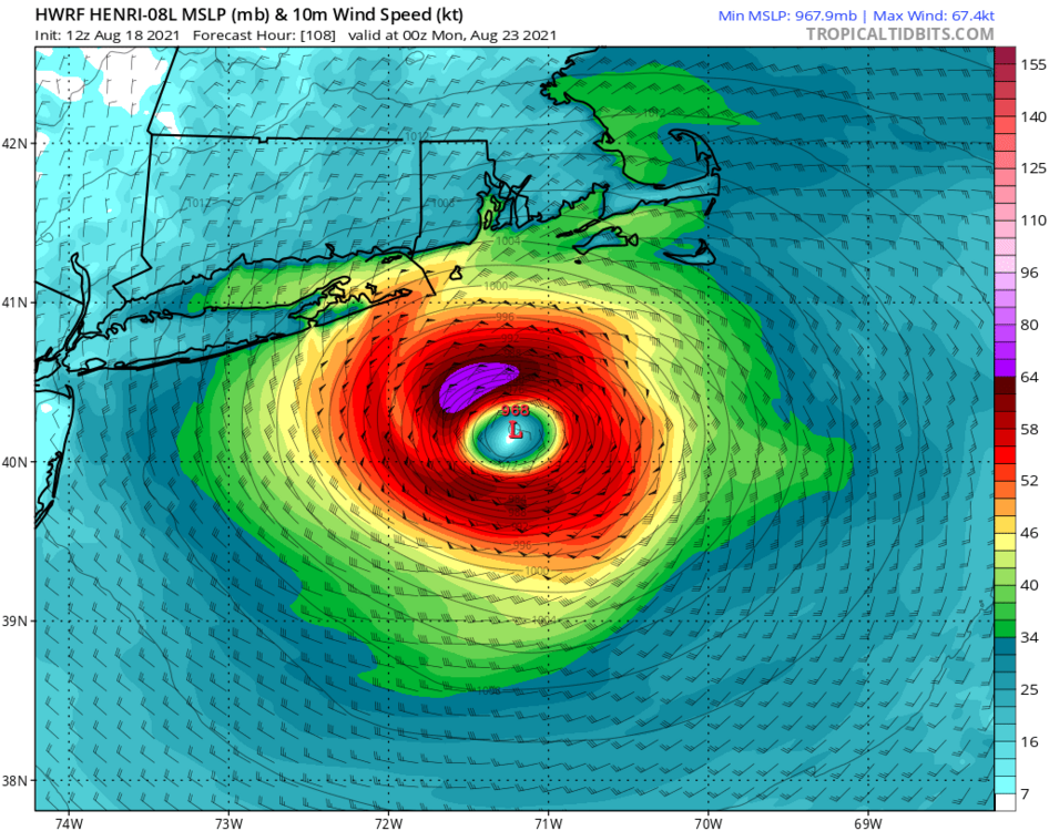
Weakens it from there into what’s probably a transitioning cyclone by 102 hours with an expanding windfield
-
HWRF with a likely beginning to transition cat 1 at 102 hours
-
949mb at maximum and beginning to rapidly weaken on approach at 955
-
Not concerned yet here inland with Henri, but coastal areas should already be getting put on notice.
-
Still looks reasonably good for a quick 1-2” here in Sullivan tonight with the heavier amounts likely to remain NW of here.
-
Certainly a signal exists for 95L to be within that proverbial danger zone for TCs, whether or not it’s a strong TC in 8-10 days time is up for debate.
-
Getting a very early inkling that 95L is shaping up to be the first storm-of-the-season type, although this is obviously way too early for me to say so. Certainly a signal exists for some kind of a TC to exist in 8-10 days time.
-
Beginning to clear out but at a relatively slow pace, 80/74. Once the clouds clear we should be able to take off up here.
-
And commence the “winter is already dead” panic threads
-
Meanwhile it’s been radio silence in the Catskills since the rain shield went through. Absolutely bonkers event that could have been worse had just enough instability been in place.
-
Running very low on time to appreciably destabilize as the rain shield is now under 100 miles away from me.
-
I definitely didn’t agree with the slight northward push of the slight risk at the 8AM update because north of 84 definitely isn’t seeing much severe today.
-
Central PA - Summer 2021
crossbowftw3 replied to Itstrainingtime's topic in Upstate New York/Pennsylvania
Watching from afar today in the Catskills where it looks like we won’t see as much action, I would think those who are in the main target zones need to thin out within the next few hours -
We may get socked in for a good solid while, if it ever breaks. Still not above 70F yet at 10:45 edit: just as I say this the sun is attempting to peek out again, but definitely won’t get the job done to get any substantial clearing going. The rain shield is drawing ever closer and it’ll get to me by 2 PM.
-
Leaning more wet but some isolated severe possible, better threats should be along and south of NYC proper
-
Clouds beginning to win the fight in the Catskills, 68/64, thinking our biggest threat is likely heavy rain now.
-
Should be interesting to see what SPC does here in about 20 minutes, and then by 1630.
-
Clouds should keep severe threat relatively in check north of NYC, southern Jersey looks good for a big day of storms.
-
First signs of possible initiation of the predecessor supercells may be underway across MN soon so we shall see how the models handle the MCS once it gets established, slight risk is good where it stands now. Instability may be limited for us close to and north of NYC proper but shear is notably strong.
-
Moderate risk across Wisconsin this afternoon into night for definite derecho potential. Look at how much instability is already building across MN.
-
So 7/19/19 levels of instability along with the derecho potential from last August, definitely rather eye-popping
-
About to get 7/10 split by a pair of severe warned storms
-
Sun July 11-Mon July 19 Pockets of FF/SVR and a modest heat wave
crossbowftw3 replied to wdrag's topic in New York City Metro
Looks like about 2.5” have fallen thus far per local Obs, still going to be sitting in the stratiform shield for some time further. approximately 10-15” has fallen so far this month, just about double what the two tropical events from last summer delivered for me—Fay at about 2.75” and Isaias at 4.5”. -
Sun July 11-Mon July 19 Pockets of FF/SVR and a modest heat wave
crossbowftw3 replied to wdrag's topic in New York City Metro
The signal definitely exists for someone around these parts to get hit big with rain tomorrow but where exactly remains a mystery. Some severe risk also exists.


