

crossbowftw3
-
Posts
1,395 -
Joined
-
Last visited
Content Type
Profiles
Blogs
Forums
American Weather
Media Demo
Store
Gallery
Everything posted by crossbowftw3
-
I definitely have to be inclined to start believing the flood potential here inland if the center trends any closer to that W-C LI goalpost
-
Inland probably sees very little wind issues, perhaps gusts to 40 in the typical elevated spots. Rain, and potentially lots of it, is the major issue for us inlanders.
- 1,603 replies
-
- 1
-

-
- hurricane gusts
- flooding rains
- (and 2 more)
-
W-C LI is probably the furthest west this can get. Don’t see a direct NYC LF but even a landfall near ISP gets NYC proper into TS conditions but likely not much further west than that
- 1,603 replies
-
- 1
-
-
- hurricane gusts
- flooding rains
- (and 2 more)
-
Kevin doing mud angels in his backyard while transformers blow all around? Sounds festive
-
And that’s the most concerning part of all of this right now, don’t think many people are taking well to waking up with hurricane watches
-
Central/Western LI is the limit for how far this gets pulled in, still believe Montauk to the Cape is the main target zone, goalposts to be narrowed further today
-
If Jim rolls up in Islip watch out, lol
-
Not even 100 but hurricane force certainly possible in coastal areas.
-
Not even close to either...it’ll be bad over a much more localized area than Sandy. For >80% of the northeast it’ll be NBD.
-
This is why NAM should never be used to track a TC. From 880 monsters in the gulf to 922 off the Delmarva, what other shenanigans will it cook up next
-
Looks to be a final storm total of around 2” if the LSR from about 10ish minutes west of me is to be correct. MA/CT getting dumped on this morning and if Henri stalls there big problems will ensue. Seeing reports of 3-5”+ there.
-
Think smaller scale Allison (2001) or Harvey in that case
-
At this stage of the ballgame I would be inclined to lean closer to a New England track with some impacts for LI. How many more ticks west to get NYC into the game is the question. For those of us N&W of the city proper and further inland this is likely not our game.
-
It could swing back closer to deliver something to NYC but at this point a New England strike is beginning to look more likely than it did 12-24 hours ago
-
That’s my idea as well for the moment. Ultimate reality probably doesn’t stray from that, but maybe 25-50 or so miles of error.
-
We really can put a feather in our caps that these waters will (almost) always destroy every slow-moving TC that attempts to move through.
-
Major flooding potential for anywhere this just sits and spins new convection in conjunction with surge flooding.
-
That’s the school of thought being presented, any strong TC would need to absolutely book it to prevent weakening in these waters. In 36-48 hours a strong cat2/3 quickly weakens to a cat 1 that’s likely commencing an ET transition because of the slower movement speed. Surge and freshwater flooding would get exacerbated if/where this thing decides to park itself.
-
This entire subforum is in the game for now but I would anticipate some pushes back East until we settle in on one common solution. As others on the NE thread are noting wind threat probably won’t be the major stickler but flooding—surge and fresh—would be exacerbated.
-
Beginning to think that if everything holds in the next 48/72 hours LI and East interests need to think about preparing—fairly sizable TS force wind area at this time with a 75kt cat1/transitioning cyclone pushing ashore at least with the HWRF considered.
-
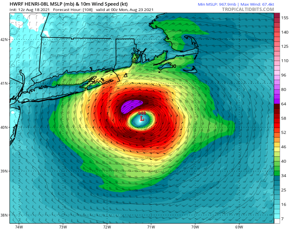
-
Weakens it from there into what’s probably a transitioning cyclone by 102 hours with an expanding windfield
-
HWRF with a likely beginning to transition cat 1 at 102 hours
-
949mb at maximum and beginning to rapidly weaken on approach at 955
-
Not concerned yet here inland with Henri, but coastal areas should already be getting put on notice.


