crossbowftw3
-
Posts
1,401 -
Joined
-
Last visited
Content Type
Profiles
Blogs
Forums
American Weather
Media Demo
Store
Gallery
Everything posted by crossbowftw3
-
Some incredibly persistent patches of snow remain in and around my yard this morning. Hard to fathom most of those stick around by the end of the day today, much less the first several days of next week. I am personally very much wondering what kind of last act this winter will provide for us, considering I’m absolutely not going to hit my average for this winter (MSV average ~65 inches, not even 1/3 of that has fallen to this point) barring a series of miracles in March
-
Nothing wrong with pulling a 3-6/4-8 event this deep into winter to at least remind us that winter isn’t quite done yet, right?
-
Seeing potholes popping up all around the roads here in Sullivan as well.
-
ZR/IP mix now with the snow line about 15-20 miles away. Maybe a quick coating to end this?
-
And it now looks like I’ve fallen below 32 for real, at almost lunchtime. Any accretions will happen within the next few hours and that’s probably it.
-
Just as a note, this report came in from NEPA. It’s certainly accreting somewhere. Location: LAKE ARIEL, PADescription: Freezing RainMagnitude: 0.80 INCHReport Time: 09:00 am EST - 2/4/2022Remarks:
-
Central PA - Winter 2021/2022
crossbowftw3 replied to Bubbler86's topic in Upstate New York/Pennsylvania
Anyone able to confirm/have ground truth of this ZR report from Lake Ariel? Location: LAKE ARIEL, PADescription: Freezing RainMagnitude: 0.80 INCHReport Time: 09:00 am EST - 2/4/2022Remarks: -
And as I wrote this I see BGM got a report of .8” of ZR (definitely flat, so it works down to maybe .3-.4?) in Lake Ariel, not that far away from me. The difference? About 800 feet of elevation.
-
I’m also at 750ish feet. Not sure, but everywhere around me with more elevation definitely has been icing this morning. These elevation gradients always play a part in what sensible weather I see around here but I was for sure certain we’d see at least some ice this morning.
-
It absolutely refuses to drop below 32F at 32/29, still no visible icing that I can spot.
-
Probably, lol
-
Still predominantly rain here, which continues to be remarkable. It’s a very precarious position to be in, though. Meanwhile, younger sibling had to deal with a fire drill at Oswego…in the middle of the night…during the snow.
-
Still holding shockingly well between 32-35 depending on where I look with relatively no signs of icing where I’m at in Sullivan. It’s 100% a whole different story at elevations…
-
Feb 2-4th Snowstorm- Observation Thread
crossbowftw3 replied to BuffaloWeather's topic in Upstate New York/Pennsylvania
Meanwhile: I’m in the middle of a pretty remarkable situation down here in Sullivan, where I’m still by and large all rain where everywhere around is icing, with temps between 32 and 35 depending on where I look. Can’t imagine that stays for any more than another hour or two. -
Remarkably still holding between 32-35 depending on where I look and it still sounds like just plain rain with maybe the slightest hint of ZR mixing in. Should be going all the way over soon though, and lasting through the morning.
-
Latest meso models continuing with the idea that at my house in Sullivan I might not go below 32 until after sunrise. Still is going to be a tight squeeze with all of the elevations (again, Sullivan County is nothing but elevations >1k feet) around me probably icing much sooner.
-
My pack is getting beat on right now with temperatures right between 41-42. No way it survives the rest of today at this rate
-
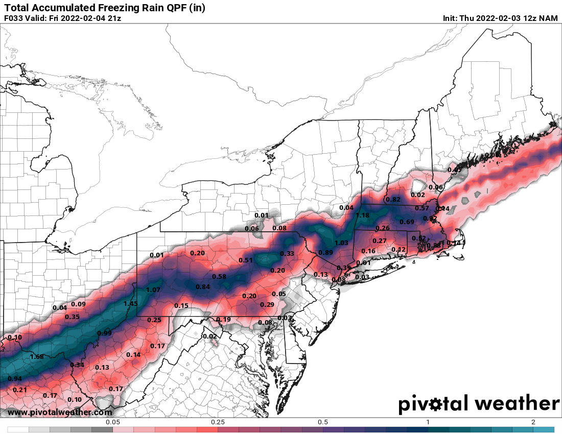
As a reminder, the QPF maps cannot be taken 100% verbatim. Chop them down by 30-40% and you come away with the likelier results.
-
The relative hole in ZR accumulations represents my relatively lower elevation in Sullivan so well on the 12z NAM. Not like I’m complaining
-
12z HRRR printing out 1.3” of liquid in ZR for elevations of Ulster and Dutchess Counties, which would work to being dangerously close to the .5” marker for an ISW.
-
Watch swapped to an advisory for up to .25” but I doubt areas around here get away with only seeing that. Similar gradient to 12/29/19 showing up on meso models as well where I saw almost no ice, while 30-40 minutes and elevation saw up to .4”.
-
Winter storm watch for .25-.5” of ice. Excellent….not
-
Feb 2-4th Snowstorm- Observation Thread
crossbowftw3 replied to BuffaloWeather's topic in Upstate New York/Pennsylvania
Instead of the good stuff I’m at risk of .25”-.5” of ice accretions have fun with the good stuff -
Winter storm watch now for .25-.5” and 1-3 of snow. At my lower elevation it’s likely closer to the .25” than the .5” but… Good thing is that there should be almost no wind factoring in so any outages probably wouldn’t last longer than 2-3 days at most
-
They typically never do. Common rule is to cut QPF maps by 35-40% to get totals and that’ll get a wide enough area to .25” or more which still will prove to be a gigantic problem.