Kmlwx
-
Posts
13,597 -
Joined
-
Last visited
Content Type
Profiles
Blogs
Forums
American Weather
Media Demo
Store
Gallery
Everything posted by Kmlwx
-
Any reason that it seems to be more prominent this season than prior ones? Or is that just recency bias?
-
Our vantage point looks super similar - I could probably yell our "SNOWFAN" and you might hear it.
- 1,496 replies
-
- 1
-

-
- severe
- thunderstorms
- (and 7 more)
-
It seems like LWX will warn a huge swath and then if an area of considerable or destructive nature shows itself they will put a warning inside of the warning. I can see it from both sides...I think they do it because of the metro corridor honestly.
- 1,496 replies
-
- 1
-

-
- severe
- thunderstorms
- (and 7 more)
-
It's interesting because anecdotally we have seen them bring through robust lines only for relative minimums to occur in swaths of our area. But yeah - this has been an interesting season of modeling.
-
The shape of the velocity signature sort of makes me think there's a slight chance of a little kink or enhanced area that may be prone to spin briefly. But certainly not a strong tornado risk or anything - maybe more like a gustnado if that keeps up.
-
- 1,496 replies
-
- 4
-
-
- severe
- thunderstorms
- (and 7 more)
-
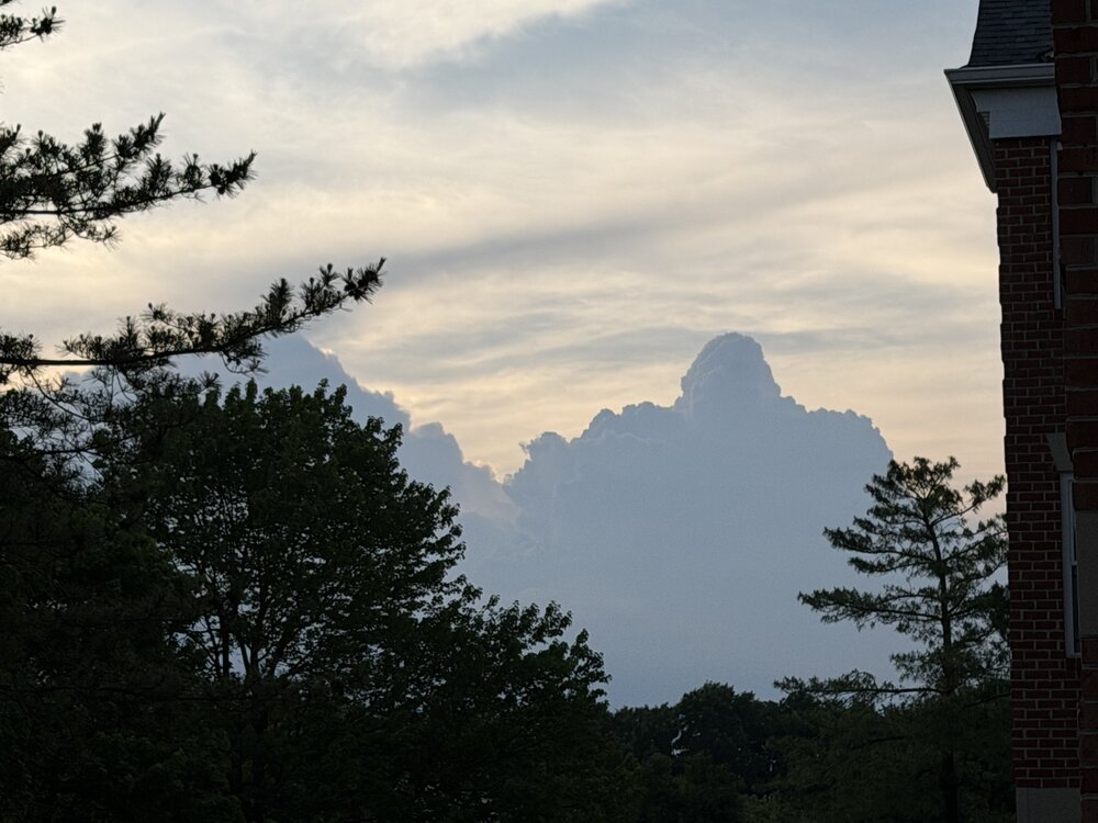
Next segment of the area warned now. can see the profile of the storms looking west from Odenton, MD right now. Looks cool!
- 1,496 replies
-
- 1
-
-
- severe
- thunderstorms
- (and 7 more)
-
The LWX specialty warning size lol
-
The timing may be after daytime heating is subsiding - it's possible that instability could become more elevated versus surface based is my assumption.
- 1,496 replies
-
- 1
-

-
- severe
- thunderstorms
- (and 7 more)
-
The HRRR which had looked impressive for tomorrow afternoon no longer does with the 12z run - unless you are south of DC.
- 1,496 replies
-
- 2
-
-
- severe
- thunderstorms
- (and 7 more)
-
Heck…even June 29, 2012 was one LOL
-
Some of my most memorable severe days started out as SEE TEXT lol. Bring it.
-
I was actually just thinking that this is likely more a factor of the new categorical risk areas/percentages than anything. Especially now that they can go even higher on percentages on wind...30% at day 3 is nothing to sneeze at - but I think it will become a lot more common with these new outlooks. Also no CIG hatching at all.
-
Not fully shocked but that’s pretty robust from SPC at range
-
Quite a bit of initiation happening on the higher terrain to the west.
- 1,496 replies
-
- 1
-
-
- severe
- thunderstorms
- (and 7 more)
-
Someone (or a few people) in the next few days - will get microbursted I think. But probably not a region-wide event.
-
HRRR actually has something coming through Central Maryland this afternoon.
- 1,496 replies
-
- 2
-
-
- severe
- thunderstorms
- (and 7 more)
-

-
@Ian was always overrated - meh. All kidding - missed you, dude!
-
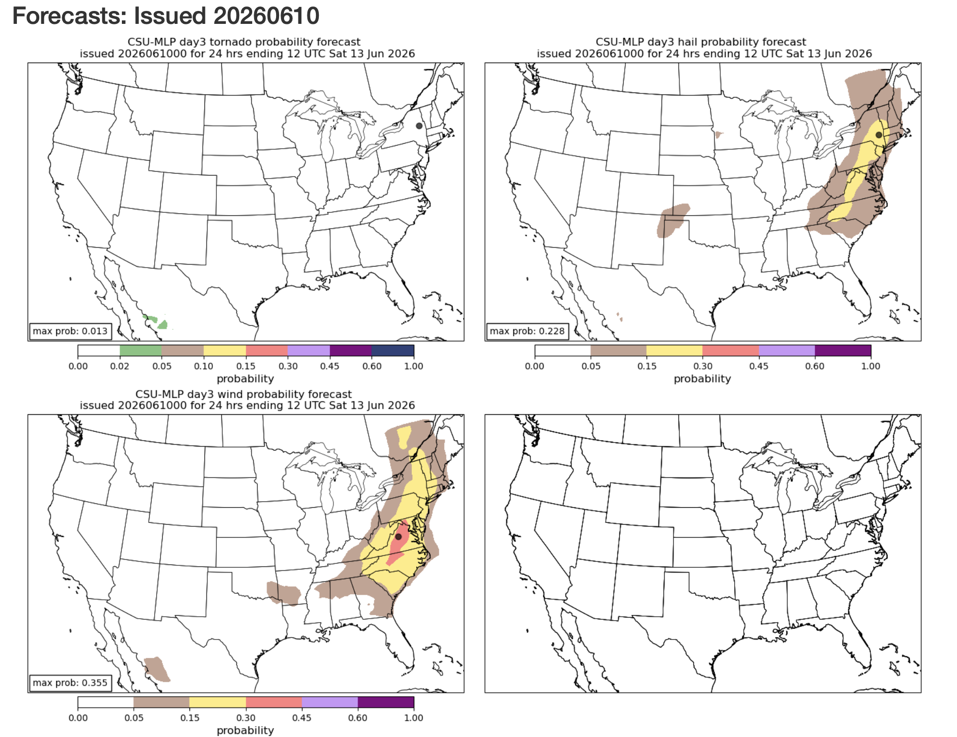
Friday is getting more robust on the CSU MLP page as well - area of 30% showing up.
- 1,496 replies
-
- 1
-
-
- severe
- thunderstorms
- (and 7 more)
-
The one thing that can elevate a normally garden variety threat would be if the outflow from storms can really make a robust cold pool that propagates off the terrain and gusts out. I don't think we'll have a solid handle on how the day(s) will play out until each one is on top of us.
-
Total gut feeling (no science involved) but it feels like the stretch of days where a few people get absolutely smoked by a wind damage core or two and the rest of us maybe hear distant thunder or see mostly sunny skies.
-
Day 2 marginal, Day 3 marginal and day 4 15%
- 1,496 replies
-
- 3
-
-
- severe
- thunderstorms
- (and 7 more)
-
And yeah a deep trough to our west would be a recipe for potential action for sure!
- 1,496 replies
-
- 3
-
-
- severe
- thunderstorms
- (and 7 more)
-
The GFS hinted at some remnant EML advection perhaps on Thursday as well - but we all know that can change with shorter leads.
- 1,496 replies
-
- 1
-
-
- severe
- thunderstorms
- (and 7 more)