Kmlwx
-
Posts
13,026 -
Joined
-
Last visited
Content Type
Profiles
Blogs
Forums
American Weather
Media Demo
Store
Gallery
Everything posted by Kmlwx
-

2023 Mid-Atlantic Severe Wx Thread (General Discussion)
Kmlwx replied to Kmlwx's topic in Mid Atlantic
At work in Potomac/Rockville - but PWS at home is showing 81.7 temp and 72.2 dew. At least for the moment - MBY at home is still okay on the dew side of things. -
2023 Mid-Atlantic Severe Wx Thread (General Discussion)
Kmlwx replied to Kmlwx's topic in Mid Atlantic
It's almost like a pity meso disguised as a good one -
2023 Mid-Atlantic Severe Wx Thread (General Discussion)
Kmlwx replied to Kmlwx's topic in Mid Atlantic
Bold probs! -
2023 Mid-Atlantic Severe Wx Thread (General Discussion)
Kmlwx replied to Kmlwx's topic in Mid Atlantic
Pretty abysmal hail risk in our region now on the probs, however. Enhanced for wind still, of course. The SPC discussion is a little meh worthy honestly. -
2023 Mid-Atlantic Severe Wx Thread (General Discussion)
Kmlwx replied to Kmlwx's topic in Mid Atlantic
I'm glad we didn't elevate this beyond Yoda level on the @WxWatcher007 scale. Does this mean we outperform SPC?!?! We'll see the final answer by later on.- 2,785 replies
-
- 1
-

-
- severe
- thunderstorms
- (and 3 more)
-
2023 Mid-Atlantic Severe Wx Thread (General Discussion)
Kmlwx replied to Kmlwx's topic in Mid Atlantic
@high risk - definitely a wait and see kind of thing but I have noticed a really big change in the sim reflectivity maps for much of the modeling for the greater DC area. It almost looks like the better chance of storms is tomorrow on the NAM nest for some of us. Oddly enough - there was some indicating in CIPS guidance that tomorrow would be a stronger event. Would be funny if that happened. Horribly boring stretch we are in if these few days fail - other than smoke we have had barely a thing to track. -
2023 Mid-Atlantic Severe Wx Thread (General Discussion)
Kmlwx replied to Kmlwx's topic in Mid Atlantic
If nothing else - DCAPE is starting to crank up over Central Maryland.- 2,785 replies
-
- 1
-
-
- severe
- thunderstorms
- (and 3 more)
-
2023 Mid-Atlantic Severe Wx Thread (General Discussion)
Kmlwx replied to Kmlwx's topic in Mid Atlantic
Really a no-win situation -
Has anyone heard of any flyovers for the DMV region for tomorrow's Operation Centennial Contact (KC-135s etc). PA is doing one but the DC area hasn't released any plans or info. Looks like Gettysburg may be the closest pass - would be a bit of a drive to go see especially on a workday...
-
2023 Mid-Atlantic Severe Wx Thread (General Discussion)
Kmlwx replied to Kmlwx's topic in Mid Atlantic
HRRR is still pretty meh -
2023 Mid-Atlantic Severe Wx Thread (General Discussion)
Kmlwx replied to Kmlwx's topic in Mid Atlantic
We can still fail (I know I'm echoing what we all know already) - but the @Eskimo Joe failure mode of just no sun is not going to verify. If we fail it will be from something else.- 2,785 replies
-
- 1
-

-
- severe
- thunderstorms
- (and 3 more)
-
2023 Mid-Atlantic Severe Wx Thread (General Discussion)
Kmlwx replied to Kmlwx's topic in Mid Atlantic
There were some peaks of sun on my drive into the office (Colesville to Rockville/Potomac). -
2023 Mid-Atlantic Severe Wx Thread (General Discussion)
Kmlwx replied to Kmlwx's topic in Mid Atlantic
The good old fashioned DC screwjob essentially. Have seen it on more than one CAM overnight...I'd almost say that's becoming semi-likely with some crapvection/junk in between. -
2023 Mid-Atlantic Severe Wx Thread (General Discussion)
Kmlwx replied to Kmlwx's topic in Mid Atlantic
The dewpoint here is 71 at this time. If we can avoid that dropping too much, and can manage some sunshine we should be set for something semi-decent. All a balance...we can probably deal with less of one thing if there is enough of another factor present. I can see @Eskimo Joe's concern - and certainly does seem that best sunshine will be S of I-66 but the threat is not greatly reduced as of yet. At least IMO. -
2023 Mid-Atlantic Severe Wx Thread (General Discussion)
Kmlwx replied to Kmlwx's topic in Mid Atlantic

- 2,785 replies
-
- 1
-
-
- severe
- thunderstorms
- (and 3 more)
-
2023 Mid-Atlantic Severe Wx Thread (General Discussion)
Kmlwx replied to Kmlwx's topic in Mid Atlantic
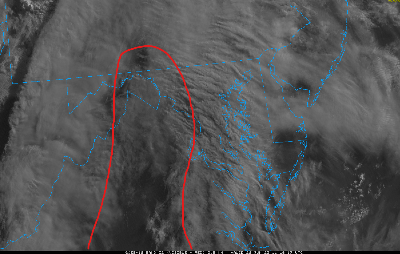
Matches what the HRRR runs last night were showing. Band of clouds in the morning but potential clearing by later morning/afternoon. Question is will it be soon enough. Visible satellite shows promise with a nose of clearing in Virginia - it appears (unless it's a shadow) extends up all the way into the Panhandle of WV and Maryland and even into a sliver of S PA. It's still early enough for clouds to resolve. If it was 10am and we are still socked in - sure. -
2023 Mid-Atlantic Severe Wx Thread (General Discussion)
Kmlwx replied to Kmlwx's topic in Mid Atlantic
Some of the CAMs are uninspiring for a chunk of us. In fact, the latest NAM nest (6z) - largely missed DC proper with anything substantial and focuses most north and east of the city. Anne Arundel and Baltimore and north look good still on that run. -
2023 Mid-Atlantic Severe Wx Thread (General Discussion)
Kmlwx replied to Kmlwx's topic in Mid Atlantic
HRRR does have pretty substantial cloudiness for much of the morning for our region. If we are looking only at dews...would think that 70+ could net us an impressive day (verification of the ENH risk). Mid 60s perhaps would verify us in the slight risk, and if the HRRR is completely right - general thunderstorms with some gusty winds perhaps. In reality - more factors go into it (MLLR, shear etc) - but dews will be a big deal tomorrow.- 2,785 replies
-
- 2
-
-
- severe
- thunderstorms
- (and 3 more)
-
2023 Mid-Atlantic Severe Wx Thread (General Discussion)
Kmlwx replied to Kmlwx's topic in Mid Atlantic
0z HRRR continues with the lower dews for many of us. Has dews down as low as the upper 50s for some spots even pre-storms tomorrow. That will likely impact the rest of the run and subsequent storm chances for us. -
2023 Mid-Atlantic Severe Wx Thread (General Discussion)
Kmlwx replied to Kmlwx's topic in Mid Atlantic
That's a micro/mesoscale occurrence. Anecdotally I think we all tend to think the gaps happen over us. In reality, it's probably terrain/orographic in nature. Gaps in storms are normal - consider in hurricanes when a major eyewall is in place - the area immediately surrounding can often have subsidence (particularly during an eyewall replacement cycle. The concept of "storms robbing energy" is sort of true. If you have a massive lone cell, and no cold pool or meteorological reason for it to grow upscale into a line segment/squall line, it may "use up" energy for other storms around it - often it will impact the inflow for another potential storm. There's also, of course, the outflow racing out ahead that can cause storms to die off and then "jump over" a given locale as the outflow triggers new storms.- 2,785 replies
-
- 5
-

-
-
- severe
- thunderstorms
- (and 3 more)
-
2023 Mid-Atlantic Severe Wx Thread (General Discussion)
Kmlwx replied to Kmlwx's topic in Mid Atlantic
I certainly find it hard to believe that there will be fewer than 5 severe reports in the LWX area tomorrow. But we'll see. -
2023 Mid-Atlantic Severe Wx Thread (General Discussion)
Kmlwx replied to Kmlwx's topic in Mid Atlantic
Weenie-ism = It's underperforming today so that the juice can be saved for our event tomorrow.- 2,785 replies
-
- 3
-
-
-
- severe
- thunderstorms
- (and 3 more)
-
2023 Mid-Atlantic Severe Wx Thread (General Discussion)
Kmlwx replied to Kmlwx's topic in Mid Atlantic
Not questioning the SPC - but I would have held off on that hatching until a subsequent outlook. Adding it on the initial D2 and removing it on the updated D2 is less ideal than just leaving it off until confidence is higher. As others have already said - I think the failure modes for us are still present. The mid-level lapse rates (if they come to fruition) should at least be able to give us some "wiggle room" for exciting weather. Unless we get a huge squall line stretching the entire area - some places (as always) will get shafted. That being said...my thoughts remain largely unchanged. I think this is our best severe weather threat in some time now. If the NAM moisture and HRRR moisture met in the middle - probably would still yield a decent setup. All will come down to nowcasting as it often does here. Will be interested to see how the models look at the 0z suite and even the 6 and 12z runs tomorrow. Lots of eyes will be on the dewpoints during the morning and the mesoanalysis page. I know we all cringe at trying to "forecast" the SPC. But I'd put my two cents in that the D1 outlook overnight for tomorrow will be largely unchanged from right now - unless guidance suggests some huge change or outbreak. Wouldn't be surprised to see the hatched hail come back at some point - the SARS analog data getting spit out on some forecast soundings is quite impressive on hail size. OT - but tomorrow is one of my in-office days of the week. And I'm in until 5:30pm...really hoping I can either duck out early...doubt it, though.- 2,785 replies
-
- 9
-
-
-
- severe
- thunderstorms
- (and 3 more)
-
2023 Mid-Atlantic Severe Wx Thread (General Discussion)
Kmlwx replied to Kmlwx's topic in Mid Atlantic
I'm not officially on board yet. I'll take a look this evening. -
2023 Mid-Atlantic Severe Wx Thread (General Discussion)
Kmlwx replied to Kmlwx's topic in Mid Atlantic
If my memory isn't failing me yet (it probably is) I do think that the HRRR had a tendency in past severe seasons to pull dew points way too far down. But I'm sure the NAM could be too moist.- 2,785 replies
-
- 2
-
-
- severe
- thunderstorms
- (and 3 more)