

Kmlwx
-
Posts
13,203 -
Joined
-
Last visited
Content Type
Profiles
Blogs
Forums
American Weather
Media Demo
Store
Gallery
Posts posted by Kmlwx
-
-
The 18z 12km NAM looks great if I'm being honest. really nice sim reflectivity, especially for it being the 12km resolution. Of course...it's the NAM at range. I hope the lackluster 12z GFS run was a blip...we'll see here soon.
Frankly...if we took the 18z NAM at face value...I'm guessing it would be a ENH day if not higher.
-
 2
2
-
-
43 minutes ago, Eskimo Joe said:
Oooo...can you share the new tables?
I've been downloading from here -
-
1
-
 1
1
-
-
1 minute ago, Eskimo Joe said:
IMO, there are too many mesoscale features in these parts to accurately define severe weather risk beyond D2. I'll be back in Maryland Sunday afternoon and hope to see some storms next week.
Good news is that at a minimum we should have chances at a few rounds of storms late weekend and into the holiday. While that potential squall line Sun night into Mon AM could spoil Mon afternoon, seems odds for storms for most are pretty high. Remains to be seen what the actual severe potential looks like. I got all my GR products updated and downloaded some new color tables....so I probably jinxed us.
-
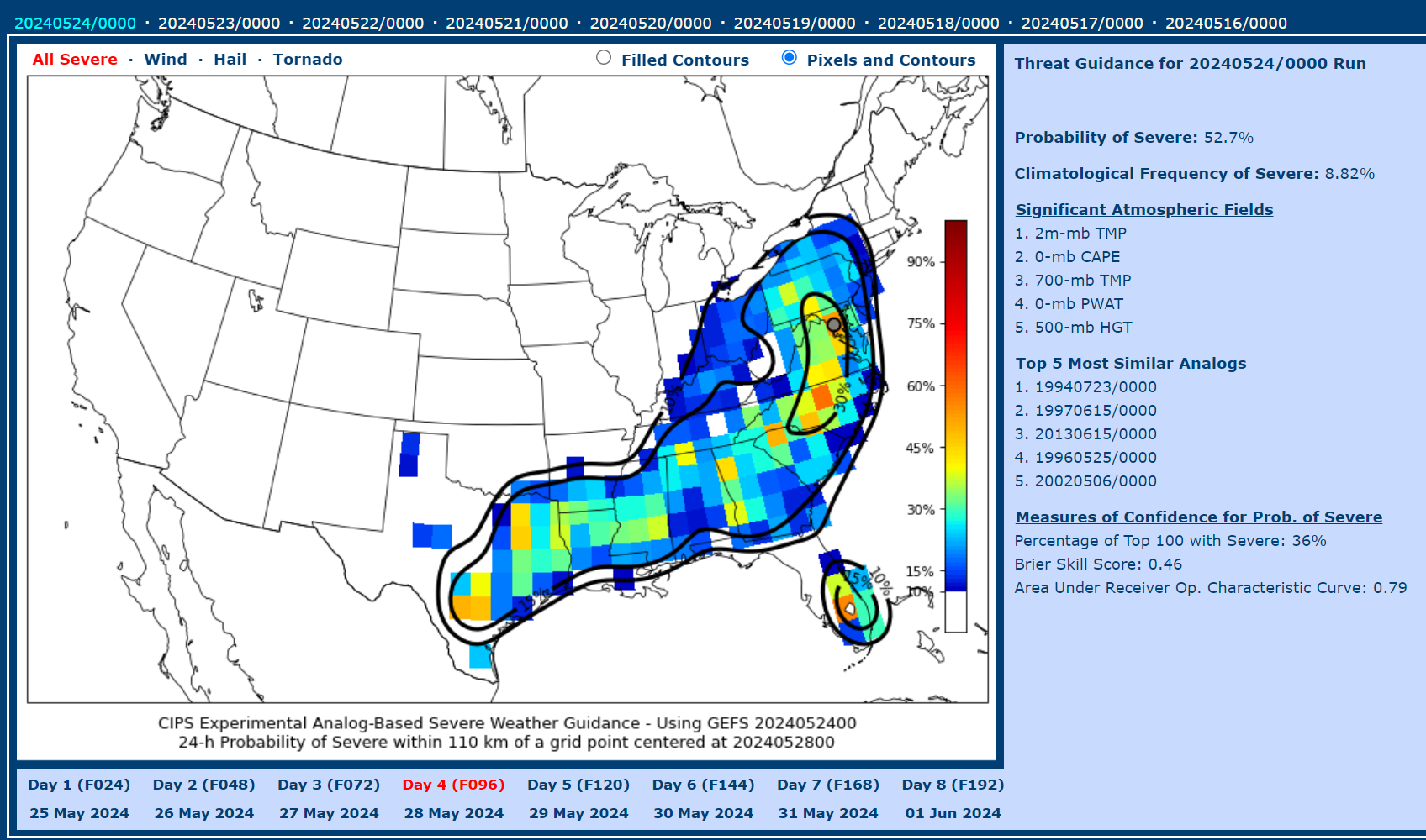
12z CIPS at hour 84..if you cheat a little and use the Southeast Domain instead of the one over us, April 29, 2002 at 0z is the top analog (La Plata event). Also one of the June 1998 beefy events showing up. Overall the CIPS guidance looks more robust at the 12z run versus the overnight run. I was pretty enthusiastic with how the Euro looks latest run too.
-
2
-
-
12z GFS backed wayyy off on the Monday threat. Instability looks much lower. This is why we can't "bank on" anything days out ahead. We'll see how things look later in the weekend.
-
June 2013 (the big event) is showing up in the analogs

-
1
-
-
4 minutes ago, yoda said:
18z GFS looks like a significant severe weather episode for us Monday afternoon/evening
The supercell composite maps have improved a decent bit from prior runs. If that continues to look good or even improve, I'll be on board. Still a bit too far out to be at all confident.
-
2
-
-
7 minutes ago, Amped said:
I haven't been looking at weather maps for a while. I am impressed with modays setup.
If @Amped is excited - that's usually a good indication for severe.
-
5 minutes ago, high risk said:
It's worth noting that SPC used to be very liberal with issuing Moderate Risks. We had 3 here in a two-week period in some year in the early 2000s. They eventually added the Enhanced category so that they could save the Moderate for legitimate higher-end events.
I wish had had a better memory of the sequence of late May to early June 1998. I wasn't THAT young...but for some reason I just can't remember specifics. My memory starts to become clearer starting around the Sept 2001 College Park tornado...but before that...really blurry if any memory at all.
June 2008 seemed like a decent "heater" period along with June 2012.
-
7 minutes ago, yoda said:
I will have to look it up after I get home from work... and I was 3 years old

October 18th of that year (1990) had an outbreak as well. Most of what I can find are write-ups that might not be DC area centered and archived articles from the WaPo and similar.
-
Using MBY in Silver Spring/Colesville as a point, the IEM SPC Outlook filtering guide shows *TEN* moderate risk days from May to October in 1990. Obviously, meteorology wasn't advanced as it was...but that was either a heck of a bust year or we were absolutely getting rocked and rolled. I wasn't born yet
-
CIPS is a little less enthusiastic on the 0z overnight run. But it will wax and wane I'm sure.
I was doing some boredom research and it definitely looks like the idea that we go on heaters followed by long periods of "meh" severe weather is legit - at least judging solely by SPC outlook categories.
I found some stretches in the 90s of heater runs of moderate risks in a month period. Wish I was old enough to distinctly remember those. SPC Outlook archives on their website only go back to 2000 - Googling can get you some but not a comprehensive list of pre-2000. Fun to do in free time. Nerds....we are.
-
3
-
-
Who knows when the next time we'll see a TOR driven moderate risk around these parts. Exceedingly rare.
-
1
-
-
From June 1, 2012

-
4
-
-
6 minutes ago, George BM said:
What analogs are they showing?
Lots of nothing...BUT the domain that is centered over us has the following:
For the 84hr mark: June 24-25, 1996 (multiple tornado day in NoVA), June 2-3, 1998 (big time eastern US tornado outbreak - also quickly followed the May 1998 derecho outbreak).
For the 132hr mark there are two domains mostly overlapping each other. Doing some pick and choose shows June 1-2, 2012 and April 27/28/29 event in 2011.
-
4
-
1
-
-
Don't look now but the 12z CIPS guidance has some excitement at the 84hr frames and the 132hr frames.
-
2
-
-
18 minutes ago, 09-10 analogy said:
Yeah, it seems pretty rare for an AFD to start honking about a severe threat almost a week away. Hope things evolve so that the threat is a little later in the day on Monday; that is, if it comes to fruition at all.
The one thing is that they probably mean substantial relative to this week's threats (which seem marginal for now). So "more substantial" could mean just a step above that.
-
At this point I'm pretty meh on the remainder of the week. We'll see about Thursday. Intrigued (for now) on Monday. Doldrums around here lately.
-
Would be cool to see ARs 3676, 3683, 3674, 3679 and the group just emerging into view form the east limb all merge and grow into a sunspot group to end all sunspot groups.

-
1
-
 1
1
-
-
Paging @Eskimo Joe - the 18z GFS throws at least some semblance of better-than-normal mid-level lapse rates our way a few times next week.
-
2
-
-
GFS is very lame (in terms of parameters) though nearly the end of the run. Will see how this changes the in the coming days.
-
36 minutes ago, high risk said:
Right, but northern stream events here early in the season often struggle with instability, as it's tough to get good low-level moisture north at this time of year without some help.
I'm a little more optimistic the later into May we get. Obviously, it would be helpful is we had June heat/humidity available.
-
2
-
-
12 minutes ago, yoda said:
Do northern stream s/w's bring about our better severe weather threats? There was an interesting tidbit at the end of this mornings AFD
Upper level ridging tries to build back into the area Sunday into
Monday bringing slightly drier conditions. Another front will follow
with renewed chances for showers and thunderstorms Tuesday and
Wednesday next week. Temperatures will continue to warm back above
average during this time leading to the potential for greater
instability for thunderstorm activity to feed off of. With a fairly
active northern stream will continue to monitor for any severe
weather or hydro threats within the extended period. Right now,
there is no mention in the Day 4-8 outlook from the Storm Prediction
Center.
NW flow comes to mind. That could be what they are referencing. If a little kink in the flow can come at us at the right angle, perhaps even with some EML advecting from the west, we could do very well. GFS has teased us with a few potential threats in the fantasy ranges the last few runs.
-
1
-
-
4 minutes ago, NorthArlington101 said:
Don’t think anyone really knows, but the NWS SWPC says CMEs will arrive “later today” — I guess if it was late enough we’d have a shot.
https://x.com/nwsswpc/status/1789647663484334251?s=46&t=YRAxGyE8QLsoshMtJniktgIf anything I'd expect it to run early rather than late. The earlier CMEs probably cleared things out enough to allow a faster forward speed. But space weather is fickle and unpredictable...even more so than Earth weather!
-
1
-
2024 Severe Weather General Discussion
in Mid Atlantic
Posted
One other thing about the 18z NAM soundings....the SARS numbers/results have been steadily getting more impressive. It's gone from 40-50% in the TOR and hail columns to now into the 50-60+ percent range.