Kmlwx
-
Posts
13,591 -
Joined
-
Last visited
Content Type
Profiles
Blogs
Forums
American Weather
Media Demo
Store
Gallery
Everything posted by Kmlwx
-
Line of storms over/near you.
- 1,378 replies
-
- 1
-

-
- severe
- thunderstorms
- (and 2 more)
-
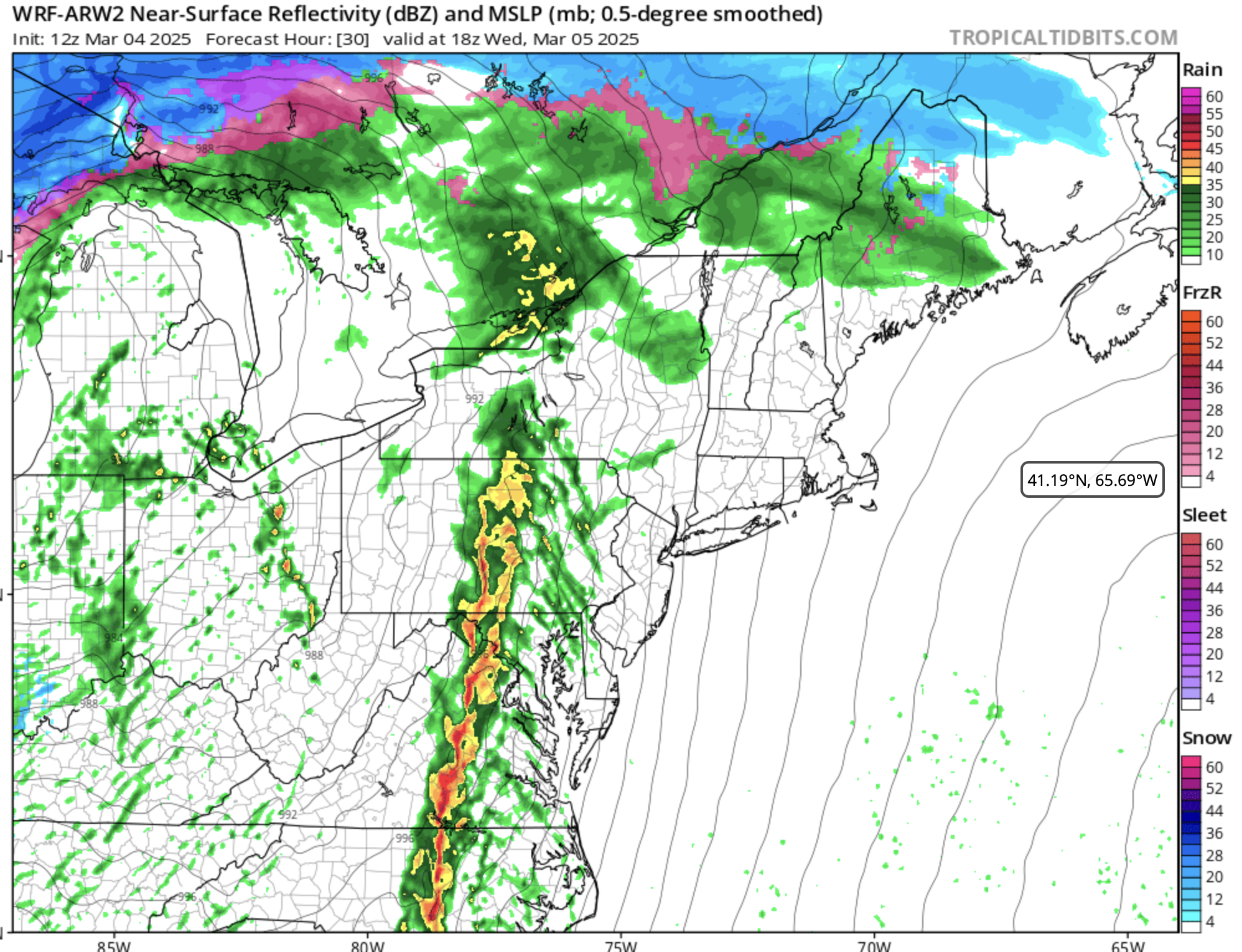
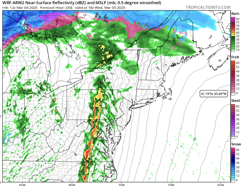
Mostly expecting that to be the case- though the HRRR sometimes underdoes convection. Wouldn't shock me to see an isolated rumble of thunder mainly west of US-15
-
Already lightning with the cells near Mill Creek. WV.
-
Let's see if this precip can clear out quickly enough to get a 2nd round into the closer-in areas later. For now - way west is still favored.
- 1,378 replies
-
- 2
-

-
- severe
- thunderstorms
- (and 2 more)
-
Anne Arundel and PG added to the watch.
-
TIAD radar is seeing some 60-65mph wind just under 2kft. Not sure if much or any of that is mixing down though.
-
These days you could probably say "rain and a little fog" and schools would dismiss.
-
Wow
-
Can't even do gusty showers right, I guess
-
Obs show that our temps and dews are not wildly different from the areas under the MCD. Not saying we have the totally same environment - but it's not like a 10-15 degree difference or anything.
-
57.6 with a 52.2 dewpoint here in Colesville, MD. Doesn't *feel* like severe but still expecting some sort of dynamically forced gusty line...but entirely possible we top out in the 35mph gust range.
-
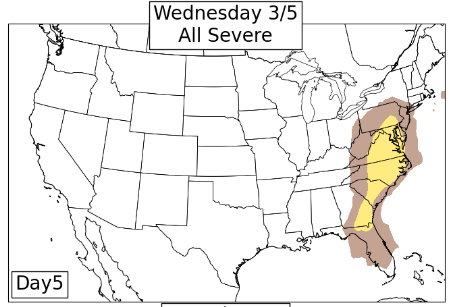
In all seriousness - I still continue to expect nothing more up here than gusty showers. It's worth noting, however, that some of the NSSL models (experimental?) bring better parameters into parts of the closer-in metro areas tomorrow in the 17z-20z timeframe. While I concur with SPC (of course) that the best threat is well south of us like SEVA and into NC...I've continually been saying that dynamic systems can surprise. The 1730z Day 2 Outlook from SPC even mentions "strong tornado" potential in the enhanced area! While nothing like that will be realized this far north - my eyes will be on subsequent 3km NAM runs and the HRRR even once it's more in range. For now, the NAM and NAM nest are a lot less enthused than some of the B-team models like the ARW and NSSL models. I haven't tracked the verification scores on those NSSL models either...so it could be that they all more or less follow the leader. Even the robust models quickly wind down the threat NE of the Potomac - but counties adjacent continue to be worth monitoring. The image I posted above if it were 70s-80s degrees and moist would scream "line of supercells" to me...but think things might be overdone on that.
- 1,378 replies
-
- 1
-
-
- severe
- thunderstorms
- (and 2 more)
-
Even if sub-severe this looks like good tracking practice for spring!
-
Actually...the ARW, ARW2, and HRDPS all have a similar line with similar northern extent. BRING ME MY GUSTY SHOWERS!
-
At least we've "got" the 0z FV3 lol

-
I thought it was marked operational now.
-
This *may* be a setup where we don't need ample dews with how dynamic the system is. It's rare (like you said) but we've certainly had a few Feb/Mar systems do some pretty impressive things. I like to think of our severe events as "balancing acts." Too little of any factor and yeah you will fail - but this is one of the times of year that lack of raw instability CAN be made up for with wind fields and such. Again - not saying that this will be the case - I'd put bets on this just being a gusty lines of showers with an embedded rumble of thunder...but stranger things have happened.
- 1,378 replies
-
- 1
-

-
- severe
- thunderstorms
- (and 2 more)
-
I mean probably Euro lol but I don't think it's as cut and dry as some times during winter storms. I will say - once timing is "locked in" - lines of storms and initiation tends to happen a bit earlier than modeled (even the day of)...this is why we sometimes get crapvection to kill anything later in the day - or the main line just comes through too early before we destabilize. Re: this threat specifically - I still agree with @high risk essentially. It's early in the season but we can certainly sneak a surprise here or there. I'm not expecting an "outbreak tier" event for our area...and honestly I have doubts the "better" instability makes it much further north than Richmond. If the GFS timing is closer to being right (faster), it will come through even during the late morning. The earlier runs I was referencing it was pretty stark...GFS with it during that timeframe and Euro waiting until a better time in the daylight cycle. Always a risk we remain wedged in this time of year. Only time will tell.
- 1,378 replies
-
- 1
-

-
- severe
- thunderstorms
- (and 2 more)
-
One thing to note - the GFS seems to be much faster than the Euro.
-
And here is the latest CSU MLP run - this is an increase from yesterday's run.
- 1,378 replies
-
- 3
-
-
- severe
- thunderstorms
- (and 2 more)
-
0z CIPS guidance had some beefy analogs. Doubt we meet some of those - but it's noteworthy if nothing else as to the dynamics of this system. 3/31/2022 4/13/2020 Those are both in the analogs.
- 1,378 replies
-
- 1
-
-
- severe
- thunderstorms
- (and 2 more)
-
CIPS and CSU-MLP both have some signs of life for that time period next week as well.
- 1,378 replies
-
- 2
-
-
- severe
- thunderstorms
- (and 2 more)
-
This time of year we are going to generally have to hope for a SUPER dynamic system. Pretty unlikely we'll have a ton of CAPE available...but it may not take much if the shear and storm system are dynamic enough on their own.
-
@WxWatcher007 - If you have a high res version or ever make one - I would honestly pay to have this turned into my blanket/comforter of choice.
-
I shouldn't speak too loudly though...I was going through old videos a few weeks ago and I found one where I am narrating snow falling out the front door and I say "WE HAVE SOME HEAVY SNOW FALLING HERE TODAY" and you can hear my mom in another room yell back "THAT'S NOT HEAVY." We're all weather weenies at heart that want heavy snow.