Kmlwx
-
Posts
13,594 -
Joined
-
Last visited
Content Type
Profiles
Blogs
Forums
American Weather
Media Demo
Store
Gallery
Everything posted by Kmlwx
-
The HRRR still brings some UH tracks near the DC metro area after 0z. We'll see...
- 1,378 replies
-
- 2
-

-
- severe
- thunderstorms
- (and 2 more)
-
Nah this time I'm legitimately being a deb. We likely are stuck at the Yoda-tier for the system.
-
I could also see a scenario where the stuff coming up through VA into the DC area now precludes any instability from really taking hold and stabilizing us before any later line. That seems pretty likely...
-
Gotta love my interesting weather reverse psychology.
- 1,378 replies
-
- 2
-

-
-
- severe
- thunderstorms
- (and 2 more)
-
HRRR (not saying it's right) has been showing that kind of lifting NE and not making a ton of progress into the metros. Latest run seems to show some backbuilding that might "get it done" but it could be sub-severe. To be honest - I thought this could end up being a beefier version of the event a week or two ago - but I now think this will be under that. We'll see how things lay out in the coming hours!
-
The more I see, the more I really believe the scenario where the OH/PA stuff goes mostly NW/N of many of us, and the other activity goes S/SE is actually what is going to happen. Obviously this is a very MBY(s) opinion. Perhaps the M/D line counties get clipped by the NW stuff and Southern Maryland and similar locales get the SE stuff...but I'm pretty lackluster right now on anything for DC/MoCo/PG/AACo and similar areas. Precipitation, sure - but severe I'm questioning whether I jinxed the local folks with the WxWatcher007 blanket.
-
Meh
-
Funny how weather works. All along I'd have thought if there was an upgrade it would be in the Carolinas.
-
11z HRRR = it sends a supercell or some intense line segment right through Northern Virginia and Central Maryland in the 19-20z timeframe.
- 1,378 replies
-
- 1
-
-
- severe
- thunderstorms
- (and 2 more)
-
21z SREF has continued the trend of pushing some better parameter trends towards us. Some of this, I guess could just be being closer to game-time and having members coverage. However, a look at the last 6 or so runs of the "Significant Tornado Ingredients" product shows a pretty clear trend. Of course, we are on the northern edge - but it really is honking hard it seems for an area from NC into parts of VA for a tornado threat. Again...it's the SREF but it does seem to sometimes at least be good to look at for where things are trending even if the run verbatim isn't accurate.
- 1,378 replies
-
- 1
-
-
- severe
- thunderstorms
- (and 2 more)
-
0z GFS had a system around the 25th that looked good for severe potentially. 6z seems much less favorable but it's worth watching.
-
The new day 3 SPC outlook trimmed the slight risk and sounds pretty meh lol
-
I tend to agree. Though as I mentioned above - the further we get into March/April/May the easier it is to get a better warm sector even if contaminated by rain. I still think it's awfully early - but this system synoptically may end up carrying some more "juice" versus that last one.
- 1,378 replies
-
- 1
-
-
- severe
- thunderstorms
- (and 2 more)
-
I, too was somewhat enthused at the 12z NAM nest. However, it's the NAM nest at range. For now - the WxWatcher system is seemingly at the Yoda tier.
- 1,378 replies
-
- 1
-
-
- severe
- thunderstorms
- (and 2 more)
-
The latest SREF graphics on the SPC site have improved from the prior runs. Will be interesting to see if it's just the event getting closer and outliers dropping away - or if it's an actual trend.
- 1,378 replies
-
- 2
-
-
- severe
- thunderstorms
- (and 2 more)
-
My thoughts are mostly unchanged so far. I think instability will be a major limiting factor. Euro is still more robust than the GFS in that department it seems (at least the 0z). I didn't look at the 6z Euro yet. Either way - it's probably going to rain and there will be gust pre-frontal winds regardless. I'm not total meh-ing yet but I'm not overly enthused up here. Though like I said for the last event - it's a dynamic system...surprises can happen. And the further we get from the winter season - the higher out chances get for more favorable thermo environment.
-
Still probably a bit too early in our "season." - I'll start paying more attention April 1.
-
LWX in their afternoon discussion is pretty meh on the threat due to meager instability. Can't say I disagree. Socked in with precipitation or clouds is really one of our top ways to fail.
-
The NCAR AI link above seems to be pretty robust for Sunday...FWIW. CSU MLP is less impressive - but the yellow area increased from the really meh runs a day or two ago.
- 1,378 replies
-
- 2
-
-
- severe
- thunderstorms
- (and 2 more)
-
The WxWatcher007 blanket might have worked! I added it to my bed last night. More data needed before we can be sure lol
- 1,378 replies
-
- 2
-
-

-
- severe
- thunderstorms
- (and 2 more)
-
Here - https://www2.mmm.ucar.edu/projects/ncar_ensemble/ainwp/?fbclid=IwZXh0bgNhZW0CMTAAAR3_KcoSRHWhY1lxCTCfOqSNC0AD8SUSmL_c7R_N8rtpvo-PsNNvuY3vuI4_aem_Stpgx3ntIqB8IVErFY76cQ
- 1,378 replies
-
- 3
-

-
- severe
- thunderstorms
- (and 2 more)
-
All downhill from here for all of us I'm prepared to accept my fate as forum severe-jinx if this blanket leads to the most dud Mid-Atlantic season ever.
- 1,378 replies
-
- 1
-
-
- severe
- thunderstorms
- (and 2 more)
-
I'm going to burrito myself inside of it whenever we have a short range severe weather threat. Maybe it will protect against being socked in by clouds/busts.
- 1,378 replies
-
- 3
-
-

-
- severe
- thunderstorms
- (and 2 more)
-
Re: the Sunday severe risk - timing is still shifting around quite a bit...but I could see it being similar to the other day...
-
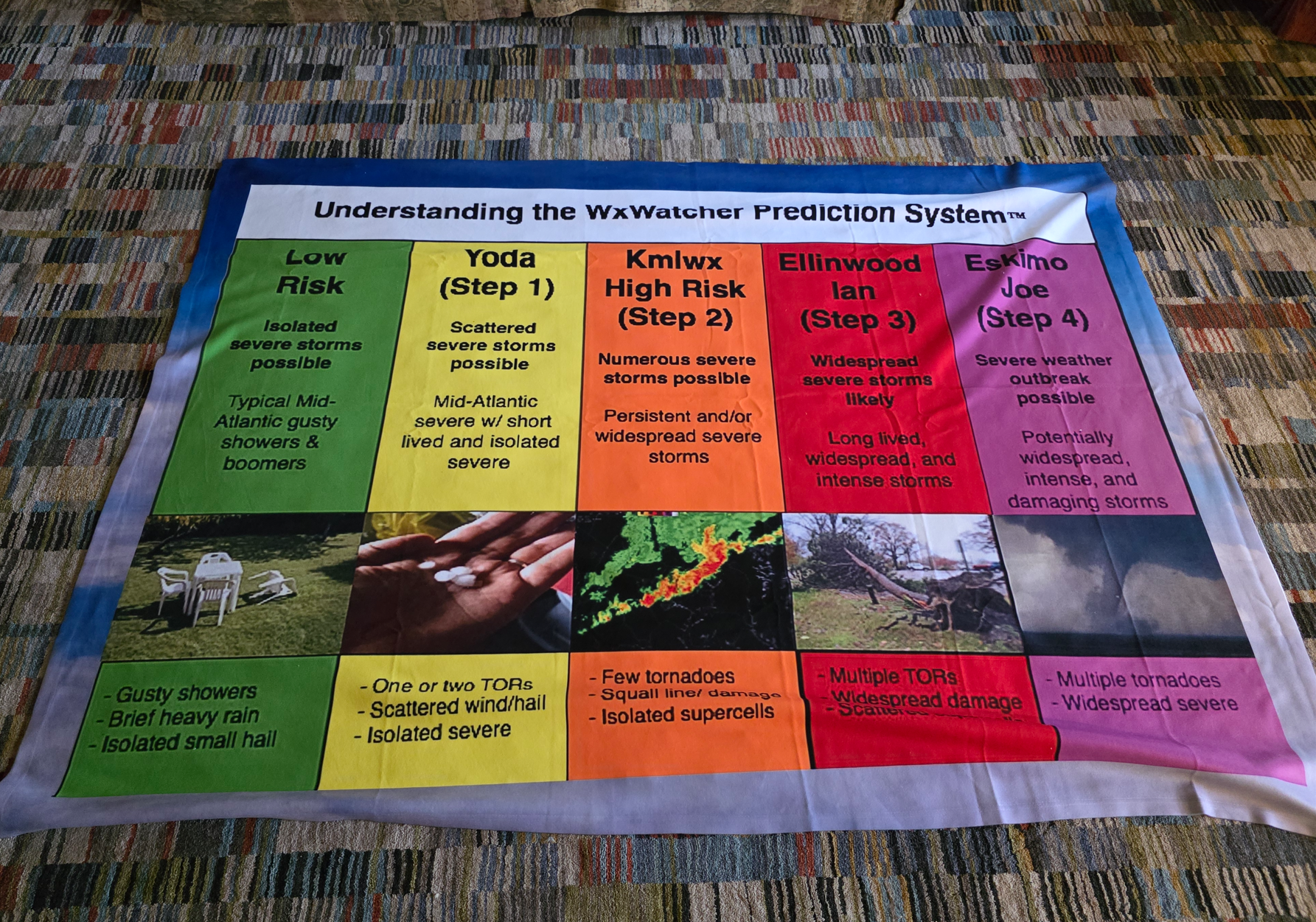
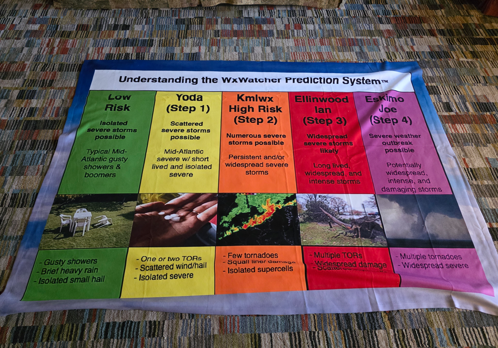
@WxWatcher007 - I was being SO serious when I said I wanted to turn it into a blanket. It arrived today. Well worth it.
- 1,378 replies
-
- 25
-
-
-
-

-
-

-

-
- severe
- thunderstorms
- (and 2 more)