

Kmlwx
-
Posts
12,808 -
Joined
-
Last visited
Content Type
Profiles
Blogs
Forums
American Weather
Media Demo
Store
Gallery
Posts posted by Kmlwx
-
-
-
8 minutes ago, yoda said:
@MN Transplant will probably be surprised by the HWW
Maybe not. Earlier it seemed more of the conservative guidance had beefed up winds. At a larger scale I doubt it will be prolonged HWW criteria winds...but that semi-convective element/line could bring down a brief period of winds meeting the criteria. The general background will still probably be 45-50mph gusts outside of that period. But with soggy ground, and to increase awareness, probably fine to go with the HWW.
-
7 minutes ago, WxUSAF said:
I got 3 evaluations for repairs to my gutters over the holidays. Would have been nice if 2 of the 3 could actually send price estimates so I could have had the repairs done before our 5th heavy rain event in the last month…
And of course as soon as you get the repairs done the Nino firehose will shut off and we'll go bone dry.
-
 1
1
-
-
Just now, MN Transplant said:
You are correct. The HRRR has definitely stepped up winds since yesterday.
Still probably safest to bet against 60mph winds inland away from the bay...but poking around the various models it does look like many of them now seem to "agree" on a swath of the higher end winds sweeping across the Central Maryland area...probably coinciding with that forced line later this afternoon/evening. Maybe we mix down a brief period of 60+ on a wider scale than expected. Otherwise, probably 40-50 tops still.
-
The 12z HRRR seems pretty robust on wind. Haven't followed the past few runs but I seem to recall it had much lower gusts than the outlandish models showing widespread 60+
ETA: RRFS is robust now as well. -
3 minutes ago, 09-10 analogy said:
Pity this isn’t May with a 75/68 spread
With wind that strong they'd probably rip apart the updrafts lol
-
1 minute ago, mattie g said:
www.tropicaltidbits.com
Viewing on mobile is alright - but it's a lot easier when images load directly in the thread.
-
2
-
-
22 minutes ago, Eskimo Joe said:
Our soils are quite saturated and it doesn't take much during the winter for flooding to develop. Cold ground and no vegetation means runoff can't be absorbed as efficiently.
This. There's a difference between being concerned about 70mph winds and being concerned about wind damage. Classic setup to have a good bit of damage reports even if the wind is relatively tame compared to our biggest gust events.
For "ground truth" there's often not a ton of difference from a 45mph wind event with saturated soil versus a 60+mph event in normal soil conditions.
Sometimes people forget that just because the criteria isn't met for a HWW that it won't still be high impact.
Compare it to a few hundredths of an inch ice accumulation impacting roads same if not more than a 5+ inch snow event.
-
21 minutes ago, dailylurker said:
When the trees are bare they can easily handle even wind gust to 60, even with wet ground. Wind gust to 45 are pretty common and would be boring and uneventful lol
Problem is that some trees come down if a person farts. PEPCO/BGE/Dominion will find a way to stack outages up I'm sure.
-
3
-
-
Yes - there's probably going to be widespread 45mph gusts - but it's not going to be the crazy gusts a few models runs have printed out. Unless you're in a favored spot for wind, it will likely be an advisory level event. However, with potentially soggy ground and such - I'd be more trees than usual come down.
-
2
-
-
It would be awesome to have some remaining snow cover to keep things cooler ahead of the Tuesday storm. Now we root for a colder trend for more of a front end thump!
-
 1
1
-
-
3 minutes ago, nw baltimore wx said:
I just zoomed in to the roof of my house and it's 508'.
")
Let's get together and build a 5000ft tower for snow obs. We can take slant stick measurements from the top for our official obs.
-
 1
1
-
-
For those of you that want to nailbite even more about elevation - this is the Maryland LiDAR viewer
https://geodata.md.gov/topoviewer/
Cool tool if nothing else - REALLY high-res data there. I think @mappy might have been the one to post it a long while ago. For map geeks, can get lost for hours in just scrolling around.
-
3
-
 2
2
-
-
Razor thin line for the fall line - but in this type of setup just have to accept it. Will be a nail biter for the folks riding that line - but suspect this is going to be a "classic" elevation winner storm of the past. I sure as heck won't jackpot in the eastern half of Montgomery County - but I'm okay with where I sit...for now. If it bleeds N/W again I'll be screwed.
What a terrible hobby for us to all have")
-
5
-
-
Just now, RDM said:
NWS posted a large swath of notices from Fredericksburg South for Hazardous Weather Outlook for Fri night/Sat. Somewhat odd - nothing N of that.
That's a different WFO
-
Just now, Eskimo Joe said:
06z EPS doesn't go past 90 hrs. Here's the 00z EPS for you:
I thought the OP went to 90 but the EPS went out farther at the off-hour runs. Maybe I'm wrong!
-
17 minutes ago, Terpeast said:
IAD got 10” with that Jan 1964 storm
Mood in this thread seems a little better now. I was afraid to open it this morning!
The mood in here can swing hourly (or even less!). We weather geeks are a really weird bunch. If only more of us could take the @Bob Chillmentality.
-
4
-
2
-
-
18 minutes ago, BristowWx said:
I can’t believe that 192 panel on GFS is showing rain with those rates inside the 534 line. That should show us getting clocked even though it’s fantasy range.
Even at fantasy range - a low in that position is not going to be good for most of us

-
2
-
-
I usually lurk in the long range threads - and what I am about to say is purely "gut feeling-esque" but this upcoming period while it may not be the "peak climo" or "best odds" - has the feeling of a period of time that might define the remainder of winter. In other words, if we can find a way to make snow work with a less than perfect pattern a time or two in the next 2+ weeks, it feels like something bigger might come "easier" (term used loosely). Similar to how Bob and others say some winter it just "wants to snow"
If we get skunked through like January 10th, it may still be game on for later in the month and into Feb, but it'll have a whole different feel if we can back into or have a few events sneak in before primetime.
-
8
-
-
2 minutes ago, Ji said:
im only here with PSU for HECS. after all these years..i dont think even MECS would do it
If they came over a short enough period with sustained cold it could be a "cumulative HECS" lol.
-
3
-
1
-
-
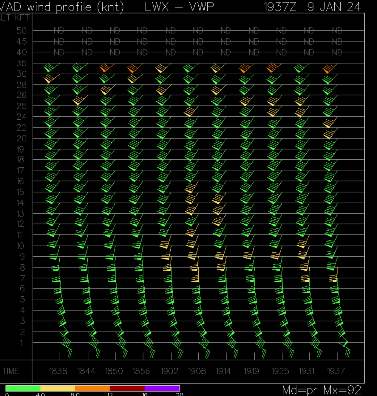
The 6z NAM has a short period of like 90kt+ winds in the area at the 850mb level. Doesn't seem any of the other guidance has it this high at all.
-
Just drove from Odenton over to Colesville. Rain 100% to start the trek and then raindrops on the windshield started to take on a mangled flake consistency. By the time I was on the ICC (MD-200) near New Hampshire Ave it was seemingly mostly/all snow and coming down nicely.
-
1
-
-
5 minutes ago, psuhoffman said:
I know this is lols but I wouldn’t be shocked if places closer to the cities get 1-3” of one of these bands the meso models keep hinting at actually sets up.
Interesting that it's been repeatedly showing up right along the fall line for the most part.
-
Thunder just now in the Odenton area in Maryland.
-
1
-
Tuesday, January 9 Rain and Wind Storm
in Mid Atlantic
Posted
Starting to hear the wind roaring up in the top levels of the trees. Nice movement of the trees too. Going to be a lot of tree down calls coming in throughout the evening. Stay safe!