

Kmlwx
-
Posts
13,020 -
Joined
-
Last visited
Content Type
Profiles
Blogs
Forums
American Weather
Media Demo
Store
Gallery
Everything posted by Kmlwx
-
Question will become whether it will maintain strength as it crosses the boundary into the more stable airmass north of the front.
-
This is extremely lame so far.
-
Tstm watch for areas west of the metro area.
-
The warned cell is exhibiting some supcellular qualities
-
Appears to be a boundary just south of the Potomac running across DC and then into Maryland. Visible nicely on satellite and even a bit on radar too.
-
15z HRRR keeps everything north and west of the cities. Doesn't get much at all into the metro corridor.
-
Definitely looks like a little "tongue" of clearing is working it's way into central MoCo.
-
Delmarva starting to erode the wedge but no such luck in the DC/Balt area.
-
Making a little progress - looks like DCA is out of the wedge and maybe even the southern parts of MoCo.
-
I tend to just use them to get an idea of where the "best" activity might be - and also to look for consistency. Other than that I don't really think they have much use. I've seen days where they look crazy and we get nothing as well as days where just a little green shows up and we get multiple TORs
- 2,802 replies
-
- 1
-

-
- severe
- thunderstorms
- (and 4 more)
-
10z run of UD helicity swath map
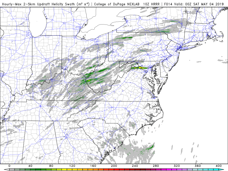
-
The stupid UD helicity swath map
-
Example from the 11z run - using the COD site - https://weather.cod.edu/forecast/
- 2,802 replies
-
- 1
-
-
- severe
- thunderstorms
- (and 4 more)
-
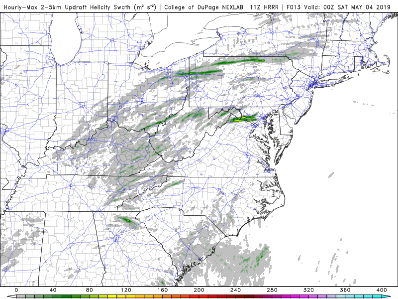
Consistency at least - of course it could be consistently wrong... But 11z HRRR has almost the same thing.
-
10z HRRR sends a legit looking supercell over Central Maryland this PM
-
Are we looking at the same NAM? I don't see much of anything to get excited about on the NAM (18z OR 00z)
-
Tomorrow's threat appears to now be focused NW of the area by the longer range HRRR and the 3km NAM
-
Long range 12z HRRR (lol) has a streak of very nice UD helicity across the area tomorrow PM. Both today and tomorrow look good on simradar
- 2,802 replies
-
- 2
-
-
- severe
- thunderstorms
- (and 4 more)
-
Days and days and days of MRGL
-
To be honest- hearing my friends (non weather enthusiasts) and coworkers - most people still do not understand which is worse (watch vs warning). A lot of this is ignorance - watches don't trigger CMAS so it should be fairly obvious to the public that "TAKE SHELTER IMMEDIATELY" is more serious than "CONDITIONS ARE FAVORABLE"
- 2,802 replies
-
- 1
-
-
- severe
- thunderstorms
- (and 4 more)
-
The latest (11z) HRRR has essentially nothing
-
I'm right around 270 and Montrose - evil looking clouds but no tornado of course. Then heavy rain.
-
And he's back
-
You seem awfully bullish. Who are you?
- 2,802 replies
-
- 1
-

-
- severe
- thunderstorms
- (and 4 more)
-
That frontal analysis on the meso discussion map indicates warmfront nearby. That will definitely enhance tornado risk.
