

Kmlwx
-
Posts
13,021 -
Joined
-
Last visited
Content Type
Profiles
Blogs
Forums
American Weather
Media Demo
Store
Gallery
Everything posted by Kmlwx
-
Yeah 06z NAM nest has the parameters still but does the DC/Baltimore split it seems. Lame.
-
Comical...I picked a sounding in our area from the NAM nest at 22z on Thursday and it has a SARS match from DDC (95052300.DDC) with a 6in hail result. Still a TON of hail results showing up from SARS...interestingly enough - there have been some IAD ones showing up in the matches. FWIW (not much at this range) the sim reflectivity on the 3km NAM doesn't look all that impressive. I'm half in and half out.
-
I was pretty meh on it except for just keeping an eye on it up until today. Enough consistently good SARS returns and such to at least keep my eye on it. And having @high risk be interested is enough for me to stay partially in. If nothing else - the one big thing you always rightfully say is lacking (lapse rates) might be better this go around. I think the biggest "meh" right now is that it looks focused to our north. I'd feel pretty good if I was along a line running from like Pittsburgh to @mappy perhaps. Though I think the risk is there for some places to get a really nice cell or two. I think odds are pretty good of one of those days where one or two cells put down really large hail in isolated spots but the area at large doesn't see a widespread event. There are a few example of perhaps what could transpire in the Washington Weather Book IIRC - I loved that book in grade school.
-
Posted for those who don't want to go digging for it -
- 2,802 replies
-
- 8
-

-

-

-
- severe
- thunderstorms
- (and 4 more)
-
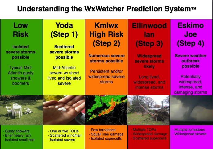
@high risk I suspect if @Eskimo Joe pops in here he might be more enthusiastic than he normally would be. He's generally pretty down on lapse rates in our parts unless we get an EML or something to advect in. Obviously he might find a reason to deb...but he'll be an interesting "weather vane" - let's crack out the WW007 severe weather scale!
- 2,802 replies
-
- 1
-
-
- severe
- thunderstorms
- (and 4 more)
-
Posting the SREF at range below - not for the specific map type - but because it outlines the best risk area really well (and as such the area outlined in SLGT right now for D3).
- 2,802 replies
-
- 2
-
-
- severe
- thunderstorms
- (and 4 more)
-
I'll be honest - I'm not sure since SARS became publicly visible I've seen so many consistent model runs (even if it's the NAM out in time a bit) - return so many results. I'm used to it showing a bunch of "loose matches" but not many actual results in the boxes. There are a few soundings on the NAM in our area that have so many results they go out of the box for Thursday. Like @high risk has said - I think the main threat is north of the area. This might be a case where north of the Potomac stands the best changes. Will be interesting to watch model trends as we get closer and closer. Risk is there it seems for some big hailers (which except for isolated cases isn't super common around our area). I've seen a few soundings with interesting looking hodos too.
-
18z NAM nest has lost the earlier cells for Thursday and instead brings a squall line through parts of the area around 0z. Favors north parts of the area too.
-
CIPS at the 60hr mark on the 12z run has some robust events showing up in the analogs. 5/14/2010 - which appears to have been a big day for hail around the area. 6/24/1996 which had some local tornadoes among the other reports. 6/23/2015 - which had wind damage in the area.
- 2,802 replies
-
- 1
-
-
- severe
- thunderstorms
- (and 4 more)
-
There's even been some SARS matches of 4.5in hail - Hail is one of those harder things to come by around these parts. Every now and then a swath will get absolutely plastered. Time will tell for Thursday!
- 2,802 replies
-
- 1
-
-
- severe
- thunderstorms
- (and 4 more)
-
SARS is also still kicking back a lot of large hail matches on some runs.
-
Yeah - it definitely seems like north is the better location for storms - and this is reflected in the slight risk area from SPC.
-
Slight risk for Thursday for northern parts of the area. Then we have a 15% extended outlook nearby for day 5 (not yet in our area). Looks like LWX is pretty bearish on the weekend. SARS continues to print out some hefty analogs for Thursday, though. Some big hail showing up. We'll see how it pans out.
-
SARS has been showing some sig hail matches for Thursday PM. Too far out to say anything at this point - but between CIPS and the models generally suggesting a severe weather threat - it bears watching. I'm hardly watching our area for today - all eyes are on the plains.
-
Thursday looks like our next good potential for something organized.
-
Thursday continues to look interesting on CIPS and GFS.
-
0z output from CIPS is not bad looking for our area at the 120hr period.
-
I was in Calverton earlier and the lightning off in the distance looked spectacular.
-
Sunday doesn't look that impressive anymore locally. But we are close to a slight from SPC. We'll see. Meanwhile - looks like Ian and our guys are in for a nice chasecation!
-
We need to change that lol into a woo
- 2,802 replies
-
- 1
-
-
- severe
- thunderstorms
- (and 4 more)
-
I'm punting today. Looks ho hum around here...and for most of the area. Sunday on the NAM really looks interesting. We'll see if it holds as we get closer. Nice instability of over 3000 on some of the soundings nearby. Good helicity too. And the LOL UD helicity maps on the end of the 3km run are nice looking.
-
Sunday afternoon/evening looks like it has potential on the 3km NAM.
-
Slight risk for today.
-
Looking at LWX velocity scans I'm not sure i see much other than the abrupt windshift.
-
That storm is going bonkers right now...
