

Kmlwx
-
Posts
13,022 -
Joined
-
Last visited
Content Type
Profiles
Blogs
Forums
American Weather
Media Demo
Store
Gallery
Everything posted by Kmlwx
-
What do you mean? Like radar site? I'd use KLWX and the local tdwr locations at the airports. If you mean app - Radarscope for mobile devices and GR (all products) grlevelx.com
-
HRRR's when the line was starting to form didn't even have it.
-
WIsh we had monster shear.
- 2,802 replies
-
- 1
-

-
- severe
- thunderstorms
- (and 4 more)
-
Storm near CHO is going big time.
-
Somebody didn't calibrate.
-
Now we just need a heat clearing derecho at the end of this horrid stretch.
-
Tree down on house in Forest Glen
-
Nice wind core with the warned storm
-
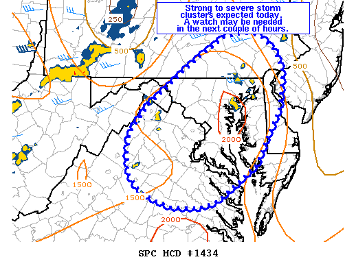
https://www.spc.noaa.gov/products/md/md1434.html
-
Mesoscale Discussion 1434 NWS Storm Prediction Center Norman OK 1151 AM CDT Thu Jul 11 2019 Areas affected...northern VA...MD...DE and southeast PA Concerning...Severe potential...Watch possible Valid 111651Z - 111815Z Probability of Watch Issuance...40 percent SUMMARY...Thunderstorms will increase in coverage and intensity this afternoon. A few damaging gusts are possible and trends are being monitored for possible watch issuance. DISCUSSION...Widely scattered thunderstorms are beginning to develop over the higher terrain of central and northern VA into southeast PA. Cloud cover across this area has not been as much of a hindrance compared to areas to the north, and temperatures have warmed into the mid 80s to low 90s F with dewpoints in the low to mid 70s F. Midlevel lapse rates are rather poor, but this warm and very moist airmass is resulting in MLCAPE values of 1500-2000 J/kg. This area lies on the southern periphery of modest effective shear of 20-30 kt, with high PW values approaching 2 inches. Upper forcing for ascent will modestly increase as the upper shortwave trough shifts eastward toward the lower Great Lakes and central Appalachians later this afternoon, but overall severity/organization will be limited somewhat in the absence of steep midlevel lapse rates and strong deep layer flow. Nevertheless, some forward propagating clusters will be possible through storm and outflow interactions, which could result in a few strong/severe gusts through the afternoon. Convective trends will be monitored and a watch may become necessary in the next few hours. ..Leitman/Grams.. 07/11/2019 ...Please see www.spc.noaa.gov for graphic product... ATTN...WFO...PHI...AKQ...CTP...LWX...
-
Surprised there's not a pity meso yet with all the pop up general showers and storms around.
-
Should be a bit faster moving so that might be one thing that prevents massive flooding. Reflectivity on some of the model output looks good - but yeah seems like an isolated day for actual severe.
-
Calm down you two.
-
Wasn't speaking for location specifics - more the fact that each time I've looked at them this year they've shown like tiny little cells or nothing at all for most of our events.
-
https://www.tropicaltidbits.com/analysis/models/?model=wrf-arw®ion=us&pkg=mslp_pcpn_frzn&runtime=2019071012&fh=6 one of 'em
-
Just peaked at them over on the TropicalTidbits site. Only had time to give them a quick glance. Work is blech today.
-
Some of the CAMs like the ARW/ARW2/NMM - which have looked pretty weak sauce for prior events this year - look QUITE robust for the region tomorrow.
-
Marginally I guess for now. I don't think it'll be an outbreak. Probably just higher than 50/50 odds of any location getting a boomer.
-
The long range HRRR from 12z is VERY good for our area for tomorrow.
-
Slight risk posted for tomorrow.
-
Thank goodness this cluster is moving a bit - I remember in June 2006 it would just keep training. The rates are crazy this morning.
-
That was not fun to drive through. I was heading west from Colesville to Potomac/Rockville. Tons of standing water.
-
There was some talk of a potential ring of fire pattern in the long range. I haven't looked at it too much - have been busy.
- 2,802 replies
-
- 2
-
-
- severe
- thunderstorms
- (and 4 more)
-
I didn't say they did... Look at the radar - it's not unrealistic to say that it's possible for Ellicott City to get stuck under training storms or stationary storms. A few hours of that would easily cause major flooding issues for them.
-
Ellicott City has to be nervous on a day like today.

