

Kmlwx
-
Posts
13,026 -
Joined
-
Last visited
Content Type
Profiles
Blogs
Forums
American Weather
Media Demo
Store
Gallery
Everything posted by Kmlwx
-
Payback for a TOR "outbreak" a few weeks ago lol. I'm getting bored without anything substantial to track.
-
@yoda - don't know if I'd refer to that as "gungho" seems more like they are just saying IF there was an area that had a higher risk - it would be there. The background risk is pretty low still. They just do a great job it seems of fleshing out the discussion and describing the potential.
-
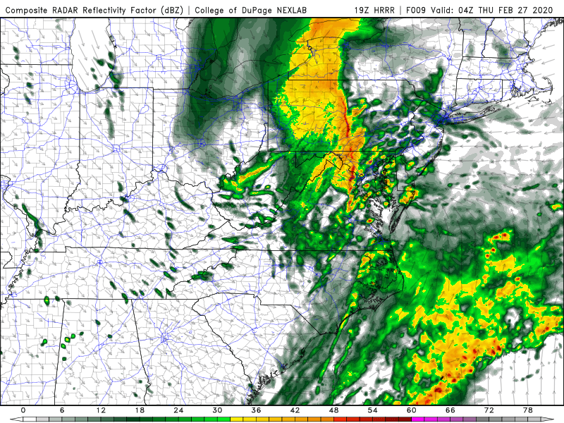
19z HRRR at 04z this evening. Looks acceptable.
-
Different timing too - though some might argue the timing was even worse for that one. Wasn't it during the morning rush? I remember I was stuck in it driving to work around 7:45 that morning. I guess timing doesn't really mean crap in these low CAPE cold season events.
-
https://www.spc.noaa.gov/products/md/md0131.html Just posted to Twitter - but it's not up on SPC quite yet.
-
That's about the max potential on this one. Absolute max. My current thinking (not very bold) is for zero TOR reports in the LWX CWA this evening and fewer than 5 reports of wind damage. I'm sure LWX will throw up a few warnings. I'll go max measured gust of 53mph.
-
The latest HRRR looks a bit better. Nothing significant but just a more solid line and a bit more on the gusty wind side of things. The weenie in me also sees a tiny bit of that light green shade on the UH maps.
-
16z HRRR had a bit more of a consolidated line.
-
Then again - it's the HRRR and could be totally wrong - but with agreement maybe not.
-
HRRR continues to send the most continuous part of the line mostly to the north of Central Maryland. It's more broken in DC proper and very scattered south.
-
Awesome visible satellite this morning https://i.imgur.com/yJLUNWt.mp4
-
Wish we could muster dynamics like today with sunny skies in May.
-
LWX did note yesterday that it might come in a bit faster than expected with how dynamic it is. I can barely make it past 9:30pm myself these days.
-
The high risk better be squarely centered around my place of residence.
-
I don't believe there has been a high risk anywhere in the northeast since 1998.
-
@Eskimo Joe, @yoda, @high risk - @George BM is calling for SPC to issue a HIGH RISK for somewhere in the Mid-Atlantic or Northeast
-
Destined to flip at some point. Likely just in time for spring. April is bound to be rainy and raw.
-
The low pressure on the Euro doesn't pass as close to us as the event a few weeks ago. But the H5 chart is ripe looking.
-
It looks really nice. I wish CIPS Analogs ran on the Euro...would be interested to see what that spit out. 132 hours away isn't even that far...
-
I'm about to look...if I am not blown away I will be disappointed.
-
Severe Wx is a much higher probability event type to track around here vs tropical.
-
Unfortunately - at least based on this - it's not doing much for the ice so far. https://nsidc.org/arcticseaicenews/charctic-interactive-sea-ice-graph/
-
Not even speaking about snow - but the weather in general just looks incredibly boring. Had it not been for that surprise TOR/severe day this would have been an exceedingly boring stretch...unless you like tracking steady rain. If we can't score with winter weather...I hope spring brings some excitement at least.
-
Why did NWS set the default radar view when you click the radar on the website to be composite? It's misleading IMO. It used to default to base reflectivity.
-
I want a deep freeze to cut down on the annoying bugs in spring and summer. I bet we have a huge mosquito season if not.


