

Kmlwx
-
Posts
13,026 -
Joined
-
Last visited
Content Type
Profiles
Blogs
Forums
American Weather
Media Demo
Store
Gallery
Everything posted by Kmlwx
-
It seems to be varying by location as well. I've had perfectly fine luck finding pasta, but yeah, TP is gone everywhere and seemingly is not being restocked. Meat has been decent at the places I've been too. I guess time of day matters too.
-
Don't believe anything is going to be in the cards for MBY this evening. On to the next event up here!
-
Temps are really heading upward. IF (big if) anything pops, it could get pretty good looking. Watching and waiting.
-
Sun coming out in Colesville/White Oak area. Kinda warm actually when you're in the sun.
-
Think we'd need a stronger S wind to scour out the wedge. Lots of full sunshine just outside the wedge, though. I could see somebody in western Maryland or the WV panhandle getting a decent cell this afternoon.
-
https://i.imgur.com/Xe0VYkb.mp4
-
Wundermap shows the front pretty clearly. The wedge is very visible. There's a station reading 84 out near Petersburg (can't be right...) but low to mid 70s in that area, 60s and 70s down south of Fredericksburg. Looks like the wedge is running roughly from areas like Hancock, MD south to Winchester and then to Culpeper, over to the Potomac River etc.
-
Finally back at a computer - have been driving back from PA, to the apartment in Columbia and now at my parent's place down in Colesville. Super foggy for this far into the day. About to pull up surface obs to take a look where it is.
-
The front isn't here for sure. Sitting around 50 in Columbia and socked in with clouds and fog
-
That is high praise coming from a tagged met! Thank you! I like to think I've come from one of the biggest weenies here in 2006 (from the Eastern days) to where I am now thanks for folks like you. Tomorrow could be really nice for an isolated swath of real estate that gets under a cell. Just not sure there will be more than one or two of them total.
-
The 0z 3km NAM appears (based on 2m temps) to get the wedge hung up a bit. In late March, I would be inclined to believe the wedge will be harder to erode than easier. The diving line is about the Potomac River on that run. Some high parameters in a pocket down near La Plata, Fredericksburg etc. That's a very believable scenario for now. If I was looking for severe, I'd rather be down in that area than in my area or certainly not @mappy 's area. Though we all know that playing with boundaries and fronts can be rewarding due to the shear. It's going to be a day of low coverage it seems - but if one cell can get rooted and has surface based instability to work with - that discussion is well within the realm of possibilities. Certainly not a widespread svr day.
-
15 and 21z SREF runs both placed the bullseye (nothing too high) of tor ingredients right over the DC metro tomorrow afternoon.
-
Just had a chance to sit down and look at some of the guidance. ARW, ARW2 and NMM pretty much show nothing for us tomorrow. HRDRPS has some nice looking activity in the 20z time frame...but not sure I'd want to put all my eggs in the HRDRPS. We'll probably be stuck with a game time call.
-
Looking at the 18z long range HRRR and the latest 3km NAM - I'm pretty torn. They don't really have much activity in the area - but they do hint at the possibility for one or two good cells. Seems like our usual type of event where it could be an absolute nothing-event. But that SPC and LWX discussions definitely are conditionally very intriguing. A few days ago I had this pretty much written off. Will come down to our typical question of instability. Would be a lot of fun to track something given how downtrodden a lot of folks are right now with the COVID-19 outbreak.
-
I've been on COVID monitoring for days/weeks now. This one kind of crept up on me...
-
Tambora, Toba, Long Valley, Yellowstone, St. Helens, Pinatubo all in one afternoon.
-
We are probably going to need a massive near-equator volcanic eruption to get us some good winter
-
Part of that is also what you've adapted to. 70 degrees with a dew in the upper 50s can feel awesome in fall but humid in spring.
-
Areas that have been in the clearing for the longest have warmed into the mid 60s.
-
There's a large area of clearing encroaching a big chunk of the area.
-
Line of clearing skies running between Lexington, Charlottesville and Culpeper. Another little patch of slight clearing up near HGR.
-
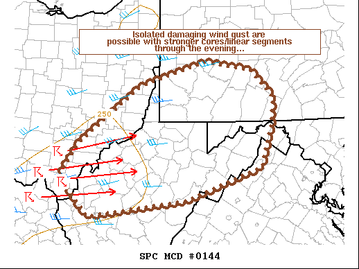
https://www.spc.noaa.gov/products/md/md0144.html
-
That is a very impressive sim radar. NAM doesn't look anything like it.
-
The parameters in some regards look better than the other day even. Simulated reflectivity on the longgggg range HRRR from the 12z run looks really nice.
-
Someone is a little cranky today eh? psu is one of the most respected posters in our subforum and even the entire forum at-large. Nobody scores a 100% in the world of weather. You seem awfully inflammatory...
- 820 replies
-
- 10
-

-


