

Kmlwx
-
Posts
13,024 -
Joined
-
Last visited
Content Type
Profiles
Blogs
Forums
American Weather
Media Demo
Store
Gallery
Everything posted by Kmlwx
-
High winds seem like they will be with the activity and in the morning.
-
You would track that line by the centimeter if you could
-
The 15z RAP has over 2000J/kg of SBCAPE through a good chunk of the area around surrounding the 17z timeframe. 1km EHI approaching 4.5 in a pocket...SigTor 8-10 in a chunk of the area. Dang...
-
Always glad to have your insight in our region. I would tend to think any hatching remains south of our area...at least with regards to TORs. I could see a hatched wind area come up to our area - especially if LWX is leaning more on the SVR TOR products to emphasize the wind threat rather than the wind advisory products.
-
Updated LWX disco snippet is dead on what I thought earlier .NEAR TERM /UNTIL 6 PM THIS EVENING/... Really not much to add to the previous discussion. High impact storm to affect the region Mon with significant risk of severe thunderstorms including tornadoes. Planning to issue a Wind Advisory for everywhere not included in a High Wind Watch. While widespread damaging winds are certainly possible in a lot of areas, these should be brief in nature and mainly convectively driven. Believe those will be handled better with SVRs or TORs as needed. Flooding rain threat seems to be diminishing and not planning issuing any Flood Watches at this time.
-
12z NAM (12km) has less CAPE into Southern PA. But still looks excellent for the DC area.
-
Going to be interesting to see what the 3km NAM spits out. GFS will bring us back to reality as usual. But interesting to see the models maxing out with time...
-
Long range 12z HRRR also going kinda bonkers...
-
If you took that RAP run at face value - it would seem to indicate we have just as much potential as some places in the Carolinas. I don't buy it. But the models continue to spit out some very healthy solutions for our area.
-
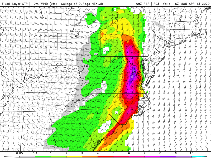
LOL at the RAP on the 09z run
-
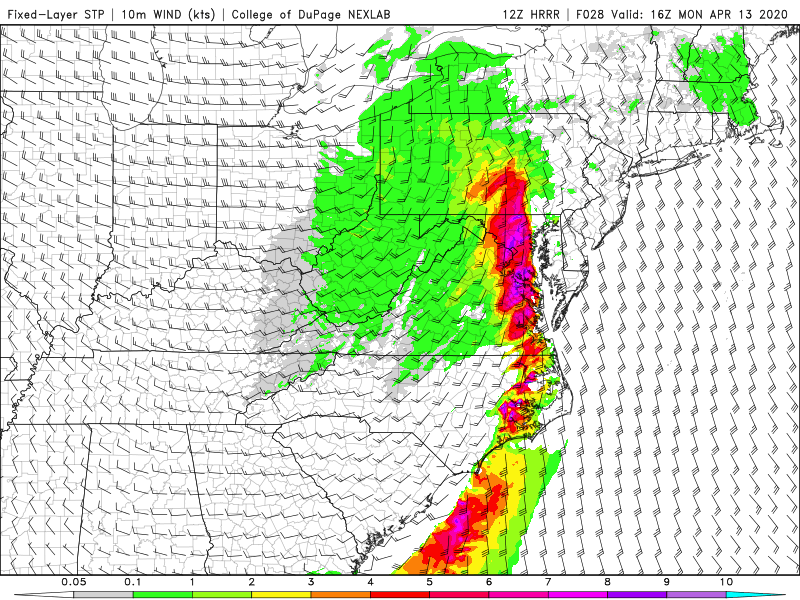
Not sure how useful the RAP is anymore - but at range it has 80-90kts at the 850mb level at 15z tomorrow.
-
Have to say - the big gap in the high wind watch products from WFOs to the west of LWX and WFOs east of LWX doesn't look great. Don't see a ton of harm going with a WATCH and ultimately going with an advisory if the higher wind progs don't end up verifying. But the whole purpose of a watch is for this reason. Could easily see gusts to the 58mph criteria. I wonder if their plan is to go with an advisory and then cover any HWW criteria winds with SVRs
-
Out of my subforum - but just an FYI - looks like there was an error. The outlook was amended about 1hr after being issued. Larger extent to risk area in your region.
-
WRF-NSSL run looks very robust for our area. Link below - several models on this page, in fact. https://cams.nssl.noaa.gov/?model=wrf_nssl_3km&rd=20200412&rt=0000&product=sbcape§or=spc_ma&postage_stamp=false
-
Huh? Entire area is under a slight risk with ENH not far away. Outlook was amended about 1 hour after issuance.
-
0z HREF has ensemble mean 850mb winds of 75 knots around the area on Mon.
-
LWX in their AM discussion was indicating only wind advisories for most of the area. HWW confined to ridge tops. NAM (06z) still has crazy winds at the 850 and 925 levels. NAM nest has surface wind gusts to 65mph almost area wide.
-
They amended the D2. Weird
-
Some of our big severe days do seem to have a morning round. But this is a lot. I wonder if it'll get some clarity and focus more on one of the rounds in future runs. IF the models still look like this at 12z tomorrow I'm going to really start honking. @Eskimo Joe - you're looking at 0z tomorrow night, right?
-
We would probably do just fine even with 1000 CAPE. We've had days of 500-750 do fine with high shear.
-
Some of these forecast soundings are edging closer to 2000 SBCAPE...
-
This run is pretty bonkers...Decent amount of SIG TOR results coming back in the SARS box too. That CAPE has gotta be overdone you'd think.
-
Posts tell the whole story. Big day tomorrow in the southeast. Maybe a decent severe day for us Monday. We'll see!
-
Yoda...the 0z NAM runs at like 10pm. That's not that wild I'll catch the new D2 tomorrow morning. I jinx things when I stay up.
-
Holy cow - GFS has a pocket of 68kt winds at 925mb around 15z Monday. 70-75 isn't far away either. Pockets of 80-85kts at the 850 level. Offshore of NJ at 18z Monday - the 850 winds are like 110kts on the GFS.


