

ORH_wxman
-
Posts
90,892 -
Joined
-
Last visited
Content Type
Profiles
Blogs
Forums
American Weather
Media Demo
Store
Gallery
Everything posted by ORH_wxman
-
Yeah the snow is screeching to a halt about 10 miles SW of me. Prob won’t get anything here.
-
It’s like 34F rain. We stay N of the sfc boundary but the midlevels eventually warm too much.
-
The funny thing is I'll finish slightly AN for January snow if nothing else falls. December was an epic turd, but January hasn't been terrible. Hopefully we can cash in next week on a lucky SWFE. Early February also doesn't look bad, but the issue is the favorable pattern could be transient even if it does occur.
-
Giant GOA low in the extended is a classic Super Nino signal....we haven't had it all season, but if it sets up and stays there, then you can probably punt February if there's no blocking. That said, I have no confidence in any pattern staying put for long since it hasn't really done that all since Xmas.
-
No it's not safe to say that.
-
The SWFE signal is def growing on the ensembles too for next Tuesday night/Wednesday. If that doesn’t crap out in the next couple of cycles, it’s probably going to be a legit multi-hazard event.
-
We got spoiled for years with those highs in Quebec…those La Niña seasons where we were getting several warning events on SWFEs while south and west furnaced. Hopefully we can grab in next week because it’s even a while as you said. These aren’t some obscenely rare feature…they do happen semi-frequently, but it was like pulling teeth the last couple seasons to get one.
-
Yeah we haven’t had a winter (or even a weeks-long pattern) in a while where we kind of sit in a more favorable spot than the middle and western part of the country. We’ve frequently been the worst.
-
About time we do that anyway. Been enough seasons recently where it’s cold out in the plains and Rockies while we furnace.
-
Tomorrow is gonna be a Virga tease. SW CT looks the best for any accumulations.
-
Low level dry air is a major problem on the Friday setup. If we had less dry air, it prob wouldn’t be that hard to get a fluffy 2-5” event for a lot of the area but it’s gonna be tough to saturate. South coast looks the best right now for obvious reasons.
-
He won’t be using the 18z GFS OP run beyond 300h…that’s for sure. Maybe he will post the 00z run if it shows a torch pattern.
-
The SST argument is always really bizarre to me…esp in January. It has very little to do with the longwave pattern. It maybe cost the coastline a bit more snow in the 1/7 event but we’re talking on the margins. The SSTs offshore could’ve been 3C colder and December still would’ve been an abomination.
-
Yeah that was kind of funny. GFS is prob 1-2” pike region with maybe a little more south coast. Pretty similar to the BOX map. They might be a bit heavier on the cape than GFS.
-
Scooter is teetering like it’s early January 2013
-
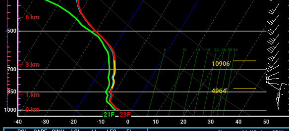
Yeah we're not getting that mid-level WAA that we like to see for healthy lift. Notice how the 850 winds are still light out of the northwest. We'd like to see that turn more southerly. You can also see a bit of dry air there below about 700-750mb. Thats going to be an issue for sure in trying to get decent QPF into SNE. It's fighting that very dry air funneling down from the north
-
That was right near my 'hood on the NAM. You can see it's fighting some dry air though even in that sounding. IF the dry column can be overcome, there could be a pretty nice stripe of snowfall given the deep DGZ and cold sfc temps....very high ratios most likely unless the lift stays too high above the DGZ....but usually when the DGZ is that deep, you're getting pretty good growth regardless...as long as there's some half-decent omega in there.
-
Check out how deep this DGZ is on the 60 hour NAM sounding...that's the type of temp profile where you can get 6" on 0.25" of QPF if you can squeeze that much out of the atmosphere.
-
NAM is more amped at 12z....but still fighting the dry air. If we're able to overcome the low level dry air then there could be several inches of fluff because the sounding have the snow growth zone like 200-250mb deep....that's a massive DGZ.
-
I'd def keep an eye on Friday south of pike...I'm prob toast up here for more than a feather dusting but south coast peeps could easily get a few inches with a small bump north.
-
I don’t think a big dog is really on the table, but you could envision maybe something a little higher than an advisory event only south of the pike. If we get more NAM-esque trends in the future, you could see a path to a healthy warning event.
-
Yeah but it was more because of significantly stronger dynamics rounding the trailing PV lobe really helping to pump up heights downstream and also keep the sfc baroclinic zone a bit closer
-
Ok it’s the clown range NAM but let’s see if other guidance at least partially follows it. Then that system gets more interesting.
-
At least it's something - Jan 16th Snow/Sleet/Ice OBS Thread
ORH_wxman replied to The 4 Seasons's topic in New England
Light snow falling with a “chalky coating” as Tip mentioned earlier. It is covering the glaze of ice which covered the snowfall from earlier this morning. At least it will look like winter for this colder stretch over the next week.
-
At least it's something - Jan 16th Snow/Sleet/Ice OBS Thread
ORH_wxman replied to The 4 Seasons's topic in New England
Scooter still doing his time in the woodshed this winter after his run of mimicking Stowe ended post-1/29/22.


