

ORH_wxman
-
Posts
93,095 -
Joined
-
Last visited
Content Type
Profiles
Blogs
Forums
American Weather
Media Demo
Store
Gallery
Everything posted by ORH_wxman
-
Looks more amped to me.
-
They will once there’s a low 200 miles to our southeast and we need it stronger and west.
-
This is the timeframe when the mesos all get obscenely amped…the question is whether they are correct or not. Sometimes they are first to catch on but other times they are just doing typical meso zonked things.
-
-
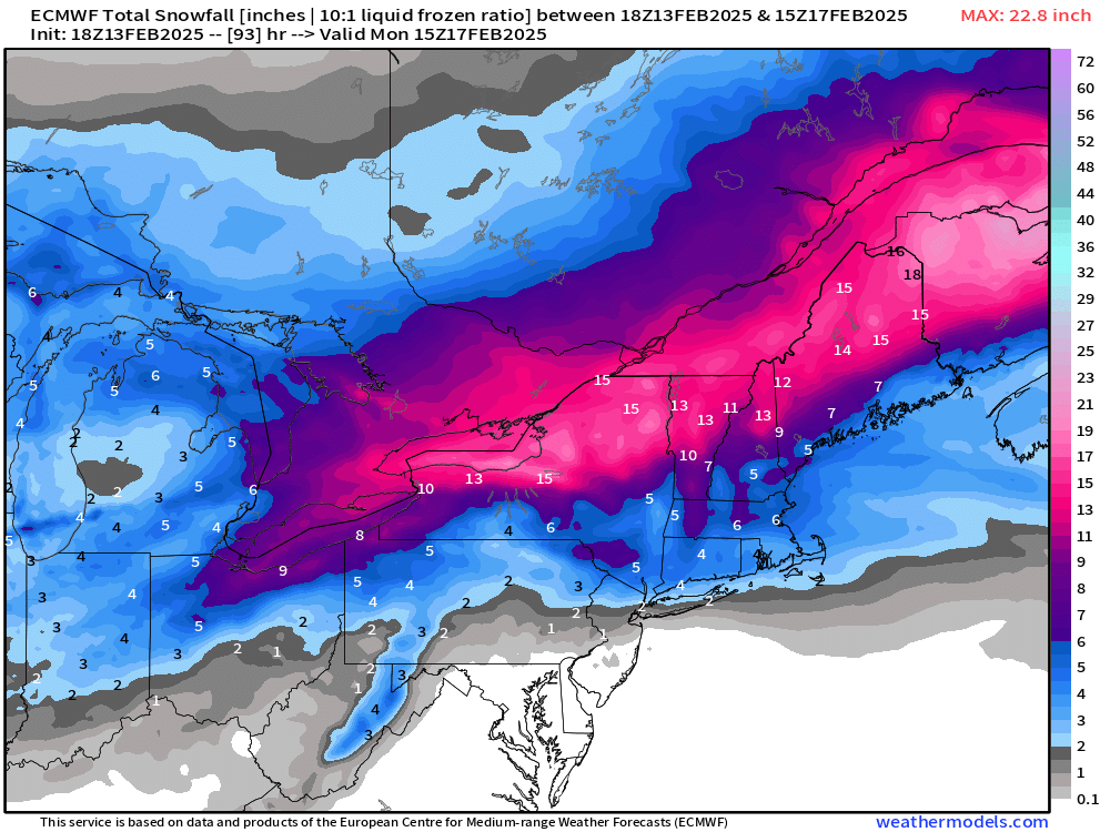
18z euro healthy front end. 4” S CT to 6” in pike/Rt 2 region.
-
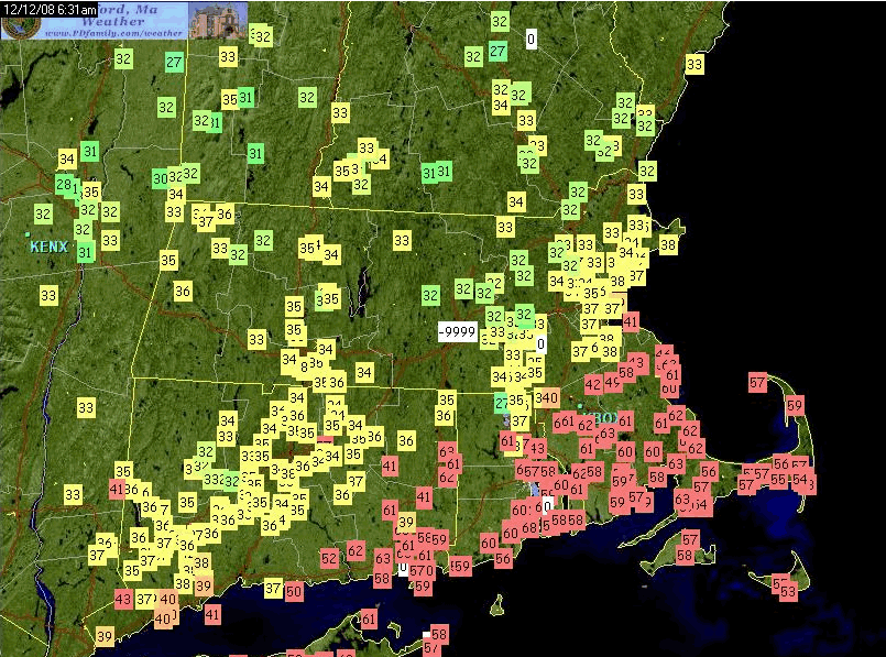
Except 2008, lol. I think I was at about 30-31F for 90% of that event. But we had very good dewpoint advection in that one. Like 15-20 knot northeast sustained. It was also a QPF bomb with like 3” of liquid.
-
-
There’s def potential for good ice but I’d like to see QPF after the snow thump be a little stronger OR the CAD hold really tough at the sfc due to earlier mesolow. The euro had like 0.75-1.00 of QPF over about 18 hours there after you flip from snow to sleet…and if a lot of that can fall as ZR and accrete efficiently (either light fall rates or sfc temps in the upper 20s), then it gets a lot more interesting for something in the 3/8ths range.
-
Yeah it tried for 50s here I think at one point, lol. Most runs were more tame. But it can get a little happy with the erosion of CAD sometimes.
-
I'm not sure there is enough QPF that falls as straight ZR to make this a larger impact icing event. There will def be some icing, but it seems like mostly less than 3 tenths to me. I guess if we develop the secondary a little sooner, then maybe there's a narrow zone for more ala the Icon model. Developing the secondary sooner will also help sleet go further south too for longer before the flip....so it's hard to get high end icing.
-
GFS is still wedging very strongly. It's def a bit more zonked with primary but that confluence to the northeast is strong, so once again places like ORH never crack freezing. Front end snow was a little better than 12z too....the 12z run was pretty flaccid....moreso than the other guidance.
-
GFS looking pretty zonked through 54h. Decided not to follow the 12z Euro trend.
-
For the real cold stuff to drain down, you'd want a much stronger mesolow earlier....I don't that that's going to happen, but even as is, the NAM doesn't get you above 35F until briefly spiking 40F during FROPA.
-
High here was 36.4F but it's been rotting around 35-35.5 the last 2 hours....we def got a little drop after that mesolow went by....didn't do much, but it prevented further rises. Amazingly, this might end up a net-gainer from 1.5" of dense junk....at the very least, we won't lose any of the prior pack.
-
The smells like a classic Brett/@TauntonBlizzard2013storm where he cancels it 3 different times over the next week and then he puts up a 20-burger in a deformation band that annihilates SE MA.
-
Pretty good front enders on the JV models too....generally 4-6" for the pike region which is matching the Euro and EPS. It actually snows for quite some time....just not all that heavily. About 10-12 hours of WAA snows.
-
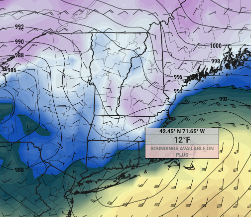
Lol at the CF on the ICON.....I put the mouse over about Tip's location near 495 there....12F while its above freezing just E of 128
-
Def helping the snowfall mean this far out...mean at BOS is about 6" for that storm.
-
EPS mean matches OP pretty well for snowfall on this one. 5-6" for Pike region up to near Rt 2....6-7" for north of Rt 2....about 4" for most of CT/N RI. 3" for south coast.
-
Got up to 36F but it's actually dropped to 35F last hour. "Cold tuck" as secondary passes by....it's just not very different from the current temps....we aren't going from 36 to 28 on this.
-
No, that's for Sunday
-
Check in on Sunday morning to see if this is still interesting.
-
That’s a pretty solid net-gainer on euro. 5-6” in pike region and then struggles to ever crack freezing (prob stays below freezing N of pike and outside of 495 that run) Would be nice to get one more tick colder though.
-
CLose call though
-
Canadain looks maybe a touch warmer than 00z, but still pretty similar in that it keeps the primary to PA before it redevelops eastward....keeps the pike region sleet kind of like 00z. Def on the colder side of guidance


