ORH_wxman
-
Posts
90,892 -
Joined
-
Last visited
Content Type
Profiles
Blogs
Forums
American Weather
Media Demo
Store
Gallery
Everything posted by ORH_wxman
-
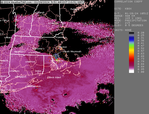
Was pelting for about 40 min but now big aggregates…still hearing a pinger or two bit transition almost complete.
-
Yeah I think we want to see some snow reports by 8-9am in N CT to be optimistic about at least advisory snows. I was looping the meso guidance and pound time really needs to happen there between 9am-1pm…so if you’re still struggling to snow once into that time range, it’s prob not happening for accumulations.
-
Not even sure it’s another MLK. I don’t think it looks that good up in MA either…I’d be surprised if anyone got more than 4-5” except maybe northern half of ORH county/southern monads and over to Berkshires.
-
We’ll see if Kevin can flip in the next 1-2 hours. If not, that basically means nada for most of CT east of Litchfield county at least. Dual pol does look like snow north of Ginxy in N RI and extreme NE CT but hard to say if any of that is reaching the ground as snow or just melts prior to reaching sfc.
-
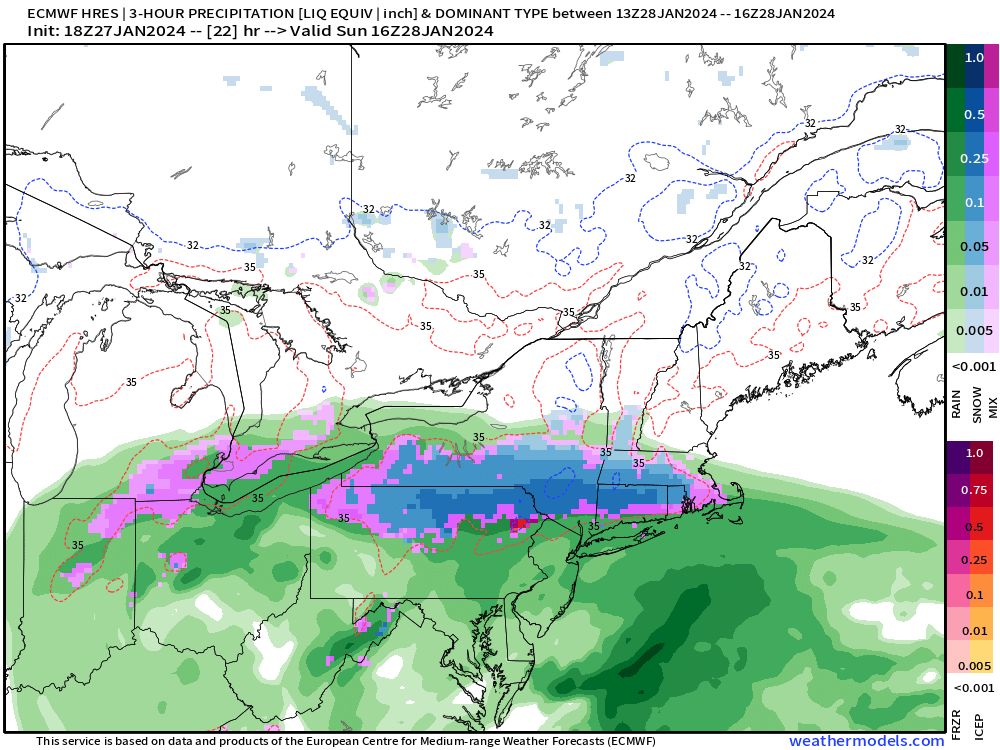
NAM keeps it going into Monday afternoon for a chunk of the area.
-
In this type of storm it really is. ORH county above 600-700 feet will be pretty easy. They will snow and amounts will be mostly determined by QPF. Lower down though is a disaster to try and forecast and it’s even worse down in CT where you have to consider midlevel temps being what they are.
-
I’m not that optimistic on the front end thump. Feel like best shot at accums is the CCB stuff even if it’s not heavy…it will at least have a colder column. Easier to accumulate at 32-33 when 925 is like -2 or -3 than isothermal. But it’s admittedly a real tough call because heavy rates will trump a lot of issues. The problem is you can’t guarantee heavy rates. Can we get 0.2” per hour QPF? Maybe. But there’s a huge difference between that and like 0.08-0.12 per hour.
-
It’s almost totally isothermal at 0C so the ptype maps are snow even if 850 temps are technically above 0C. But it’s prob like 0.2C or something. It’s close.
-
I’d def feel more optimistic in CT than earlier. At least the northern half of the state with a little elevation. Hills could score well on the thump.
-
Actually gets a hint of a CCB going.
-
It was a Flop... February 2024 Disco. Thread
ORH_wxman replied to Prismshine Productions's topic in New England
You’re not gonna snow with a ULL going from Detroit to Pittsburgh then looping east and the back NW toward BUF. That’s an ugly upper air look. But that’s exotically far west compared to everything including the ensembles that just came out. -
Meh. Not impressed. Euro hasn’t had a good CCB in several runs now. Synoptically with the way the lows track, you’d think someone would do well between CNE and the pike for a while before the whole thing collapses SE but it’s just showing light precip in that zone. The conveyor circulations just never get linked up on this storm very well and I think it’s causing a lot of headaches on these solutions. I don’t know how real it is, but it’s a red flag for sure.
-
I think you’d need to be north of the Merritt to have a shot. North of HFD even better. But it’s definitely going to be all about the rates/lift.
-
Euro is thumpy in CT but man, that’s so close on the thermals. Could legit see 4” of wet cement or rain/white rain from that.
-
Western areas of ORH county def get the Springfield channels but yeah, most of them are going to be tuning into Boston networks. Could be tough sledding in the valley in this type of system. Though you might have enough latitude to do a lot better than the valley further south of you.
-
Def underdone in N ORH county
-
Yes. I wasn’t saying WAA always is overdone, just more often than CCB stuff. Front end thumps can be awesome…but models will sometimes overdo it. 12/16/07 is often our favorite WAA event to talk about around here.
-
There’s usually good snow growth in the CCB stuff too because you are saturated well into the column whereas the WAA stuff can dryslot pretty quickly above 600-700mb. So I could see a lot of premature bust calls and then by Monday evening some areas will be thinking “oh I got another 3” today so it salvaged the storm to respectable”
-
I do think some of the CCB stuff could be undermodeled…esp Monday morning. Typically, models biases (and I believe this is still generally true even now in my experience) tend to overdo the WAA stuff and underdo the CCB stuff. But we’ll see. This is a weird system with all sorts of issues and there’s prob going to be a lot of nowcasting.
-
It was a Flop... February 2024 Disco. Thread
ORH_wxman replied to Prismshine Productions's topic in New England
Omega trying to spike footballs if we get a pattern he explicitly said wasn’t going to happen would be the meme….
-
There’s a lot of bust potential in this system. Both directions too…though the downside bust potential is greater imho. But there’s also some scenarios where I could see a foot-plus over interior if things work out well.
-
The CCB in general just doesn’t look that good anywhere right now on a consistent basis. There’s been runs where it does but many where it doesn’t. So I think I’m remaining conservative until that part is ironed out.
-
Yeah the thump is the way for CT to do well. I’d be skeptical until you see the whites of their eyes, but it’s been trending better. Need rates to go isothermal.
-
12km looked like it ticked south. Barely gets any decent QPF north of MHT…but 3k def went north a bit.