

ORH_wxman
-
Posts
93,099 -
Joined
-
Last visited
Content Type
Profiles
Blogs
Forums
American Weather
Media Demo
Store
Gallery
Everything posted by ORH_wxman
-
First Winter Storm to kickoff 2025-26 Winter season
ORH_wxman replied to Baroclinic Zone's topic in New England
Yeah mean either but also not sold on the low going up your Fanny or even Canal runners. Tough forecast. -
First Winter Storm to kickoff 2025-26 Winter season
ORH_wxman replied to Baroclinic Zone's topic in New England
NAM and ICON get play because they come out first. -
Good news is the EPS has been manhandling the GEFS for the early December period. GEFS has been caving to EPS when it gets to like D10-11-12. Hopefully that continues because EPS looks really good. Even popping western ridging week 2 where a more substantial system could develop in that look.
-
First Winter Storm to kickoff 2025-26 Winter season
ORH_wxman replied to Baroclinic Zone's topic in New England
All of these H5 looks (not including the NAM which goes crazy deep and consolidated) are trending toward this partial phase with northern stream and the vort gets sheared and attenuates…this is turning this system pretty ugly from an organization standpoint. I’d like to see a trend back toward keeping the southern vort a little more independent longer at 00z tonight but I’m becoming skeptical we will see that. -
First Winter Storm to kickoff 2025-26 Winter season
ORH_wxman replied to Baroclinic Zone's topic in New England
I’m tossing the NAM. Even the crazy GFS runs weren’t that amped. -
First Winter Storm to kickoff 2025-26 Winter season
ORH_wxman replied to Baroclinic Zone's topic in New England
They are gonna be really bad near the isothermal mix line. But I think they will be fine over the interior and comfortably north of the 0C 925-850 zone. -
First Winter Storm to kickoff 2025-26 Winter season
ORH_wxman replied to Baroclinic Zone's topic in New England
Yeah it has 6”+ here. I’m still pretty pessimistic for warning snows but maybe advisory has a decent chance. -
First Winter Storm to kickoff 2025-26 Winter season
ORH_wxman replied to Baroclinic Zone's topic in New England
Yes. But prob just advisory snows. -
First Winter Storm to kickoff 2025-26 Winter season
ORH_wxman replied to Baroclinic Zone's topic in New England
It’s prob gonna be a compromise lime usual. But evena compromise isn’t that great because the trend has been to keep the midlevels kind of open. So it’s gonna be weaker with dynamics and QPF. -
First Winter Storm to kickoff 2025-26 Winter season
ORH_wxman replied to Baroclinic Zone's topic in New England
Yep still shunts east like 06z. Kind of ugly. Would be cold enough across a lot of SNE but flaccid rates mean 2-4” type deal or even less near coast. -
First Winter Storm to kickoff 2025-26 Winter season
ORH_wxman replied to Baroclinic Zone's topic in New England
It’s still not as phased as those other solutions but keep an eye on trends. -
First Winter Storm to kickoff 2025-26 Winter season
ORH_wxman replied to Baroclinic Zone's topic in New England
12z euro looks more phased so I’m thinking we’re gonna get the big WAA push ahead of it instead of turning things to the east quicker. If that trend continues, it probably turns into a mostly non-event for SNE. -
First Winter Storm to kickoff 2025-26 Winter season
ORH_wxman replied to Baroclinic Zone's topic in New England
Yeah the Ukie is quite flaccid with rates. Not gonna be much warning snow on that look. -
First Winter Storm to kickoff 2025-26 Winter season
ORH_wxman replied to Baroclinic Zone's topic in New England
Euro is keeping that southern vort independent of the northern stream for quite a bit longer. These more amped models are trying to phase earlier so you get a big WAA surge out ahead of it. -
First Winter Storm to kickoff 2025-26 Winter season
ORH_wxman replied to Baroclinic Zone's topic in New England
GGEM was even slower than the GFS to turn the low and midlevels out of the east. And it’s because of how it handles the vort. It keeps a strong vort tracking through western NY. You aren’t getting big snowstorms for a good chunk of New England like that. -
First Winter Storm to kickoff 2025-26 Winter season
ORH_wxman replied to Baroclinic Zone's topic in New England
Similar but def warmer. -
First Winter Storm to kickoff 2025-26 Winter season
ORH_wxman replied to Baroclinic Zone's topic in New England
That was a trend better for SNE than previous runs. Still warmish but it at least holds snow for longer…gives you maybe advisory snows instead of a quick coating. -
First Winter Storm to kickoff 2025-26 Winter season
ORH_wxman replied to Baroclinic Zone's topic in New England
It’s not developing the 850-925 lows as quickly as those colder looks. It just keeps everything ripping out of the south. At 78h, it has a closed 925 low off Delmarva but it’s due south winds here. Zero turning of the winds early on. Euro has a closed low off Delmarva at 925 with winds almost out of due east. -
First Winter Storm to kickoff 2025-26 Winter season
ORH_wxman replied to Baroclinic Zone's topic in New England
This run will be a bit less zonked than 06z it looks like. -
First Winter Storm to kickoff 2025-26 Winter season
ORH_wxman replied to Baroclinic Zone's topic in New England
That’s what it did in BOS. It had like -1C to -2C at 925 there. I agree this is a massively heavy lift for BOS but that’s how it would have to go. 00z euro rates and temp profile -
First Winter Storm to kickoff 2025-26 Winter season
ORH_wxman replied to Baroclinic Zone's topic in New England
Watch the 00z euro verify now. -
First Winter Storm to kickoff 2025-26 Winter season
ORH_wxman replied to Baroclinic Zone's topic in New England
We had this a few times last year…models becoming more divergent inside of 4 days. Seeing the euro go so flat at 06z to almost whiffing and then seeing monster amped solutions at the same time from other guidance…. -
First Winter Storm to kickoff 2025-26 Winter season
ORH_wxman replied to Baroclinic Zone's topic in New England
Meanwhile the ARW is so flat there’s basically no storm. -
First Winter Storm to kickoff 2025-26 Winter season
ORH_wxman replied to Baroclinic Zone's topic in New England
Here’s the meat of the storm with the real rates on the 00z euro….paste zone is prob more like SE MA to interior SE CT on that look…interior MA to interior N CT is prob a degree or two cold enough to not be too pasty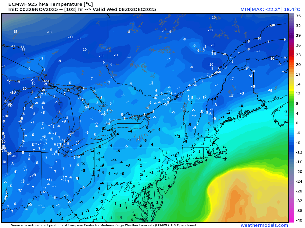
-
First Winter Storm to kickoff 2025-26 Winter season
ORH_wxman replied to Baroclinic Zone's topic in New England
The thing is, if you amped the euro solution from 00z just a bit more, then you and me would prob see a lot more paste, Kevin since we’d be closer to 0C from like 900mb to surface. But if it’s more like -2C then it’s gonna be more powdery.


