ORH_wxman
-
Posts
90,892 -
Joined
-
Last visited
Content Type
Profiles
Blogs
Forums
American Weather
Media Demo
Store
Gallery
Everything posted by ORH_wxman
-
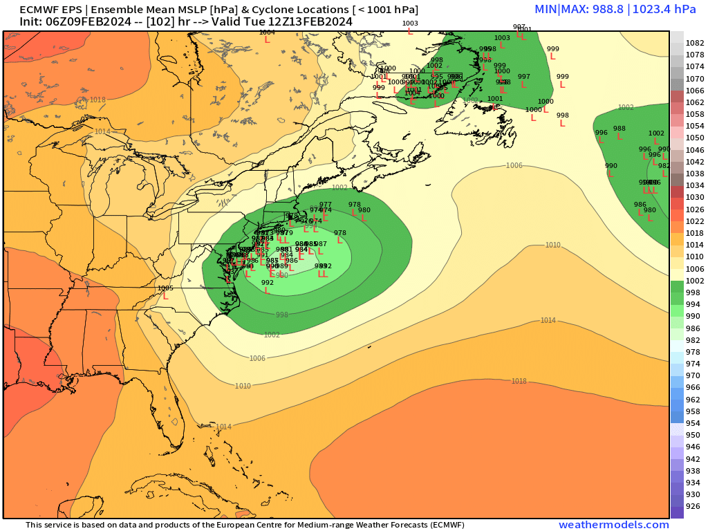
It’s a good sign that we’re getting oscillations now in the past few cycles…not a discernible trend. It def could still trend but usually when you start oscillating it means the trends are probably not going to be steep.
-
Now out to the end of the run at 90h…it’s def south of 12z
-
18z euro looks a tad south of 12z through 78h. Not totally shocking given the 12z eps.
-
Yeah I’m about ready to toss anything well south. I could still see N of pike getting only a moderate event from a system further south but it’s becoming less likely. I still think the zone with the most wiggle room is prob your area down to N CT around Kevin. I think central and south-central CT is in decent shape too but a N tick could make it a sloppier event with maybe a longer wait for the snow there.
-
Outliers are converging
-
That’s a fat PV to the north. It’s not going to rip inland with that setup. There’s def a northern limit. The goal posts are prob like dendrite to south coast right now for the meat of the snow.
-
I think eventually (esp interior) but the first 2-4 hours might be pasty.
-
Thought eps would be more zonked. I’d feel really good from Ray to N CT right now. But both MHT region and S CT are still in line for at least plowable…we’ll see.
-
Ukie still a meat grinder job. But it was def less of a meat grinder than 00z run. 00z was a clean whiff and 12z is a scraper.
-
Yes it was the same system. It just had a couple vort pulses but it was all part of the same ULL
-
That’s a big jump on the last frame…esp looking at the isobars in the gulf of maine
-
In your hood? Prob Dec 2019…I can’t remember if you got a bit skunked in the Feb 1-2, 2021 storm…and I know you were way too far west for Jan 2022
-
It was a Flop... February 2024 Disco. Thread
ORH_wxman replied to Prismshine Productions's topic in New England
16th has clipper/little critter potential that @Typhoon Tip and I have been referring to the last day or so. Pretty vigorous northern stream s/w…if we can track that in the vicinity of LI then look out for a solid stripe of snow over SNE/CNE. -
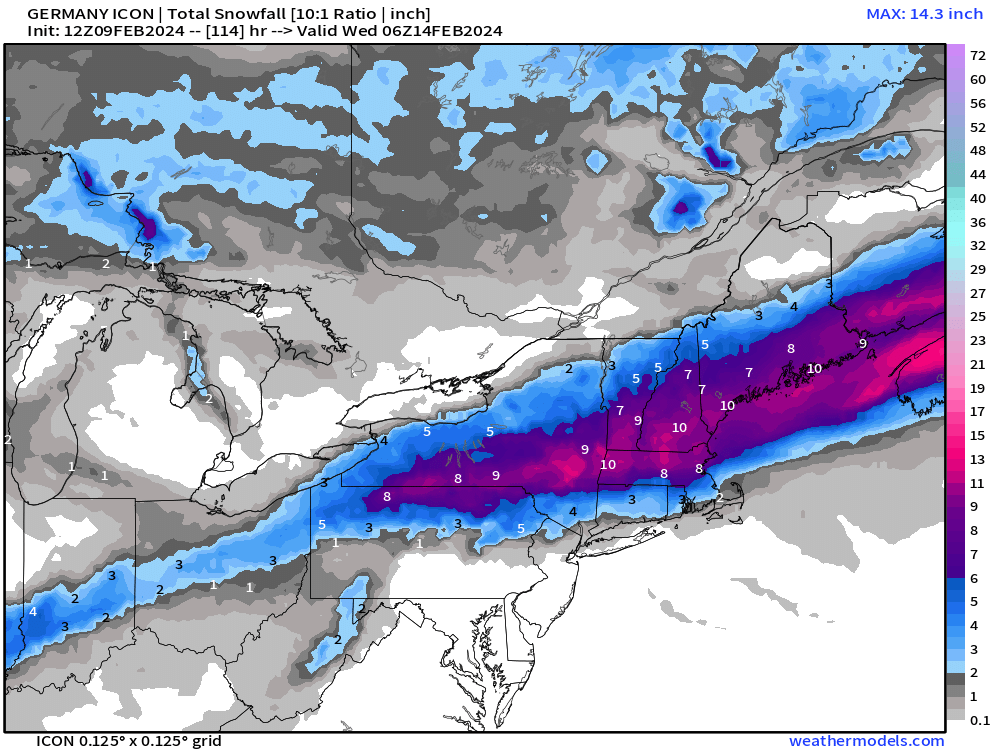
2013 might be #2 all time in CT behind 1888. What a ridiculous coverage of 25”+.
-
I think there’s still a lot more uncertainty in this system than many of us (including myself) are giving it credit for. That’s a huge gap between models inside of 100 hours. My gut still says this will not be south but you can’t completely ignore the southern solutions. I’d say you can probably toss the total whiffs but you may need to entertain the possibility we get something a bit more sheared ala the 12z NAM.
-
GGEM still a sheared mess. Whiff.
-
Definitely gotta keep that in the back of our minds. I don’t think it has room to fully phase but a little more partial phase wouldn’t be out of the question.
-
It was a Flop... February 2024 Disco. Thread
ORH_wxman replied to Prismshine Productions's topic in New England
To be more specific, there are two famous Presidents’ Day storms…that’s why people see “PDI and PDII”….the first one was 1979 and crushed DC to NYC but whiffed New England. The second one was 2003 and gave 20”+ from DC to Boston and most SNE. Even CNE got decent snows but not quite as much. -
Pretty zonked actually.
-
RGEM looks a lot healthier with the shortwave than the NAM
-
Yep that reminds me of the Ukie and GGEM last night. It’s further north than those two models but the idea of shearing the southern stream vort is similar. That’s definitely what we DONT want to see because then you end up with crappy rates and lower ceiling for the event.
-
It was a Flop... February 2024 Disco. Thread
ORH_wxman replied to Prismshine Productions's topic in New England
I’m addition to the strong 2/24 signal, we’re starting to see a cluster of lows show up near the BM and further southwest (timing variance) on the individual ensemble plot for 2/19ish. Pretty good to start seeing some clusters at D10 -
06z euro at 90h looks a little more amped than 00z at 96h fwiw. Maybe seeing some stabilizing of the S trend…we’ll know a lot more at 12z. We’ll be getting into that sub-100 hour range now on the 12z guidance which is when confidence starts ramping up faster.
-
Nice to see 06z runs look a little better.