ORH_wxman
-
Posts
90,892 -
Joined
-
Last visited
Content Type
Profiles
Blogs
Forums
American Weather
Media Demo
Store
Gallery
Everything posted by ORH_wxman
-
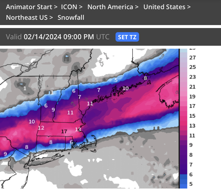
Yeah I think my over/under there is about 7” at Logan but back bay may be more like 9-10”
-
Yeah I mean I’m not worried here about much here except whether it’s 8” or 15”…first world problems for snow lovers. But I think most of SNE is safe for warning criteria if you’re more than 5-10 miles away from the water…I’m pretty confident BOS will get warning criteria but it could still go sideways there with advisory slop if a bunch of things go wrong such as rates, storm moves too quickly after sfc cools to freezing, etc.
-
I think they’ll keep inching north but I’m guessing the northern ones come south too. We’ve already sort of seen that the last couple runs….euro will be interesting of course.
-
Yeah I thought I was gonna get like an 18-burger that run when I saw what aloft looked like at 51 hours but then it didn’t really show up on QPF. Speed of this system is what is keeping me from going fully crazy bullish IMBY. I feel good about 8-12 but still potential for higher if we can pseudo-stall it for like 2 hours during the capture. GFS didn’t really allow that.
-
Escapes east a bit before it can really destroy us….
-
It was a Flop... February 2024 Disco. Thread
ORH_wxman replied to Prismshine Productions's topic in New England
I mean, the OP euro last night at D9-10 was pretty obvious…but if we hate OP runs, the general pattern for something is there on the ensembles….you have a trough entering the Midwest/Oh valley with a 50/50 in place and even a bit of a WAR to try and push this back west if it tries to escape east. I’m not honking or anything yet but there’s certainly potential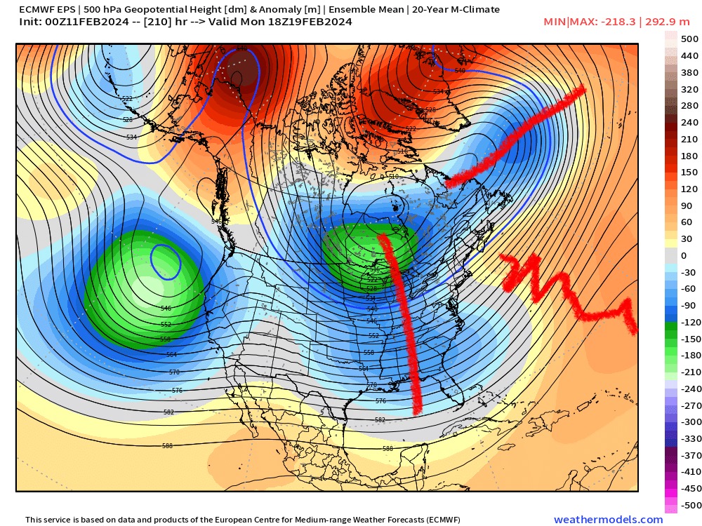
-
Icon ticked south again so I think we’re starting to converge. Not that we really care about that model but I try to look for trends in the outliers.
-
Still very confidently going with that ICON run that had no warning snow south of route 2?
-
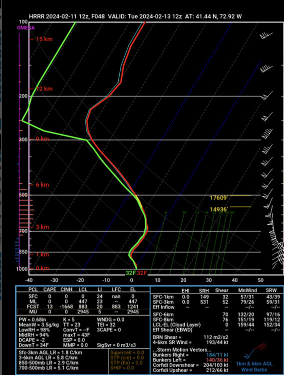
Hrrr is pound town for CT Tuesday morning.
-
Different issue…h7 track is mostly independent of antecedent airmass. I say “mostly” because a really cold antecedent airmass would probably force things a little south even aloft. The problem so often the last two years has been basically no good high to the north. And the couple times we’ve had a decent high, it wasn’t a fresh airmass.
-
It was a Flop... February 2024 Disco. Thread
ORH_wxman replied to Prismshine Productions's topic in New England
There’s some threats after the clipper too. 2/20-21 is starting to show up more. Some guidance tries to sneak in a smaller threat 2/17-18 too. -
I usually don’t expect messenger ticks until very late. We’ll see what 12z does. 06z easily could’ve just been a slight wobble and not a trend.
-
Yeah they’ll def still tick north, but I wonder if globals stabilize or even come a tick south again (like 06z did)…I usually expect everything to bump a little north in the 48-60 time range.
-
Weird how the mesos are lagging so much in globals.
-
06z euro looks a tick less zonked too.
-
06z GFS might have been the first run in a while on that model that ticked a little south. Small amount though as has been with that model throughout this threat. It’s been acting like the old euro with small moves.
-
Not sure. GFS has showed it a few times but it hasn’t been showing up much on other guidance I checked. The partial phase does show the thing going really neg tilt at that point on the GFS and maybe it gets one last shot of moisture from the convective WCB wrapping all the way into the CCB….but yeah, kind of weird how and can only speculate
-
Why wouldn’t it be ok to post? As long as it’s a freebie, people can post.
-
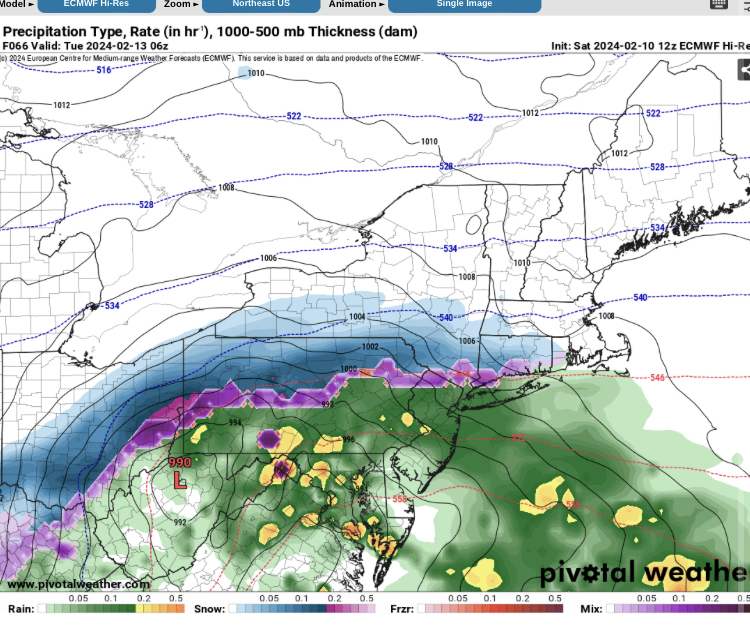
00z NAM looks like confluence is stronger in front of the wave than 18z. But northern stream is trying to dive in behind it for the partial phase.
-
ARW should do it sometime between now and 15z run tomorrow
-
Much less impressive aloft that run but that’s gonna happen. It’s why we’re not forecasting 1-2 feet. But I think the general idea of a favorable track puts a floor of about 7-8” there. Exact dynamic evolution still TBD which will determine whether it’s 8-10” or 12-18” in your area.
-
Yeah agreed and I’m not even really counting a few drops at the onset for a place like HFD down to MMK before they wetbulb…when the real precip gets going, it’s going to be snow unless we see some drastic change in guidance over the next 24-36h.
-
Don’t think so
-
On what model? The ICON?