

ORH_wxman
-
Posts
90,902 -
Joined
-
Last visited
Content Type
Profiles
Blogs
Forums
American Weather
Media Demo
Store
Gallery
Everything posted by ORH_wxman
-
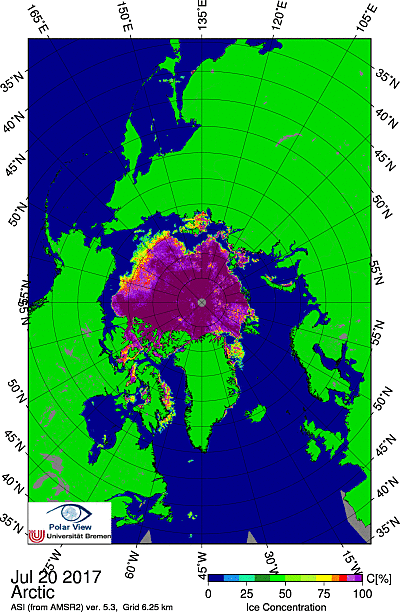
Update for 2017.... Extent is still tracking pretty low...basically in a dead heat right now with 2016 for 4th lowest, though I would be surprised if it kept up pace since 2016 had breathtaking losses late in the month with a ton of vulnerable nearly-melted-out ice in the ESS and managed to finish 2nd lowest...2017 has no such vast areas so vulnerable, so we'd expect a slowdown relative to 2016. That said, there is still room for a pretty low result, top 5 lowest is still definitely within reach and you still cannot quite rule out 2nd lowest if the weather was absolutely hostile to the max. But the race may be more with 2011/2015. Area is a bit of a different story...the ice is pretty compact...not nearly as spread out as some other years. So area is running higher than extent in the rankings. Here are the August 17th (based on 8/16 satellite scan) area numbers by year: 2017: 3.69 million sq km 2016: 3.26 2015: 3.51 2014: 4.53 2013: 4.10 2012: 2.92 2011: 3.32 2010: 3.92 2009: 3.95 2008: 3.67 2007: 3.23 2008 is currently the closest match, then 2015 is next closest. 2008 finished at 3.00 million sq km while 2015 finished at 3.09 million sq km. The ice pack is currently more compact than both of those years so it wouldn't be shocking if it finished higher...however, it is also probably thinner out on the PAC side, so that could offset the compactness some and still produce area losses that are more comparable to a dispersed ice pack....weather of course will be a factor too, so we'll just have to see. A finish anywhere from 3rd lowest to 7th lowest is still plausible on area...I think 2012 and 2016 are now safely out of reach as well as 2009, 2013, and 2014.
-
Yeah it's actually a pretty compact ice pack right now. I think the cyclone perhaps has just slowed the peripheral melting. Though bluewave is correct that typically cyclones over the CAB try and disperse the ice. But the concentration hasn't suffered even if it is doing that.
-
Cryosphere Today...it was a webpage from U Illinois that tracked sea ice area from the SSMI/S satellite. NSIDC uses the same one but they don't really show much data on area...all their graphs are extent. CT put the area in graphical format and also in tabular format. But it stopped transmitting data sometime in early 2016...at first they said they were going to be back soon but then the site went dark and it never updated. Area is nice to use because it tends to be a better predictor of extent 30-60 days out than extent itself is...but not having CT's easy-to-read data is really annoying.
-
NSIDC (CT SIA's source) is still transmitting SSMI/S and wipneus posts it...but it is really annoying that we don't have it on the CT SIA graph and also their spreadsheet which made it easy to look up. But area right now sits at 4.03 million sq km. That would be 7th place...barely under 2010 . Other years: 2016: 3.70 2015: 3.79 2014: 4.55 2013: 4.31 2012: 3.09 2011: 3.56 2010: 4.06 2009: 4.33 2008: 3.89 2007: 3.68
-
We have a pretty compact ice pack right now...area is running about 6th lowest but extent is flirting around the 3rd lowest mark right now only above 2007 and 2012 though on a few of the data sources it is a bit above 2016 as well. My guess is that we may see extent loss slow some at some point and area loss pick up a little more or at least pick up relative to extent loss. Most of the years with similar compactness right now saw some noticeable slowing of extent loss. We have a pretty strong storm right now in the Arctic and it is late enough in the season that perhaps it could do some damage. Kind of like the 2012 cyclone but less extreme since it is both weaker and the ice this year is not as in bad shape as 2012 was before that cyclone hit. We will see if it damages the ice enough to cause a late season cliff in extent loss. I'm probably leaning against anything huge though given the higher area right now...but you never know. If we form a potent dipole late in August that helps compact the ice more we could see big extent loss anyway like we saw in 2015 (that year ended on a huge extent cliff even while area loss was light)
-
The cold pool in the North Atlantic also really expanded and intensified in 2013 which was right after the huge Greenland melt in 2012...so I wonder if that was at least partially related.
-
There is a cyclical pattern on top of the underlying anthropogenic warming. The Arctic is kind of a tough one though because it has previously responded to global temperature changes much more rapidly than other regions...so we don't have a great idea on how it will behave with added anthropogenic warming. We do know that it warmed about 5x the rate of the rest of the globe in the early 20th century and cooled about 5x the rate during the cooling period 1940-1970...and recently it has warmed about 10x faster than the rest of the globe. There's probably been some natural warming helping out since the mid 90s when the AMO flipped on top of anthro warming. As for the ice, there was a paper that came out (Tietche et al) in 2011 that had looked at what happens when we approach an ice-free state and if it caused any "tipping point". It found that it did not...it actually found the opposite conclusion...which suggested as we get closer to ice free, it may take longer to get that final push than it did to go from 1990s levels to 2007 levels of ice. It showed that winter temps need to be about 2-3C warmer than currently (or maybe another 1-1.5c if you just use last winter's excessively warm temps) to consistently have a great chance to melt all the ice out in summer using model projected 2050 temps. Now, maybe this is too optimistic for the ice...it has shrunk faster than previous models said it would so we will have to see if that trend continues...or if the flattening happens. There's some recent argument for both cases...on the one hand, we have basically a flat trend in area/extent since 2007 and we've seen rebounds following record lows which follows the Tietche et al theory, but the volume trend is still downward too so will there some "flash melting" type event? Maybe...if we keep the volume trend down, then yeah it could happen pretty soon. But we've seen volume rebounds after records so of the same happens after this season, then it will probably push the ice-free date back another couple years.
-
Yeah the vortex is mostly hanging out over the CAB...there's a pretty strong storm in the couple days...we'll see if that is strong enough to do any damage. But it is definitely not the typical pattern for huge melting out shown through mid-month. The biggest enemy of the ice is how thin it was at the beginning of the year. If this pattern happened in 2015, we probably would have seen a minimum extent in the mid 5s.
-
PIOMAS updated for August 1st....2017 has now relinquished its place for lowest volume to 2012 for the first time this year...albeit still very close. I think it is unlikely 2017 will be able to match 2012's losses from here on out, but if the weather is bad enough, who knows for sure.
-
The effect is too small to really make a difference. Maybe only 0.3 watts per meter sq in high amplitude cases....which might be like a tenth of a degree Celsius, but most likely the impact is less. If we had an extended min for like a decade or longer, then it might be somewhat noticeable.
-
You're correct...you can use the other years as baselines....higher ice years like 2009 and 2014 are larger positive values.
-
Late month update on area....how other years compare to 2017: 2016: -300k 2015: -190k 2014: +340k 2013: +50k 2012: -520k 2011: -330k 2010: -110k 2009: +410k 2008: +350k 2007: -320k We are closest to 2013 right now, but when you look at the numbers, it doesn't necessarily that means where we will end up. You can see that 2008 still had pretty high area at this point (350k ahead of 2017 and 300k ahead of 2013), but much of it was vulnerable ice in the Laptev so it melted back quite a bit in August....whereas a year like 2013 had already melted out most of the vulnerable ice so it stalled and finished significantly higher than a year like 2008. The next closest year is 2010. I still think a finish close to 2010 is probably the most likely right now. That year finished at 3.07 million sq km for area....though really anything plus or minus 200k from that is fair game.
-
There's some good stuff in there if you just wade through all the hyperbole. Wipneus does a fantastic job on NSIDC area and extent data and piomas volume data...that's the main reason I visit the site at all.
-
It is definitely weird that we saw an abrupt flip. I wish we knew what caused it. It seems to coincide with the formation of the deep cold pool anomaly in the North Atlantic sometime in spring of 2013 when the deep blocking from early that spring broke down. But I'm not sure what is cause and what is effect and also what is just reinforcing feedback. Probably some combo but interesting nonetheless. The hadgem model from Hadley center seemed to predict this on some level after 2012...which is a nice score by that model.
-
Yeah if you read the Arctic sea ice forums, most of them are convinced every season is going to be a record low. There's a select few posters on there that do a good job and are pretty objective about the data but you can ignore the other 90% of them. As skier said, most of them just post anecdotes...pictures of buoy webcams or zoomed-in visible satellite pics that show ice "rubble" and then claim that means it has to melt out this year. There's no doubt that this year started off really bad coming out of winter...likely worst on record...but it's clear now that we didn't carry that momentum into spring and summer. It will still be a pretty low ice year because of how bad we started, but I don't think we will get near any records. Maybe volume can still be close if we get some hostile weather in August.
-
Extent has been keeping pace with the bottom years for the time being even though area has not. Seems like we've gotten a pretty compact ice pack now which has aided in the extent decline. We also lost a good amount of ice in the Greenland sea over the past few weeks as export has come to halt. I'd expect at some point we're going to see a decent stall (or slowdown to be more accurate) in extent loss once the easy pickings are gone...still some fast ice that broke off lingering int hje Laptev and Baffin Sea has some stubborn ice too that will probably contribute to losses in the next few days. The late Andrew Slater's page has the extent minimum coming in around 4.6 million sq km (assuming the value on 9/9 is close to the min), so I think we'll get below 5 million sq km for the daily min. His method has been remarkably accurate for a 50 day forecast...rarely missing by more than a couple hundred thousand sq km. His method also does have a pretty big flattening out in the extent loss in late July and early August...so that supports the idea above, but path to the min isn't always as accurate. The 2012 August losses are pretty easy to see the reason...it was such low concentration already by this point...the difference compared to 2017 is pretty stark:
-
PIOMAS had a mid-month update....2017 is still lower than 2012 by a very slim margin. It is 150 km^3 lower than 2012...it was 180 km^3 lower on July 1st update so basically no change. However, the difference in the CAB has shrunk to almost zero...compared to July 1st which had quite a bit more CAB volume in 2012 versus 2017. So I think it is only a matter of time before 2012 runs away from this year...but we will see. Until the total number diverges, it is still a race. This seems to be supported by the area numbers too (NSIDC area as measured by SSMI/S)...after starting off the month with some big drops as noted earlier in this thread....we've come to a screeching halt in area loss. We are sitting at 5.62 million sq km for area right now which is more than 800,000 sq km above 2012 at this point (with the big August cyclone still looming in 2012). We are actually ahead of 2013 and 2014 right now as well, but I do not believe we will stay there because both of those years went into big pauses later this month.
-
Just get us a Kp index of 9 like October 2003. Only time I ever saw legit curtains with the naked eye.
-
Yeah I'm not sure what he is seeing that indicates we will go lower than 2012...there's still an outside chance we go lower on volume only because the very thick ice near Greenland and the CAA is quite a bit thinner than 2012...but the rest of the pack is in superior shape than 2012 was at this point, so it is hard to see how the area and extent get anywhere near it. Volume will be a task...it will require probably very hostile weather from here on out. We entered July nearly tied with 2012 for volume and so far this July has been significantly colder than 2012. We had a decent chance to beat 2012 on extent/area coming into May, but the weather since then has all but eliminated that chance now...never say never, but I'd put the odds probably below 10%. Maybe if we get a 2007-esque pattern later this month and right through all of August, we will make up ground.
-
Greenland is actually having a historically cold summer. Kind of weird obviously in the recent warm context but it's a reminder that natural variability still plays a large role.
-
Finally melting all that snowpack on the CAB ice and getting melt ponding. The bigger question though becomes is this happening too late? 2013 saw similar losses in the same period (670k) before stalling later in the month. OTOH, years like 2008 (the closest match to 2017 for area on June 30th) decided to go nuclear a few days later (about July 5-9 losing almost 800k) and finished pretty low...albeit still around 3.00 million sq km.
-
Also, probably one of the more underrated events during the whole decline of sea ice in the past decade-plus is the winter of 2007-2008. 2007 might not have been a complete game-changer had the 2007-2008 winter not exported a ton of that compacted multiyear ice. While the summer of '07 melted out a lot of volume, even more was exported the following winter...the '07 summer pushed/compacted all the MYI leftover from the 2006 season (and previous seasons) toward Greenland/CAA and then a really hostile winter/spring pattern proceeded to export a lot of that ice...expediting the transition from a lot of MYI to mostly FYI.
-
2012 and 2011 were fairly different in volume by September though, 2012 was clearly lower...they were close in July. A much better example IMHO would be 2007...it had a much higher September volume than years like 2013 and barely lower than 2009...yet it had one of the lowest extents/areas at the minimum due to the extreme compaction (caused by the weather)....way lower than 2009/2013.
-
Here's the distributions of the final area minimum should 2017 follow the same path of each previous year's melt after June 30th. (I.E. you can see that if we followed 2015's melt after June 30th, our minimum would be at 3.00 million sq km) Using percentiles, the 10th percentile is 2.87 million sq km and the 90th is 3.87 million sq km with a median of 3.31 million sq km...however, that is using the entire distribution since 1979 and as I noted in a discussion with skierinvermont, the recent years may be starting to trend a little higher for ice loss after June 30th...this isn't conclusive yet, but I think it should be mentioned. If we only use 2007-2016, then our percentiles would change...you'd get a 10th percentile of 2.80, a 90th perecentile of 3.31 and a median of 3.12. Note how the 90th percentile for post-2007 is the same as the median for the entire distribution...this is because in the past 10 years, we haven't had any of those very slow post-June 30th melt years like we saw especially in the 1990s....but even 2005 and 2006 were quite slow in area loss after June 30th. Thus, given all the information...my prediction for 2017 min will be 3.10 plus or minus 200,000 sq km...so a range of 2.90 to 3.30. This covers a lot of rankings of course. We could theoretically finish anywhere from #3 to #8.
-
Final June area numbers are in and my prediction will probably be somewhere around 3.1 million sqkm for area. I'll have the full expected distribution of results in the next day or two when I have time to run them on excel. We finished the month 250k higher than last year...so that is probably going to put the chances at beating 2012 near zero considering even last year's epic melt out post-June didn't break it.
